


Storms heading in tonight and continue through the weekend
July 18th, 2025 by Ric Hanson
(Radio Iowa) – The National Weather Service forecast is looking like we are in for a stormy weekend. Meteorologist Brooke Hagenhoff says it’ll get started tonight. “So, we’re looking at chances for some strong storms and it’s going to come in multiple rounds, starting very late this evening, kind of in the overnight period,” she says. “And then another on Saturday afternoon, and it looks like and likely more rounds on Sunday as well.”
The storms could bring a mixture of things with them. “Some gusty winds, areas of really heavy rain, some hail, are certainly possible with any of these that develop,” Hagenhoff says. Hagenhoff says the storms will develop differently. “So this first round that’s coming in this evening is going to come out of the northwest and then move across the state through the overnight areas exiting towards the southeast on Saturday morning,” she says. “The second round that is coming on Saturday afternoon is going to kind of. develop right on top of us, so it won’t come from anywhere to just kind of start forming across us. And once those storms develop, then they’ll start pushing off to the east with that round.” 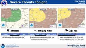
Hagenhoff says there could be some flash flooding in some of these storms. “It’s not going to be a widespread heavy rain for everyone, but areas that get those stronger thunderstorms could pick up several inches of rain pretty quickly in those instances,” Hagenhoff says. So, if you’re seeing some strong storms come near your area, be prepared for some isolated chances for some flash flooding with that as well.”
Hagenhoff says the cooler weather will hold through Monday, and then things will heat back up to the normal July temperatures.

