


Severe Thunderstorm Watch until Midnight for Cass & some area Counties
June 16th, 2025 by Ric Hanson
Severe Thunderstorm Watch Number 424
NWS Storm Prediction Center Norman OK
510 PM CDT Mon Jun 16 2025
The NWS Storm Prediction Center has issued a Severe Thunderstorm Watch until midnight for the following Counties in Iowa:
ADAIR ADAMS AUDUBON BUENA VISTA CALHOUN CARROLL CASS CHEROKEE CRAWFORD GREENE GUTHRIE HARRISON IDA MILLS MONONA MONTGOMERY PLYMOUTH POCAHONTAS POTTAWATTAMIE SAC SHELBY WOODBURY. 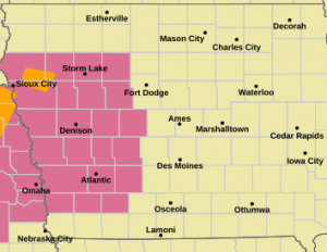
* Primary threats include…
Scattered damaging winds and isolated significant gusts to 80 mph likely
Scattered large hail and isolated very large hail events to 3 inches in diameter possible
A tornado or two possible
SUMMARY…Thunderstorm intensity and coverage is expected to increase across the region this afternoon/evening. Large to very large hail up to 3″ in diameter is possible with the initial more cellular development. Development into one or more convective lines is possible as well, with damaging gusts up to 75-80 mph as the primary risk once this linear transition occurs.
The severe thunderstorm watch area is approximately along and 60 statute miles north and south of a line from 40 miles north northwest of Imperial NE to 25 miles east southeast of Denison IA.
PRECAUTIONARY/PREPAREDNESS ACTIONS…
REMEMBER…A Severe Thunderstorm Watch means conditions are favorable for severe thunderstorms in and close to the watch area. Persons in these areas should be on the lookout for threatening weather conditions and listen for later statements and possible warnings. Severe thunderstorms can and occasionally do produce tornadoes.
