


Iowans need to stay weather aware as rough stuff is possible within hours
June 16th, 2025 by Ric Hanson
(Radio Iowa) – Forecasters say most of Iowa faces the risk of severe weather late this afternoon and tonight, with hail, high winds, heavy rain and tornadoes all possible, especially for western, northwestern and north-central Iowa. Meteorologist Brooke Hagenhoff, at the National Weather Service, says after a weekend where parts of Iowa saw more than two inches of rainfall, much more moisture is on the way through tomorrow.
“Isolated pockets across the state could see four inches or more, depending on how some of these storms set up, so we are monitoring the potential with these repeated heavy rain events kind of on back-to-back days,” Hagenhoff says. “There may be some potential for flash flooding as well as maybe some rises on area rivers as well.” 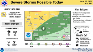
These are the final days of spring, with summer arriving this weekend, and Hagenhoff says the weather is shifting right on schedule. “We’re looking at a return to the 90s as we get towards next week and it’s going to remain muggy,” she says, “so it’s definitely going to feel much more summerlike as we get towards the end of the week.”
Summer officially arrives on Friday at 9:42 pm/Central.

