


Another day in the broiler for wide areas of Iowa, cooler tomorrow with rain
June 23rd, 2025 by Ric Hanson
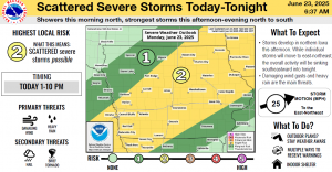
(Radio Iowa) – Forecasters say today (Monday) should be the last day of brutal heat with triple-digit heat indices for much of central, southern and eastern Iowa, as a front moves in tonight that should bring rain and somewhat cooler weather tomorrow. Meteorologist Dylan Dodson, at the National Weather Service, says nearly 40 Iowa counties are under a Heat Advisory through this evening as air temperatures will again be in the 90s, with heat indices as high as 105 degrees.
“Fortunately, we’ll be seeing some relief from those really hot temperatures here, as this front starts to move through,” Dodson says. “As we know, what comes with fronts is more rainfall, so we’re going to be looking at more rain here today and then into tonight and through most of the week, really.” Dodson says some areas of eastern Iowa will see high temps tomorrow drop by at least ten degrees compared to this afternoon. Showers tonight could be heavy in scattered areas, and the expected rain comes with some risks.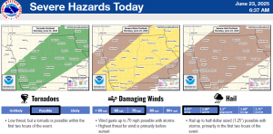
“As far as widespread flooding, we’re not expecting that, but we could see some flash flooding potentially over urban areas,” Dodson says. “As you know, if those storms can continue to track over one area for a long period of time, we could certainly see some ponding of water, potentially flash flooding.” Dodson says there were no record high temperatures set in Iowa over the weekend, but there were record lows set at night in the upper 70s and low 80s.

