


Forecasters say a blustery day is ahead for Iowa, mind your recycling bin
May 15th, 2025 by Ric Hanson
(Radio Iowa) – Strong thunderstorms rumbled across parts of northern Iowa this (Thursday) morning, and a wide area of the state is under a Wind Advisory today. The Advisory covers 34 counties in northwest, west-central and north-central Iowa from noon until 8 o’clock tonight. In the KJAN listening area, Harrison, Monona, Sac, Crawford and Carroll Counties are included in the Wind Advisory.
Meteorologist Rod Donavon, at the National Weather Service, says the powerful winds can make driving difficult, especially for high-profile vehicles, so use extra caution. “We will have increasing winds behind that boundary where we’ll see some wind gusts up towards 45 miles an hour,” Donavon says, “and that will likely last into the early evening hours.” Some gusts may be over 50 miles an hour, and he says anything in your yard that’s not secure could vanish, while tree limbs might snap, causing power outages.
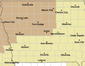
Wind Advisory for counties in light brown
Donavon says we may see a repeat tomorrow. “We will have another boundary, actually a colder front coming down during the day on Friday and that will be spreading strong winds across the state once again, mainly across the northern half,” he says. “That will have wind gusts up towards 45 miles per hour once again.”
After a warm week with unseasonable highs in parts of Iowa in the mid- to upper-80s, Donavon says it should be a cooler weekend, with highs in the 70s and the chance for rain Sunday night and Monday.

