


Storm damage reports from 4/17-18/2025
April 17th, 2025 by Ric Hanson
(Reports relayed to the National Weather Service offices in Omaha/Valley, NE, & in Des Moines):
10:58-p.m. Quarter-size hail fell near Thayer, in Union County.
10:49-p.m. Dime-to-quarter size hail fell in Afton (Union County).
10:22-p.m. Thunderstorm wind damage 3 miles SE of Kent in Union County. Damage to farm buildings, trees & power lines. 6 power poles broken in the area.
10:21-p.m. 5 miles E. of Lenox (Taylor County): Thunderstorm winds estimated at 76 mph; lots of blowing dust (Trained spotter report)
10:8-p.m. Thunderstorm winds gusted up to 61 mph on the north side of Lenox.
9:53-p.m. 1 inch (diameter) hail in Corning (Adams County) – – Trained spotter report
9:49-p.m. 1 inch hail 4 miles W/SW of Corning – Spotter report
9:04-p.m. A personal weather station 5 miles SE of Coburg (Page County) registered a wind gust of 86 mph.
8:50-p.m. 3 miles W/NW of Essex (Page County): Golfball to Baseball-size hail (2.75″ diameter) reported by Emergency Management
8:48-p.m. 4 miles W. of Essex: Power poles snapped, trees and shed material strewn over roadway.
8:50-p.m. 3 miles W/NW of Essex (Page County): Tornado reported at Pierce Creek Recreation Area. (Emg. Mgmt); Golfball to baseball-size hail reported 3 miles W/NW of Essex.
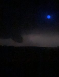
Funnel cloud near Lyman at around 8:35-p.m. (Photo courtesy Zach Ploen)
8:32-p.m. 6 miles E/SE of Oakland (Pott. County): Possible report of a tornado between Griswold and Oakland, from trained spotter.
8:27-p.m. 5 miles SW of Randolph (Fremont County): Tornado confirmed by video feed
8:22-p.m. Lewis, IA Quarter-sized hail (1″ dia) reported by Fire/Rescue personnel
8:21-p.m. 3 miles S. of Tabor (Fremont County): Storm chaser reported a tornado
8:16-p.m. 4 miles N. of Thurman (Fremont Co.): golf-ball size hail (1.75″) observed by a trained storm spotter
7:44-p.m. 2 miles NW of McClelland (Pott. County): reports of hail estimated at 4-inches in diameter (softball size)

