


Multiple tornadoes hit SW Iowa, with widespread wind damage in Storm Lake
April 18th, 2025 by Ric Hanson
(Radio Iowa) – While parts of southwest Iowa were dotted with tornadoes Thursday night, perhaps the worst damage in Iowa from the severe weather in the past day happened early this (Friday) morning in the northwest Iowa town of Storm Lake. Aimee Barritt, the Buena Vista County emergency management coordinator, says thousands of MidAmerican Energy customers in Storm Lake are without power after a severe thunderstorm hit about 1 A-M. “They have several power poles that are down at this point in time,” Barritt says. “This could change, but they’re telling us it’s going to be about 8 PM before power is restored. That’s their best estimate right now. They have a lot of work to do to do that.”
The Storm Lake Police Department is releasing a series of photos showing toppled concrete walls, flipped semis, and heavy damage to apartment buildings and stores. “In the city of Storm Lake, there’s lots of power lines down,” Barritt says. 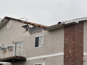

 (Photos: Storm Lake PD Facebook page)
“We’ve seen businesses with their roofs ripped off, there have been some gas leaks and there’s been a lot of debris and downed power lines on the road.” She recommends residents who can stay home from work or school to do exactly that as the roads are covered with debris and power lines. National Weather Service meteorologist Craig Cogil says severe weather also hit southwest Iowa last night. “There were a few tornadoes that were produced there. Haven’t heard a lot about damage with that as of yet, but certainly they did do some impacts in that part of the state,” Cogil says. “Otherwise, we have seen other storms across northern Iowa that have produced up to golf ball-sized hail.”
The tornadoes were reported near towns including: Oakland, Essex, Randolph and Tabor. In south-central Iowa, Taylor County reported wind gusts of 76 miles an hour. That golf ball-sized hail was reported near towns including Hampton and Waverly. Cogil says the forecast calls for cooler, calmer weather today, but storms are likely to return on Easter Sunday. “Right now, looks like Saturday will be relatively pleasant, maybe a little bit cool, but overall pleasant,” he says. “We are seeing a storm system move up this way on Sunday with rain over spreading the area by Sunday afternoon and continuing Sunday night. Should be some generous rainfall for much of the state, anywhere from three-quarters of an inch to an inch and a half.”
Keep up with the changing forecast at weather.gov.

