


Forecast: Northern Iowa faces worst risk of severe weather today
April 28th, 2025 by Ric Hanson
(Radio Iowa) – Iowans are being warned to be prepared for foul weather later today (Monday) and into tonight. National Weather Service meteorologist Rod Donavon says severe thunderstorms are possible across a wide section of the state. “We have a moderate risk out across northern Iowa, which is generally along and north of Highway 20, that is where the greatest risk for severe weather is at, and the rest of the state’s generally in an enhanced risk,” Donavon says. “We’re expecting storms to develop here later this afternoon, especially across northern Iowa, with the threat for few tornadoes, in addition to large hail and damaging winds.”
If it seems like we’ve been having a lot of severe weather in recent weeks, he says you’re not imagining things. “It’s really typical for this time of year,” Donavon says. “Once we get into this more volatile weather pattern, which is typically that early spring portion of the year, where we have a lot of stronger systems move through, we can have some of these stronger to severe weather episodes across the Midwest.” 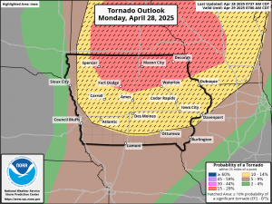
Iowa’s forecast also calls for broad temperature swings, with highs in the 80s likely for most of the state today, while the cold front arriving tonight should knock highs into the 60s tomorrow.

