


Burn Ban in effect for Montgomery County until further notice!
February 28th, 2025 by Ric Hanson
(Red Oak, Iowa) – The Montgomery County Emergency Management Agency late this (Friday) night, issued a BURN BAN, in effect immediately and until further notice! Emergency Management Coordinator Brian Hamman issued a statement on social media, saying the ban was necessary as a result of “Multiple, large and out of control field fires.”
Hamman said numerous fires were reported Friday (Feb. 28th), “As a direct result of Red Flag Conditions (Temperatures, High Winds & Low Relative Humidity) throughout the entire area. All fires originated from previously burnt brush piles from approximately 1-2 weeks ago, that had rekindled due to the strong sustained winds and eventually spread to dry adjoining grass and fields.”
Hamman said “While conditions two weeks ago were conducive to light and burn brush piles, we have quickly dried out due to the extreme warm up this week. Regardless of issuing an Open Burn Ban yesterday, today or tomorrow, it would not have changed the outcome today due to the extreme weather conditions. This is why we stress the importance of monitoring these piles for several weeks after they have burnt or request that once they are burnt, to please bury them or put soil on top.
“A special thanks,” He said, ” goes out to the US National Weather Service Omaha/Valley Nebraska for monitoring the fire trends today and quickly alerting us of wildfire detections via satellite, they were able to detect (5) fires prior to them being reported to 9-1-1.
“Another special thanks goes out to all the area farmers who quickly responded to all the different fires today with tractors & discs as well as all of our responding fire departments. Most all have fulltime jobs and are volunteers who give up their time to help when called upon.
“Lastly,” Hamman said, “A special thank you to Montgomery County 911 and all the area dispatchers who had a difficult day with all of the fires. At one point, we had (4) active field fires within Montgomery County ongoing. They fielded numerous calls and answered all radio traffic without hesitation and with the upmost professionalism.”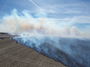


(Images are from the MCEMA Facebook page)
A brief list of each fire is listed below:
(1) At 11:30am, Montgomery Co EMA was notified of a wildfire detection via US National Weather Service Omaha/Valley Nebraska satellite radar in the area of US HWY 71 x US HWY 34. Montgomery County 911 received a 9-1-1 call shortly after reporting a field fire in the area of 220th x T Ave and fire departments were dispatched. The fire quickly grew out of control, jumped the road and was eventually contained with fire suppression units and tractors & discs. Crews were on scene for roughly 2 hours.
1 minor injury reported.
Origin of Cause: Previously lit burn pile. Estimated 45 acres burned.
Responding Agencies:
Villisca FD
Stanton Fire and Rescue Department
Red Oak Fire Department
Corning Iowa Fire Department
Montgomery County Emergency Management Agency
Montgomery County Sheriff’s Office – Red Oak, Iowa
Montgomery County 911
(3) Tractors & Discs
(2) At 1:08pm, Montgomery County 911 received a report of a small field fire in the area of 230th x C Ave southwest of Red Oak. Fire crews from the initial fire were released and responded as well as surrounding county mutual aid partners. The fire was quickly contained by a tractor and disc and with the first arriving fire units.
No injuries reported.
Origin of Cause: Previously lit burn pile.
Responding Agencies:
Red Oak Fire Department
Stanton Fire and Rescue Department
Emerson Volunteer Fire/Rescue Association Inc.
Essex Fire Rescue
Montgomery County Emergency Management Agency
Montgomery County 911
(3) At 2:01pm, Montgomery Co EMA was notified of another wildfire detection via US National Weather Service Omaha/Valley Nebraska satellite radar in the area of US HWY 48 x H Ave. Fire crews from the second fire were released and dispatched to the scene as well as additional mutual aid partners. Once initial crews arrived on scene, a fast-moving field fire was ongoing and additional out of county mutual aid resources were requested along with several area farmers with tractors & discs. Fire crews remained on scene for roughly 6 hours at this incident scene due to numerous piles of debris smoldering.
1 minor injury reported.
Origin of Cause: Previously lit burn piles. Estimated 150 acres burned.
Responding Agencies:
Red Oak Fire Department
Elliott FD
Stanton Fire and Rescue Department
Grant FD
Griswold Fire & Rescue
Carson Fire and Rescue
Macedonia FD
Clarinda FD
Numerous Tractor & Discs
(4) At 2:48pm, Montgomery Co EMA was notified of an additional wildfire detection via US National Weather Service Omaha/Valley Nebraska satellite radar in the area 110th x O Ave. Mutual aid crews responding to the HWY 48 x 110th fire were diverted and found an ongoing field fire in the area of 155th x Pine Ave. A tractor and disc was already deployed in the field assisting to create a fire break and out of county mutual aid partners were requested due to the large ongoing fire west of Elliott. Crews remained on scene for roughly 90 minutes.
No injuries reported.
Origin of Cause: Previously lit burn pile.
Responding Agencies:
Grant FD
Stanton Fire and Rescue Department
Villisca FD
Essex Fire Rescue
Clarinda FD
(1) Tractor and Disc
(5) At 3:18pm, Montgomery Co EMA was notified of an additional wildfire detection via US National Weather Service Omaha/Valley Nebraska satellite radar in the area of 270th and O Ave. Montgomery County 911 also took a call reporting this field fire and fire crews that were enroute to the previous fire were redirected and quickly contained the field fire with additional assistance from tractor & discs that were on scene or arrived shortly after. Crews were on scene for 1 hour.
No injuries reported.
Origin of Cause: Previously lit burn pile.
Responding Agencies:
Stanton Fire and Rescue Department
Villisca FD
Clarinda FD
(3) Tractor and Discs
(6) At 3:38pm, Montgomery Co EMA was notified of an additional wildfire detection via US National Weather Service Omaha/Valley Nebraska via satellite radar in the area of 110th x C Ave. Smoke was quickly visible at the HWY 48 x 110th fire and out of county mutual aid was requested as there were no available fire units within Montgomery County due to numerous ongoing field fires. Some units were able to be released from the HWY 48 x 110th fire to aid the out of county mutual aid resources and additional tractor & discs were called or responded directly to the scene. Crews were on scene for 2 hours.
No injuries reported.
Origin of Cause: Previously lit burn pile.
Responding Agencies:
Red Oak Fire Department
Griswold Fire & Rescue
Carson Fire and Rescue
Macedonia FD
Oakland Fire and Rescue
Henderson FD
Clarinda FD
Numerous Tractor & Discs
Other agencies providing assistance during those incidents:
Mills County Emergency Management Agency
Pottawattamie County Emergency Management
Page County Iowa Emergency Management \ E 911
Cass County Iowa Emergency Management Agency
Cass County 911 Center
