


Record highs possible today in the 70s, with wind chills tomorrow night below zero
February 26th, 2024 by Ric Hanson
(Radio Iowa) – A Red Flag warning is posted today (Monday) for most of Iowa and residents are warned not to do any open burning, as vegetation is very dry and winds will be gusting. Meteorologist Kristy Carter, at the National Weather Service, says high temperatures may climb into record or near-record territory in the 60s and 70s this afternoon. “We’re even going to be approaching the all-time February record high at some locations,” Carter says. “We’re going to combine that with some extreme fire danger as well. So that warmth with those strong winds, it’s going to lead to those extreme fire weather conditions, so certainly burning is not recommended today.” She says any fires that are set could quickly spread and burn out of control.
A big turnaround in temperatures is coming as forecasters say we’ll see lows across Iowa tomorrow night in the single digits and teens with snow possible. “Our temperatures are going to drop drastically through the day,” Carter says. “We’ll start warm, but by the afternoon into evening, temperatures are going to plummet. Our winds are also going to increase as well, so that’s going to send our wind chills down toward zero or below zero even by Wednesday morning.” Carter says the mid-week cold snap won’t last long with a return to warmer temperatures to welcome the first weekend of March.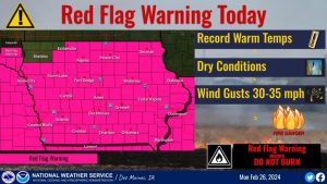
“On Wednesday, we’ll actually be closer to typical highs for the month of February in the mid 20s to mid 30s, but that will be very short lived,” Carter says. “We’re heading into the 50s by Thursday and then we’ll be approaching records again by the weekend.” The first day of Spring is March 19th.

