


Iowa Drought Monitor shows degradation in conditions, especially in NW Iowa
July 29th, 2022 by Ric Hanson
DES MOINES, Iowa — Iowa’s warm, dry weather has worsened the drought situation, while in states to the south, too much rain is the problem. That’s according to the latest Iowa Drought Monitor map which was released Thursday morning. The map shows over 56% of the state in abnormally dry conditions or some level of drought. That’s an increase of almost 10 percent. The hardest hit area is still northwestern Iowa. Extreme drought conditions, shown in red, have now extended into four counties there.
The Drought Monitor summary says “The Midwest saw a mix of degradations and improvements in the Drought Monitor this week, after weather was highly variable across the region. Hot and dry weather covered south-central and southwest Missouri, where flash drought continued to intensify and agricultural problems continued as a result.” Heavy rain fell in two areas, one from southeast of Kansas City to southeast Missouri, and a second in central, eastern, and northeast Missouri. The latter caused flash flooding in the St. Louis area and a record one-day rainfall at St. Louis Lambert Airport.” 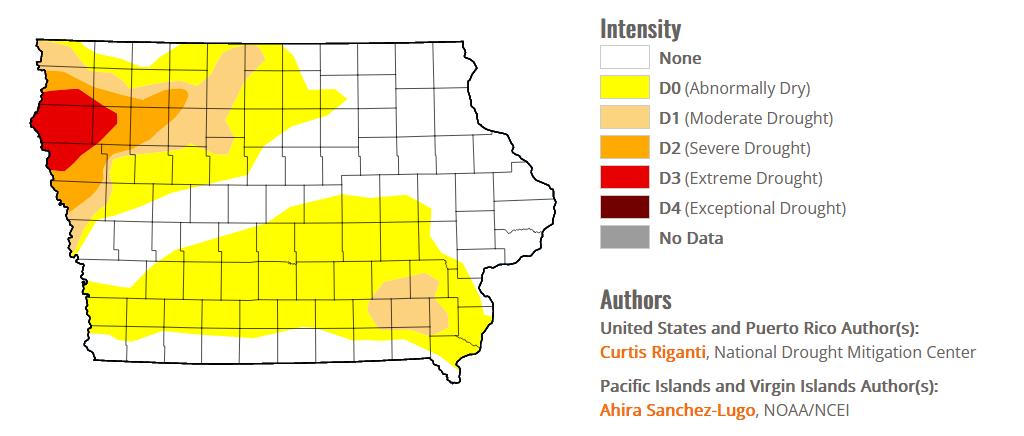 (click on the image to the right to enlarge)
Improvements to the drought situation occurred in parts of northeast Illinois, though heavier rains missed the severe drought area centered near Champaign. Drought expansion paused this week in the Michigan Lower Peninsula where widespread rain fell. Localized improvements were made in parts of Indiana, Ohio, and Kentucky where short-term conditions improved due to heavy rainfall. A mix of improvements and degradations occurred in Minnesota and Wisconsin around areas where heavier rain fell. Soil moisture deficits continued to mount in far northern Wisconsin, where moderate drought developed.
The latest 10-day forecast shows little chance for rain in Iowa.

