


(Update) Winter Weather Advisory
February 22nd, 2022 by Ric Hanson
343 AM CST Tue Feb 22 2022
.A long duration of mainly light wintry precipitation will continue to impact Iowa this morning. The wintry mix is expected
to transition to snow north by this (Tuesday) morning in northern areas and freezing drizzle may continue through portions of central and southern Iowa. The morning commute may be affected for many locations due to either snow covered or icy roads, especially if left untreated.
Sac-Crawford-Carroll-Audubon-Cass-Adams and Taylor Counties: A WINTER WEATHER ADVISORY IS IN EFFECT UNTIL 9 AM today for mixed precipitation expected. Total snow accumulations of less than one inch and a light glaze up to a few hundredths of an inch of ice.
Guthrie-Dallas-Adair-Madison-Union-Ringgold Counties: WINTER WEATHER ADVISORY NOW IN EFFECT UNTIL NOON today. 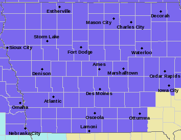
Monona-Harrison-Shelby-Pottawattamie-Mills Counties:
…WINTER WEATHER ADVISORY NOW IN EFFECT UNTIL NOON TODAY…
…WIND CHILL ADVISORY IN EFFECT FROM 6 PM THIS EVENING TO NOON CST WEDNESDAY…
* WHAT…For the Winter Weather Advisory, mixed precipitation. Additional snow accumulations of up to one inch and ice
accumulations of a light glaze. Winds gusting as high as 40 mph. For the Wind Chill Advisory, very cold wind chills
expected. Wind chills as low as 30 below zero.
* IMPACTS…Plan on slippery walkways and road conditions. The hazardous conditions could impact the morning commute.
PRECAUTIONARY/PREPAREDNESS ACTIONS…
Slow down and use caution while traveling. For the latest travel conditions, check the Iowa 5 1 1 app or dial 5 1 1.

