


Iowa Crop Progress and Condition Report
August 23rd, 2021 by Ric Hanson
DES MOINES, Iowa (Aug. 23, 2021) – Iowa Secretary of Agriculture Mike Naig commented Monday (today) on the Iowa Crop Progress and Condition report released by the USDA National Agricultural Statistics Service. The report is released weekly from April through November.
“After generally dry and pleasant weather during the Iowa State Fair, beneficial rain fell across much of northern Iowa over the last few days, providing some help to the extreme drought areas,” said Secretary Naig. “As we enter the final days of August, a more active weather pattern looks to bring additional chances of rainfall as soybeans are reaching a critical stage of development.”
The weekly report is also available on the USDA’s website at nass.usda.gov.
Crop Report
Despite spotty precipitation, Iowa’s farmers had 6.1 days suitable for fieldwork during the week ending August 22, 2021, according to the USDA, National Agricultural Statistics Service. Field activities included harvesting hay and oats. Producers were utilizing the release of CRP land for haying and grazing.
Topsoil moisture levels rated 24% very short, 40% short, 36% adequate and 0% surplus. Subsoil moisture levels rated 27% very short, 42% short, 31% adequate and 0% surplus. Northwest, Central and East Central Iowa had the lowest subsoil moisture levels in the State, with more than 80% rated short to very short.
Corn in or beyond the dough stage reached 90%, six days ahead of the 5-year average. Forty-seven percent of the corn crop has reached the dent stage or beyond, four days ahead of normal. There were scattered reports of corn reaching the mature stage. Some producers have begun chopping silage. Iowa’s corn condition rated 58% good to excellent. Soybeans setting pods reached 95%, eight days ahead of normal. Five percent of soybeans were coloring. There were a few reports of soybeans dropping leaves. Soybean condition was rated 61% good to excellent. Sudden death syndrome was observed in some soybean fields across the State. Oats harvested for grain reached 97%.
The third cutting of alfalfa hay reached 68% complete, three days ahead of the 5-year average. Both mites and army worms have been spotted in alfalfa and grass hay crops. Pasture condition was rated 31% good to excellent. Water for cows and calves on pasture has become an issue as some creeks and ponds dry up.
Weather Summary
Provided by Justin Glisan, Ph.D., State Climatologist, Iowa Department of Agriculture and Land Stewardship
Above-average temperatures were observed across most of Iowa during the reporting period with a cool down from a cold frontal passage late in the week. The statewide average temperature was 72.7 degrees, 0.7 degrees above normal. Though most of the week was dry, a large-scale weather system brought widespread rainfall across Iowa with above-normal totals approaching two inches in drought-stricken northern Iowa; much of southern Iowa reported only a few tenths of an inch of rainfall.
Sunshine and southeasterly winds led to pleasant conditions on Sunday (15th) afternoon. Partly cloudy skies remained overnight into Monday (16th) morning as a dome of high pressure dominated the weather pattern over the Midwest, lending to quiet conditions. Afternoon temperatures ranged from the low to mid 80s west to upper 70s east. Starry skies and a light southerly wind held temperatures in the upper 50s and low 60s into Tuesday (17th) with some clouds streaming into central Iowa. Daytime temperatures were on the rise with increasing southerly winds and humidity; mid to upper 80s were observed in western Iowa while eastern Iowa reported temperatures three to five degrees cooler. Hazy skies were observed into Wednesday (18th) as wildfire smoke filtered into the region. Daytime highs rose into the 80s with a few 90 degree readings under partly cloudy skies. Morning lows reported at 7:00 am on Thursday (19th) were unseasonably warm, generally in the mid to upper 60s, up to nine degrees above normal. Dew point temperatures in the upper 60s and low 70s combined with afternoon highs in the upper 80s led to very muggy conditions into the evening hours.
Light showers formed in western Iowa early on Friday (20th) before dissipating during the late morning hours. Southwesterly winds picked up through the afternoon as a cold front approached the state front from the west. Muggy conditions continued, which helped fire stronger thunderstorms in northwestern Iowa as the boundary entered the state. Some storms turned severe with a brief tornado reported near Sibley (Osceola County), causing some damage to trees and outbuildings. As the front swept across the state, measurable rainfall was observed at a majority of stations with general totals of a few tenths of inch over the state’s northern half. Numerous stations in north-central Iowa reported above 0.50 inch with nearly 30 stations measuring an inch or more. Pocahontas (Pocahontas County) reported 2.15 inches while Webster City (Hamilton County) observed 2.92 inches. Behind the front, cooler and more pleasant conditions were experienced on Saturday (21st) with sunny skies and a light northerly wind. Temperatures remained in the mid 70s to low 80s during the daytime hours and dropped into the 50s overnight into Sunday (22nd) morning.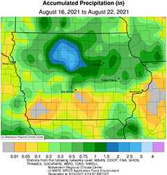
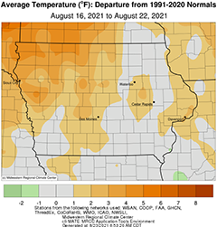
Weekly precipitation totals ranged from no accumulation at several southern Iowa stations to 3.26 inches at Webster City (Hamilton County). The statewide weekly average precipitation was 0.57 inch while the normal is 0.95 inch. Multiple stations observed the week’s high temperature of 92 degrees on the 20th, on average nine degrees above normal. Elkader (Clayton County) reported the week’s low temperature of 46 degrees on the 16th, 12 degrees below normal.

