


New Cass County Trails Map Available
October 9th, 2020 by Ric Hanson
If you’re looking to spend time outdoors enjoying fall weather, you might want to check out the new Cass County trails map found at www.AtlanticIowa.com. Cass County Wellness Coordinator Brigham Hoegh says printed copies of the Cass County trails map can be picked up at the Atlantic Area Chamber of Commerce, and will be distributed throughout the county this fall and next spring. Nishna Valley Trails sponsored the map, which was created in partnership with Healthy Cass County. The map, designed by Hotch Studios, highlights 12 different trail locations across county.
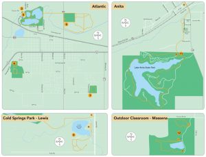
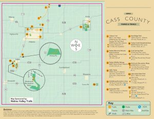 Cass County Naturalist Lora Kanning says “People ask about trails in Cass County, but we haven’t been able to give them a simple reference until now. This map does that. It tells you where the trails are, how long they are, if they are accessible, and if they are dirt, grass, gravel or paved. Additionally, we know the risk of transmitting COVID-19 is lower outdoors, so now is a fantastic time to spend more time on our trails.”
Nishna Valley Trails and Healthy Cass County, in cooperation with other area organizations, are developing a trail-needs survey that will be made available this fall with the goal of gaining input and feedback about how the Cass County Trail System can be improved. In the meantime, ideas for trail improvements may be submitted to Cass County Wellness Coordinator Brigham Hoegh at bhoegh@iastate.edu or 712-249-5870.
If your business or organization would like printed copies of the map, please contact Brigham Hoegh. For more information on local wellness events or resources, follow Healthy Cass County on Facebook @HealthyCassCounty.

