


Atlantic Parks and Rec Board hears about “Walkability” Maps
July 21st, 2020 by Ric Hanson
The City of Atlantic’s Parks and Recreation Department Board of Directors met Monday evening and heard from Parks and Rec Director Bryant Rasmussen, who told them the final stages of the City of Atlantic’s “Walkability” maps are being finalized. Rasmussen said the maps will show the locations of various forms of entertainment, shopping areas, as well as restaurants and other points of interest.
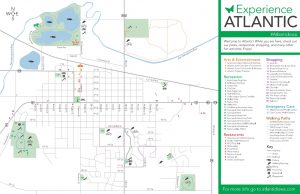
Walkability Map for the City of Atlantic.
He mentioned too, that they are looking to place a larger map outside of the Parks and Rec Building at Sunnyside Park; another large map at Schildberg Recreation Area (along with some brochures), and other map locations at City Park and at the Atlantic Area Chamber of Commerce.
Rasmussen told the Board also, that the big dock at the Schildberg Recreation Area is ready to be placed back in the water soon, and that the dock will be extended out about another 12 feet. You may recall, that flooding in March of 2019 ripped the cement mooring posts for the dock that held it place. Following the flood event, the dock was found on the shoreline.

