


SEVERE THUNDERSTORM WATCH until 10-p.m. (4/24)
April 24th, 2016 by Ric Hanson
225 PM CDT SUN APR 24 2016
THE SEVERE STORMS PREDICTION CENTER IN NORMAN, OK., HAS ISSUED SEVERE THUNDERSTORM WATCH 101 IS IN EFFECT UNTIL 1000 PM CDT
IOWA COUNTIES INCLUDED ARE
ADAIR ADAMS AUDUBON BUENA VISTA CALHOUN CARROLL CASS CHEROKEE CLAY CRAWFORD DICKINSON EMMET FREMONT GREENE GUTHRIE HARRISON IDA LYON MILLS MONONA MONTGOMERY O’BRIEN OSCEOLA PAGE PALO ALTO PLYMOUTH POCAHONTAS POTTAWATTAMIE SAC SHELBY SIOUX TAYLOR WOODBURY.
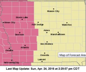
SEVERE THUNDERSTORM WATCH UNTIL 10-p.m (Counties in mauve)
PROBABILITY TABLE:
PROB OF 2 OR MORE TORNADOES : 20%
PROB OF 1 OR MORE STRONG /F2-F5/ TORNADOES : <02%
PROB OF 10 OR MORE SEVERE WIND EVENTS : 60%
PROB OF 1 OR MORE WIND EVENTS > 75 MPH : 30%
PROB OF 10 OR MORE SEVERE HAIL EVENTS : 90%
PROB OF 1 OR MORE HAIL EVENTS > 2 INCHES : 30%
PROB OF 6 OR MORE COMBINED SEVERE HAIL/WIND EVENTS : >95%
MAX HAIL /INCHES/ : 2.5
MAX WIND GUSTS SURFACE /MPH/ : 75
A Severe Thunderstorm Watch is issued by the National Weather Service when conditions are favorable for the development of severe thunderstorms in and close to the watch area.

