


1st Severe Weather Threat of the year is possible Thursday & Friday
March 4th, 2026 by Ric Hanson
(Des Moines, IA) – The National Weather Service says the first severe weather threat of the year is possible Thursday and Friday. Officials say the threat encompasses most of Iowa, with the first round of marginal, isolated severe storms coming late Thursday night (mainly after midnight) across western and central Iowa. The main feature of the storms will be penny- to half-dollar sized hail (.75-1.25″ in diameter), along with winds of up to 60-mph. 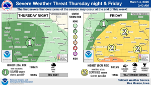
The second round of storms Friday evening brings a slight risk of damaging winds (50+mph), large hail and scattered tornadoes, with the threat area covering most of the State, with the exception of the northwest and northern tier counties, where there is a marginal risk of severe storms. The east/northeast parts of the State face the greatest risk of severe storms, according to the latest information.
Be sure to have multiple ways of being informed when storms threaten, including a weather radio, and prepare to take shelter when warnings are issued.

