


(Updated 3:07-a.m. 11/28) – The latest on Winter Storm Warnings, Watches & Advisories
November 28th, 2025 by Ric Hanson
Monona-Harrison-Shelby Counties…A WINTER STORM WARNING REMAINS IN EFFECT FROM NOON TODAY (FRIDAY) UNTIL MIDNIGHT (12-AM) SATURDAY.* WHAT…Heavy mixed precipitation expected. Total snow accumulations between 4 and 8 inches and ice accumulations around a light glaze. Winds gusting as high as 35 mph. Blowing snow will produce poor visibility.
Sac-Crawford-Carroll-Audubon-Guthrie-Dallas-Cass-Adair-Madison Counties…A WINTER STORM WARNING REMAINS IN EFFECT FROM 3 PM THIS AFTERNOON TO 6 AM CST SUNDAY.
* WHAT…Heavy snow expected. Total snow accumulations between 7 and 12 inches.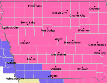
Pottawattamie-Mills-Montgomery-Fremont and Page Counties..A WINTER WEATHER ADVISORY IS IN EFFECT FROM 3 PM FRIDAY TO MIDNIGHT SATURDAY.
* WHAT…Heavy mixed precipitation possible. Total snow accumulations between 2 and 6 inches and ice accumulations around a light glaze possible. Winds could gust as high as 40 mph. Blowing snow will produce poor visibility.
Adams-Taylor and Ringgold Counties….A WINTER WEATHER ADVISORY IS IN EFFECT FROM 6 PM THIS EVENING TO 6 AM CST SUNDAY…
* WHAT…Mixed precipitation expected. Total snow accumulations between 2 and 6 inches and a light glaze of ice.
Union County…A WINTER STORM WARNING IS IN EFFECT FROM 6 PM FRIDAY UNTIL 6 AM SUNDAY.
* WHAT…Heavy snow expected. Total snow accumulations between 5 and 8 inches. A light glaze of freezing drizzle also possible.
IN ALL AREAS: Travel will be very difficult to impossible. Persons should delay all travel if possible. If travel is absolutely necessary, drive with extreme caution and be prepared for sudden changes in visibility. Leave plenty of room between you and the motorist ahead of you, and allow extra time to reach your destination. Avoid sudden braking or acceleration, and be especially cautious on hills or when making turns. Make sure your car is winterized and in good working order.

