
315 PM CDT MON AUG 5 2019

SEVERE THUNDERSTORM WATCH 554 IS IN EFFECT UNTIL 1100 PM CDT
FOR THE FOLLOWING LOCATIONS

   IOWA COUNTIES INCLUDED ARE

BLACK HAWK           BOONE               BREMER
BUTLER               CALHOUN             CARROLL
CERRO GORDO          CRAWFORD            EMMET
FRANKLIN             GREENE              GRUNDY
HAMILTON             HANCOCK             HARDIN
HUMBOLDT             KOSSUTH             MARSHALL
PALO ALTO            POCAHONTAS          SAC
STORY                TAMA                WEBSTER
WINNEBAGO            WORTH               WRIGHT
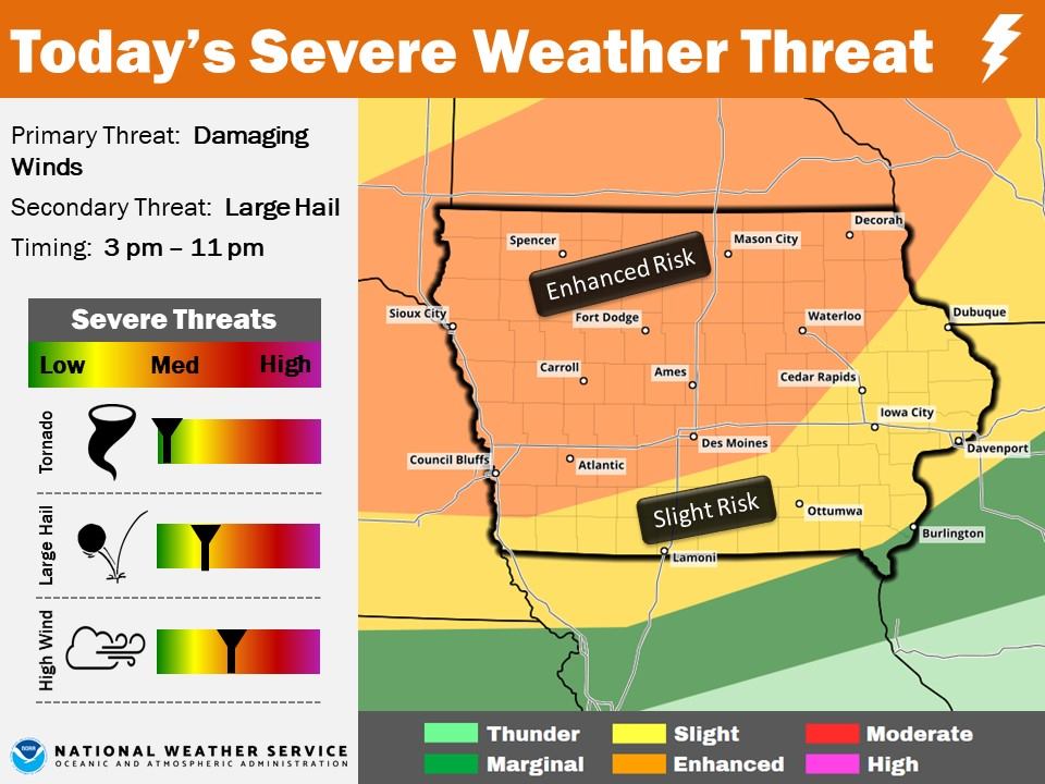
Click to enlarge the graphic
The National Weather Services report an enhanced risk for severe weather is forecast for mid-afternoon through mid-evening, today. Storms are expected to fire-up between 3-and 11-p.m. Damaging winds are the primary threat, with large hail a secondary threat. There may be periodic heavy rainfall, however the threat for flash flooding is low at this time- largely due to the lack of rainfall over the past few weeks.
If you have outdoor plans this afternoon/evening, especially from central to northern Iowa, make sure you monitor the weather forecast closely and have a place to seek safe shelter, should it be necessary. Also, make sure you have multiple ways to receive severe weather warnings.
Today: Partly cloudy w/scattered showers & thunderstorms possible later this afternoon. High 83.S @ 5-10. There is an enhanced risk for severe thunderstorms this afternoon through this evening. Damaging winds are the primary threat, with large hail as a secondary threat. Additionally, there may be brief periods of heavy rainfall.
Tonight: Scattered showers & thunderstorms. Low 68. NW @ 5-10.
Tomorrow: P/Cldy. High 83. NW @ 5-10.
Wednesday: P/Cldy w/scattered showers & thunderstorms possible. High 85.
Thursday: A chance of morning thundershowers; Becoming P/Cldy. High 83.
Yesterday’s High in Atlantic was 85. Our Low this morning 61. Last year on this date our High was 91 and the Low was 67. The record High in Atlantic on this date was 111 in 1918. The Record Low was 42 in 1978.
Today: Patchy fog before 9am. Otherwise, mostly sunny, with a high near 84. Calm wind becoming south 5 to 7 mph in the afternoon.
Tonight: Mostly clear, with a low around 65. South wind 3 to 6 mph.
Monday: A 40 percent chance of showers and thunderstorms, mainly after 4pm. Partly sunny, with a high near 85. Southwest wind 5 to 11 mph.
Monday Night: A 40 percent chance of showers and thunderstorms. Mostly cloudy, with a low around 65. Southwest wind around 5 mph becoming calm in the evening. New rainfall amounts between a tenth and quarter of an inch, except higher amounts possible in thunderstorms.
Tuesday: Mostly sunny, with a high near 83. Calm wind becoming northwest around 5 mph.
Wednesday: A 20 percent chance of showers and thunderstorms. Partly sunny, with a high near 84.
Today: Partly cloudy to Cloudy w/isolated showers possible this morning. High 83.S @ 5-10.
Tonight: P/Cldy. Low 65.
Tomorrow: P/Cldy. High 85. S @ 5-10.
Monday: P/Cldy w/isolated thunderstorms possible, late. High 87.
Tuesday: A chance of morning thundershowers. Becoming P/Sunny. High 83.
Yesterday’s High in Atlantic was 83. Our Low this morning 60. Last year on this date our High was 90 and the Low was 68. The record High in Atlantic on this date was 107 in 1930. The Record Low was 42 in 1907.
(Radio Iowa) — Forecasters say much of Iowa will have sunny skies and moderate summertime temperatures through the weekend, but the months ahead may be much cooler and wetter. State climatologist Justin Glisan says the just-ended month of July was a bit hotter than usual and we didn’t see much in the way of rainfall. “We had a drier-than-normal month across much of the state with the northern counties, along the South Dakota border and the Minnesota border with above-average precipitation,” Glisan says. “But as a whole, we were about three-and-a-half inches across the state which is a little less than an inch below normal.”
As for July temperatures, the state averaged just over 75-degrees, which is almost two-degrees warmer than normal. Looking ahead, the month of August promises to be colder than usual. “Our climate outlooks were at above-average chances of below-normal temperatures across the state,” Glisan says. “Looking at the western third of Iowa, we’re trending a little bit above-average for wetness, so we should expect a little more rainfall in the western part of the state and near-normal conditions for the rest of Iowa.”
Iowans may recall that August of 2018 was the start of one of the wettest autumns in state history. Glisan says the fall ahead may still go either way. “What we’re seeing in the climate signals for the next three months are a slightly-above average chance of precipitation across the western part of the state and then equal chances in eastern Iowa,” Glisan says. “We’re a little too far out to get into October and November. Those forecasts will come in the middle of August.”
Last fall was Iowa’s third-wettest on record, but for now, he says there are no “gully washers” in the immediate forecast.
Today: Areas of morning fog; Partly cloudy to Cloudy w/isolated showers possible late this afternoon. High around 80..SE @ 10-15.
Tonight: P/Cldy to Cldy w/isolated showers. Low 67. SE @ 5.
Tomorrow: P/Cldy. High 84. S @ 5-10.
Sunday: P/Cldy. High 85.
Monday: P/Cldy w/a chance of thundershowers, late. High 85.
Yesterday’s High in Atlantic was 83. Our Low this morning 60. Last year on this date our High was 84 and the Low was 57. The record High in Atlantic on this date was 1043 in 1930. The Record Low was 42 in 1907.
Weather data for the month of July here in Atlantic show it was just slightly cooler and much wetter than normal. Data compiled here at the KJAN studios (The official National Weather Service reporting site for Atlantic), indicate the average High last month was 85.1 degrees, which was just seven-tenths of a degree cooler than the norm (85.8). The average Low of 63.7-degrees was slightly warmer than the norm (63.1). Rainfall for the month amounted to 5.72 inches, as compared to the typical 4.62-inches.
During the month of August in Atlantic, the High normally averages out to be 83.3-degrees, and the average Low is typically 60.6-degrees. Rainfall for the month normally amounts to around 3.88-inches.
Today: Areas of morning fog; Partly cloudy to Cloudy w/isolated showers & thunderstorms this morning & later this afternoon. High 78.SE @ 10-15.
Tonight: P/Cldy to Cldy w/scattered showers. Low 65. SE @ 5.
Tomorrow: P/Cldy to Cldy w/scattered showers. High near 80. SE @ 10-15.
Saturday: P/Cldy. High 84.
Sunday: P/Cldy. High 85.
Yesterday’s High in Atlantic was 68. Our Low was 61. We received 1.32” rain Wednesday, in Atlantic. Last year on this date our High was 85 and the Low was 53. The record High in Atlantic on this date was 102 in 1897. The Record Low was 42 in 1898.


