140 PM CDT SAT APR 27 2024
TORNADO WATCH 147 IS IN EFFECT UNTIL 900 PM CDT FOR THE FOLLOWING LOCATIONS
IOWA COUNTIES INCLUDED ARE: ADAMS APPANOOSE CLARKE DAVIS DECATUR LUCAS MADISON MAHASKA MARION MONROE RINGGOLD TAYLOR UNION WAPELLO WARREN WAYNE.
* Primary threats include…
A few tornadoes likely with a couple intense tornadoes possible Scattered large hail and isolated very large hail events to 2
inches in diameter likely Scattered damaging winds likely with isolated significant gusts to 75 mph possible
SUMMARY…Thunderstorms will continue to develop this afternoon along a surface boundary lying across northern Missouri and southern Iowa. Large hail and damaging winds are possible, along with a few tornadoes in the strongest cells.
The tornado watch area is approximately along and 45 statute miles north and south of a line from 35 miles west of Saint Joseph MO to 30 miles south of Ottumwa IA.
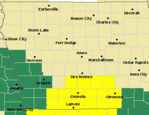
Tornado Watch for Counties in yellow. Flood Watch for counties in green.
PRECAUTIONARY/PREPAREDNESS ACTIONS…
REMEMBER…A Tornado Watch means conditions are favorable for tornadoes and severe thunderstorms in and close to the watch area. Persons in these areas should be on the lookout for threatening weather conditions and listen for later statements and possible warnings.