


Pottawattamie, Harrison, and Mills Counties Prepare for another Round of Potential Flooding
September 30th, 2019 by Ric Hanson
COUNCIL BLUFFS, Iowa – This (Monday) morning, the National Weather Service Missouri Basin River Forecast Center in Pleasant Hill, Missouri released forecast data which places the Missouri River and several tributary rivers back in higher levels of flood stage throughout Pottawattamie, Harrison & Mills counties. Many of the river forecasts are showing significant increases, primarily because the current modeling uses rain projections for the next 72 hours of potential precipitation. Typical models only account for 24 hours of projected rainfall.
Emergency Managers for the three counties, in consultation with the River Forecast Center, remind residents that the current projections should be viewed as one plausible scenario for the upcoming rainfall event. “What we do know is that over the next 72 hours we are going to see a heavy precipitation event of 4 to 5 inches of rain somewhere in the region; what we don’t know for certain is where it will fall,” commented Doug Reed, Director of Emergency Management for Pottawattamie County.
The current 72 hour rainfall predictions estimate a heavy band of rain, upwards of six inches, falling in a northeasterly line from near Columbus, NE through Onawa and Northwest Iowa. The heaviest rains in this system falling in this area would have a profound impact on the Missouri and some of its tributaries.
Emergency Managers urge residents to interpret the latest flood prediction in a measured manner based on the high degree of uncertainty of where the heaviest rains will fall. “We want people to be aware of the possibility of another round of significant flooding, but also aware that it is not certain we will see water at those levels until we get closer to the rain event,” commented Larry Hurst, Emergency Management Director for Mills County. “Residents should use all available information to take actions they feel necessary, keeping in mind that this forecast is certain to change as we enter the 72 hour window and have better forecast models to work from,” stated Larry Oliver, Harrison County Emergency Management/911 Director.
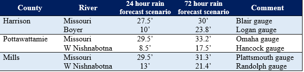
Below is a table of anticipated river levels based on a 24 hour prediction as well as the 72 hour prediction should the existing weather forecast have no changes over the next few days:
In addition to the river threats, emergency managers do want residents to recognize that we are expected to see in our counties a 2-3” rain event in already wet conditions. This could lead to interior flash flooding events along rural creeks and streams as well as urban flash flooding in municipal areas where drainage issues are typical.
All residents are encouraged to pay close attention to updated rain and river forecasts this week. Forecast details and river predictions will be changing through the next few days. Residents in all three counties can sign up for weather alerts and local emergency notifications below:
Pottawattamie County Pottawattamie Alert https://entry.inspironlogistics.com/pottawattamie_ia/wens.cfm Harrison County Citizen Alert System https://member.everbridge.net/index/892807736721501#/login Mills County Mills Alert https://entry.inspironlogistics.com/Mills_ia/wens.cfm

