


(2/23/17) Winter Weather Advisory, Winter Storm Warning & Blizzard Warning
February 23rd, 2017 by Ric Hanson
The National Weather Service has updated the status of their Winter weather-related advisories and warnings. A Winter Weather Advisory for snow and blowing snow is now in effect from 6-a.m. Friday until Midnight, for Crawford, Carroll, Audubon, Guthrie, Cass Shelby, Pottawattamie and Mills Counties. And, a Winter Storm Warning is in effect from 6-a.m. Friday until midnight, for Monona and Harrison Counties. Further north (the northern 4 tiers of counties), a Blizzard Warning is in effect from 6-p.m. today (Thursday) through early Saturday morning.
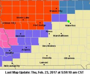
Blizzard Warning for counties in bright red; Winter Storm Warning for counties in pink; Winter Weather Advisory for counties in purple.
* TIMING…Rain will transition to snow by early Friday afternoon with winds increasing through the day on Friday. The precipitation and wind are expected to persist into early Saturday morning.
* STORM TOTAL SNOW ACCUMULATIONS…3 to 7 inches.
* WINDS/VISIBILITY…Winds becoming north to northwesterly at 20 to 30 mph with gusts over 40 mph. Visibility will be reduced to one half mile or less during periods of heavier snow and wind.
* IMPACTS…Roadways will become snow covered and blowing snow will reduce visibility creating hazardous travel conditions Friday into early Saturday morning.
PRECAUTIONARY/PREPAREDNESS ACTIONS…
A Winter Weather Advisory for blowing snow means that visibilities will be limited due to strong winds blowing snow around. Use caution when traveling, especially in open areas.

