


NWS says be prepared for all types of severe weather today
June 30th, 2014 by Ric Hanson
Officials with the National Service in Des Moines are warning Iowans to be prepared “For all modes of severe weather” across the state today. In their mid-morning web briefing, the Weather Service said tornadoes, large hail and damaging winds have occurred and can be expected to continue. The best threat for severe weather will be across the southern two-thirds of the state, with “Multiple waves” of severe weather possible.
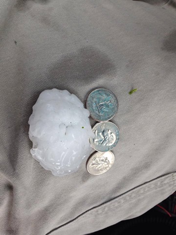
3″ diameter hail in Harlan this morning. (Shelby County EMA photo)
In addition, heavy rainfall with areas of localized flooding is possible from mid-day through tonight. There is a 10-percent or greater chance of tornadoes today across western and central Iowa. The tornadoes may rate from EF-2 or higher on the Fujita scale, meaning winds could be well in excess of 115-miles per hour. An EF-2 tornado can cause considerable damage, with roofs torn off frame houses; mobile homes demolished; boxcars overturned; large trees snapped or uprooted; light-object missiles generated; cars lifted off ground.
The greatest damaging wind threat will be over central and eastern Iowa. Most of central and western Iowa will also be impacted by large, damaging hail today. Stay tuned to KJAN for continued weather coverage.

