


May 8th, 2014 by Ric Hanson
Large hail, damaging winds, and tornadoes are possible across much of Iowa today. National Weather Service Meteorologist Kevin Skow says virtually the entire state is under the gun. “The greatest threat for severe weather extends across most of the central third of Iowa, with the greatest threat for tornadoes and large hail across northern Iowa, and then primarily large hail and some damaging winds across southern Iowa,” Skow says.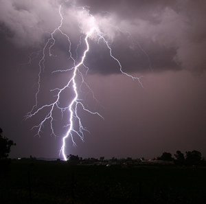
The storms are expected to pop up this afternoon. “It looks like the bulk of the severe weather…will be developing around 2 to 3 p.m. across west-central Iowa and then shifting to the east as the afternoon and evening progress onward,” Skow says.
Storms that rumbled through western and northwest Iowa Wednesday night dropped one-inch diameter hail 8-miles south of Logan in Harrison County, at around 8:53-p.m., and featured winds of up to 55-miles per hour. The storms moved into Carroll County, where winds along Highway 30 were clocked at 64-miles per hour (by the Iowa DOT’s weather station), at around 10:30-p.m.. And, in Sac County, golf ball-sized hail fell just north/northwest of Lytton at around 10-p.m.
High temperatures today are forecast to be between 75 and 85 degrees. Skow says it’ll cool off more tomorrow (Friday). “We’re looking at generally cooler temperatures with a dry start to the weekend, but it looks like showers and thunderstorms return to the forecast on Sunday,” Skow says.
High temperatures on Friday, Saturday, and Sunday are expected to be mainly in the 60s and 70s.
(Radio Iowa)
