930 PM CDT SUN MAY 31 2026
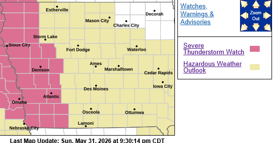
SEVERE THUNDERSTORM WATCH 259 IS IN EFFECT UNTIL 300 AM CDT FOR THE FOLLOWING LOCATIONS… IOWA COUNTIES INCLUDED ARE:
ADAMS AUDUBON CARROLL CASS CRAWFORD FREMONT HARRISON MILLS MONONA MONTGOMERY PAGE POTTAWATTAMIE SAC SHELBY and TAYLOR.
* Primary threats include…
Scattered large hail and isolated very large hail events to 2 inches in diameter possible
Isolated damaging wind gusts to 70 mph possible
SUMMARY…Strong to severe thunderstorms may develop through late evening into the overnight, with large hail as the primary hazard within an unstable environment.
PRECAUTIONARY/PREPAREDNESS ACTIONS…
REMEMBER…A Severe Thunderstorm Watch means conditions are favorable for severe thunderstorms in and close to the watch area. Persons in these areas should be on the lookout for threatening weather conditions and listen for later statements and