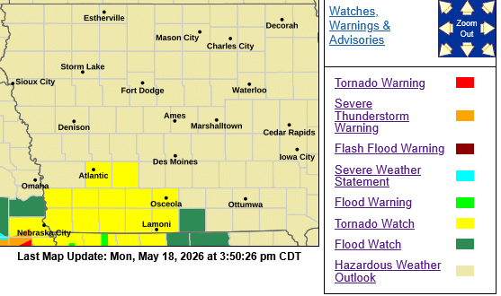
TORNADO WATCH 225 IS IN EFFECT UNTIL 1000 PM CDT FOR THE
FOLLOWING LOCATIONS – IOWA COUNTIES INCLUDED ARE
ADAIR ADAMS CASS
CLARKE DECATUR FREMONT
MILLS MONTGOMERY PAGE
RINGGOLD TAYLOR UNION
 The NWS Storm Prediction Center has issued a

   * Tornado Watch for portions of
     Southwest Iowa
     Northeast Kansas
     Northwest Missouri

   * Effective this Monday afternoon and evening from 350 PM until
     1000 PM CDT.

   * Primary threats include...
     A few tornadoes and a couple intense tornadoes likely
     Widespread damaging winds and isolated significant gusts to 80
       mph likely
     Scattered large hail and isolated very large hail events to 2
       inches in diameter likely

   SUMMARY...Intense supercell thunderstorms over northeast Kansas and
   southeast Nebraska will continue eastward this evening into the
   watch area.  Large hail, damaging winds, and tornadoes will all be
   possible.

   PRECAUTIONARY/PREPAREDNESS ACTIONS...

   REMEMBER...A Tornado Watch means conditions are favorable for
   tornadoes and severe thunderstorms in and close to the watch
   area. Persons in these areas should be on the lookout for
   threatening weather conditions and listen for later statements
   and possible warnings.