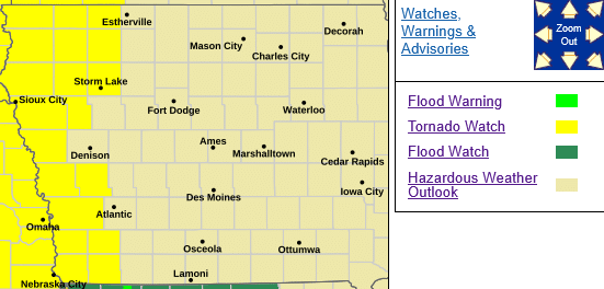
TORNADO WATCH 214 IS IN EFFECT UNTIL 1100 PM CDT FOR THE FOLLOWING LOCATIONS…IOWA COUNTIES INCLUDED ARE: FREMONT HARRISON MILLS MONTGOMERY PAGE POTTAWATTAMIE AND SHELBY.
* Primary threats include…
- A few tornadoes likely with a couple intense tornadoes possible
- Scattered damaging winds likely with isolated significant gusts to 75 mph possible
- Scattered large hail likely with isolated very large hail events to 3 inches in diameter possible
SUMMARY…The airmass ahead of the approaching cold front from southeast Nebraska into north-central/northeast Kansas continues to destabilize amid strong heating and low-level moisture advection. Discrete thunderstorm development is possible in the warm sector ahead of this cold front, with the environmental conditions supportive of supercells capable of all hazards, including very large hail to 3″ in diameter and strong tornadoes.
Thunderstorm development is possible along the front as well, with large hail and damaging gusts as the primary hazards with these storms. The tornado watch area is approximately along and 95 statute miles east and west of a line from 10 miles north northeast of Columbus NE to 25 miles south of Concordia KS.
PRECAUTIONARY/PREPAREDNESS ACTIONS…
REMEMBER…A Tornado Watch means conditions are favorable for tornadoes and severe thunderstorms in and close to the watch area. Persons in these areas should be on the lookout for threatening weather conditions and listen for later statements and possible warnings.