Tornado Watch Number 210
NWS Storm Prediction Center Norman OK
440 PM CDT Sat May 16 2026
The NWS Storm Prediction Center has issued a Tornado Watch for portions of Southern into Southwest Iowa and Northern Missouri Effective this Saturday afternoon and evening from 440 PM until 1100 PM CDT.
AREA COUNTIES INCLUDED: ADAIR; ADAMS; CASS; FREMONT; MADISON; MILLS; MONTGOMERY; PAGE; RINGGOLD; TAYLOR AND UNION.
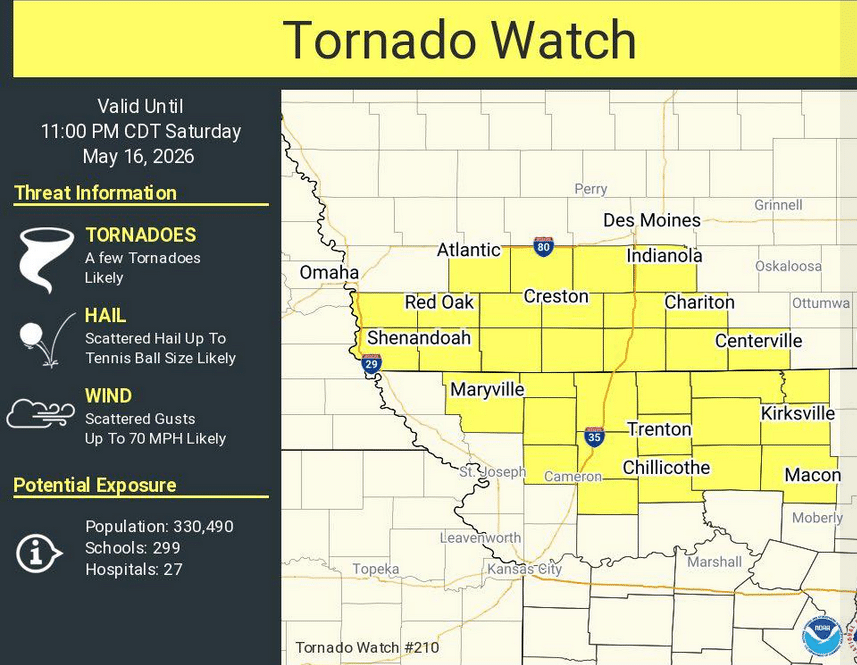
* Primary threats include…
A few tornadoes likely with a couple intense tornadoes possible
Scattered large hail and isolated very large hail events to 2.5
inches in diameter likely
Scattered damaging wind gusts to 70 mph likely
SUMMARY…Scattered supercells are forecast to continue to develop and intensify through the late afternoon and evening. Large to very large hail will be possible with the supercells. The more intense supercells will also be capable of a tornado risk through the mid to late evening before a gradual congealing of storms and clustering gradually lessens the overall severe risk. The threat for severe gusts may increase as storms grow upscale into one or more clusters later this evening.
PRECAUTIONARY/PREPAREDNESS ACTIONS…
REMEMBER…A Tornado Watch means conditions are favorable for
tornadoes and severe thunderstorms in and close to the watch area. Persons in these areas should be on the lookout for threatening weather conditions and listen for later statements and possible warnings.