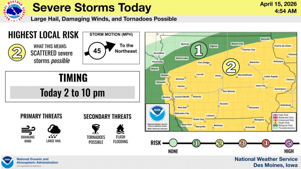
In the latest Severe Weather Briefing (4:54-a.m., 4/15/26), the National Weather Service said severe storms are possible today, with the primary threats being tornadoes and flash flooding. The highest risk for scattered, severe storms (large hail, damaging winds and possible tornadoes), is from 2-until 10-p.m., south of a line from Decorah to Onawa, with the risk for Atlantic & the area from around 2:30-until 9-p.m. The storms will be moving to the northeast at around 45 mph once they begin to form. https://www.weather.gov/dmx/weatherstory
The primary threats are from damaging winds (60-to 70-mph) and large hail (Greater than 1″ in diameter is possible with any storms; there is also the potential for 2″ diameter hail or larger), with secondary threats from possible tornadoes and flash flooding creating within-bank river/stream rises and isolated minor river flooding. Low-end flash flooding is possible. The greatest risk of flooding is over eastern Iowa, from Mason City to points east and south, with moderate to heavy rain amounting to more than 2-inches in some areas. The higher risk for tornadoes is near the Interstate 80 corridor, with EF2 strength tornadoes possible.
Tomorrow (Friday), there is a slight risk of severe weather (2-out of 5-chance) in an area from Omaha to Mason City and Decorah, and an enhanced risk from a line roughly east of a line from Red Oak to Ames and Charles City. The timing for those storms will again be in the afternoon and evening, as they move to the northeast. Large hail, damaging winds and isolated tornadoes will be possible.
Be sure to have MULTIPLE ways to receive weather warnings these next couple of days, including a NOAA Weather Radio, by signing-up for Alert Iowa wireless text notifications and emergency alerts, radio and television stations, and listen for outdoor warning sirens when severe weather threatens your area.