
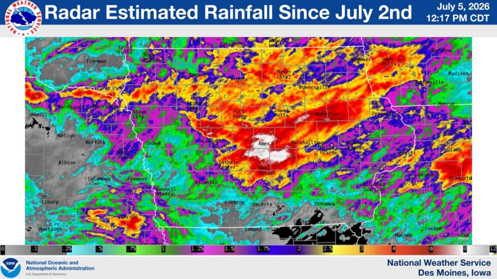
(Radio Iowa) – Some Iowans are still dealing with the aftermath of flash flooding in central and eastern Iowa that struck during the Independence Day holiday period. Grundy Center got five-and-a-half inches of rain Thursday night into Friday morning — and the National Weather Services estimates an area that includes Ankeny and Ames got between eight and 12 inches of rain from July 2nd through the morning of the 4th. Andrew Ansorge is a meteorologist at the National Weather Service office in Johnston.
“As people walked outside, they would notice just how humid it was, so it was very moisture laden and we had very weak winds throughout the atmosphere,” Ansorge says, “so these storms kind of just spun up, they sat over these areas and then additional storms from the west kind of moved slowly eastward and moved over those same areas.”
On Friday night, 10-thousand MidAmerican customers in the Quad Cities lost power when a storm rolled through and Saturday’s 4th of July fireworks show along the Mississippi River was cancelled. About 400 residents of a Des Moines apartment complex who were evacuated due to Thursday night flooding won’t be able to return to their homes for weeks, or in some cases several months, due to the damage.
Ansorge says there is some relief in today’s forecast. “We’re looking at a drier pattern for the next couple of days across Iowa, so that’s going to help area streams that are a bit elevated, especially parts of the South Skunk River, Four Mile Creek and the Iowa River basin as well,” Ansorge says. The National Weather Service warns of fog in northeast Iowa this (Monday) morning and on Tuesday night there’s a chance for thunderstorms in western Iowa.