The NWS Storm Prediction Center has issued a
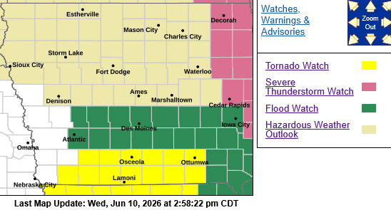
* Tornado Watch for portions of: Southern Iowa effective this Wednesday afternoon and evening from 210 PM until 900 PM CDT. Area Counties included in the TORNADO WATCH:
- ADAMS
- PAGE
- RINGGOLD
- TAYLOR
- UNION
* Primary threats include…
- A few tornadoes likely with a couple intense tornadoes possible
- Scattered damaging winds and isolated significant gusts to 75 mph likely
- Scattered large hail and isolated very large hail events to 3 inches in diameter likely
SUMMARY…Thunderstorm development is anticipated this afternoon within the warm and very unstable airmass across the region. Deep-layer shear is strong enough for supercells capable of all hazards, including very large hail to 3″ in diameter and tornadoes. A strong tornado (EF2+) is possible. Strong downbursts are anticipated as well, with one or more severe bowing clusters possible as the mode trends more linear with time.
PRECAUTIONARY/PREPAREDNESS ACTIONS…
REMEMBER…A Tornado Watch means conditions are favorable for tornadoes and severe thunderstorms in and close to the watch area. Persons in these areas should be on the lookout for threatening weather conditions and listen for later statements and possible warnings.