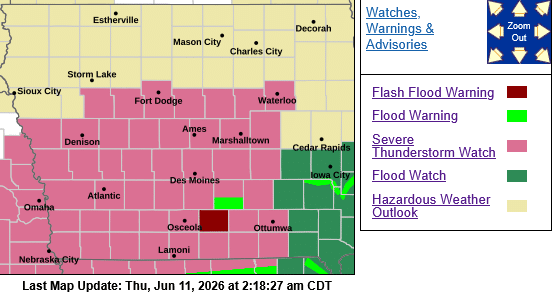
Severe Thunderstorm Watch Number 310
   NWS Storm Prediction Center Norman OK
   210 AM CDT Thu Jun 11 2026

   The NWS Storm Prediction Center has issued a

   * Severe Thunderstorm Watch for portions of
     Western and Central Iowa
     Northern Missouri
     South-Central and Eastern Nebraska

   * Effective this Thursday morning from 210 AM until 1000 AM CDT.

   * Primary threats include...
     Scattered large hail likely with isolated very large hail events
       to 3 inches in diameter possible
     Isolated damaging wind gusts to 70 mph possible
     A tornado or two possible

SUMMARY...Mostly elevated strong to severe thunderstorms will continue to develop overnight, initially across south-central/eastern Nebraska, while eventually expanding into western/central Iowa and far northern Missouri. This will include the Interstate 80 corridor. Large hail is expected to be the most common hazard, but surface-based storm potential could increase mainly toward/after sunrise including what could be an increasing damaging wind risk.

PRECAUTIONARY/PREPAREDNESS ACTIONS...

REMEMBER...A Severe Thunderstorm Watch means conditions are favorable for severe thunderstorms in and close to the watch area. Persons in these areas should be on the lookout for threatening weather conditions and listen for later statements and possible warnings. Severe thunderstorms can and occasionally do produce  tornadoes.

A FLOOD WATCH ALSO REMAINS IN EFFECT FROM 4 AM TO 11 AM CDT THIS MORNING.