(Valley, NE) – The National Weather Service Office in Omaha/Valley, NE, Friday afternoon, confirmed four tornadoes touched down in parts of Harrison, Fremont and Page Counties.
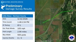
The first happened at around 1:46-p.m. one-point-five (1.5) miles north/northwest of Little Sioux, in Harrison County just southeast of the intersection of 120th Street and Dayton Avenue. It continued northeast, flipping-over a center-pivot irrigation system. As it continued northeast, the twister damaged farm outbuildings, tree and power poles near 120th & Early Avenue. Just over a mile from that intersection, another center-pivot system was overturned before the tornado turned slightly more eastward and tore the fabric roofing off of a hoop barn near Gage Lane and Easton Trail, where the tornado dissipated. Officials rated the tornado as an EF-1 on the Fujita Scale, packing peak estimated winds of 105-mph. It lasted for 2.9-miles and was an estimated 500-yards wide.
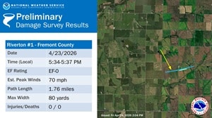
A second, weak tornado seen on several videos and photographs from multiple angles, indicated the twister (Rated an EF-O with top winds of up to 70-mph) began at around 5:34-p.m. five-miles southeast of Riverton, in Fremont County. When it touched down it traveled to the east-northeast for about a mile and three-quarters. The Weather Service says while the near surface dust cloud was wider (About 80-yards), the actual core circulation was quite narrow and weak. The only damage along its track was minor tree damage, as the tornado crossed mostly open fields. The twister ended at around 5:37-p.m, about five-miles south of Farragut.
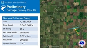
The third tornado was classified as “small,” and an EF-U (Unknown strength). It was confirmed through video and photographic evidence and estimated to be 20-yard wide at the most. The event began at around 5:34-p.m. five-miles south of Riverton and ended about two-minutes later after being on the ground for a little more than one-half mile.
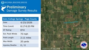
The fourth tornado Thursday, three-miles east of Coin, in Page County, was confirmed through Storm Spotter reports, with a funnel rotating dust at the ground level, with minor tree damage at one location. The track (about 2.1-miles, at a width of 20-yards), was mainly over open fields. It began at around 6:17-p.m. and ended three-minutes later two-miles north/northwest of College Springs.
No injuries were associated with any of the events. The Weather Service says the information is preliminary and subject to change pending final review of the events and publication in NWS Storm Data.
For reference, the Enhanced Fujita Scales classifies tornadoes into the following categories:
- EF-0…..65 to 85 mph winds
- EF-1…..86 to 110 mph winds
- EF-2…..111-135 mph winds
- EF-3…..136-165 mph winds
- EF-4…..166-200 mph winds
- Ef-5…..Wind greater than 200 mph.