
(Des Moines, IA) – The National Weather Service has confirmed six tornadoes in Iowa from the severe weather that impacted the state on Thursday, June 11. Officials say an early morning round of severe weather occurred as a line of storms trekked across the state. It brought damaging winds in excess of 70-mph, a few tornadoes, and large hail. Damaging winds continued behind the storms due to the formation of a wake low.
Five tornadoes occurred during the early morning hours as a line of thunderstorms raced from west to east across the state, primarily along and south of Interstate 80. An additional tornado was confirmed later that afternoon near Ainsworth in southeast Iowa.
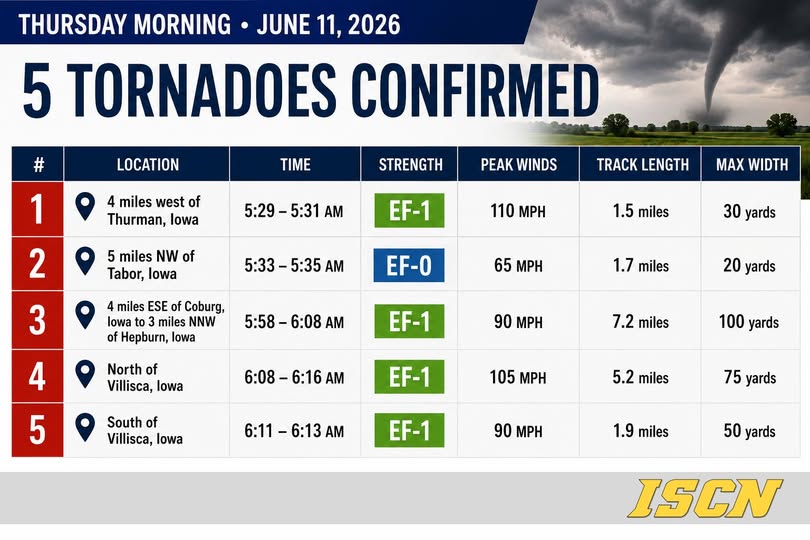
Of the six confirmed tornadoes, three were rated EF-1, two were rated EF-0, and one remains unrated because it did not impact any structures, trees, or other damage indicators that could be used to determine its intensity.
Confirmed tornadoes include:
![]() Near Thurman — EF-1, 110 mph winds
Near Thurman — EF-1, 110 mph winds
![]() Near Tabor — EF-0, 65 mph winds
Near Tabor — EF-0, 65 mph winds
![]() Near Coburg to Hepburn — EF-1, 90 mph winds
Near Coburg to Hepburn — EF-1, 90 mph winds
![]() North of Villisca — EF-1, 105 mph winds
North of Villisca — EF-1, 105 mph winds
![]() South of Villisca — EF-1, 90 mph winds
South of Villisca — EF-1, 90 mph winds
![]() Near Ainsworth — EF-Unknown
Near Ainsworth — EF-Unknown
The strongest tornado reached peak winds of 110 mph near Thurman, while the longest track stretched 7.2 miles from near Coburg to near Hepburn.
The Ainsworth tornado was observed around 4:05 PM. Because it remained over open country and did not strike any damage indicators, the National Weather Service was unable to assign an EF rating or estimate its wind speed


