
**FROST ADVISORIES ARE IN EFFECT THIS MORNING**
Today: Patchy frost before 8am. Otherwise, sunny, with a high near 59. North northwest wind 5 to 9 mph.
Tonight :Mostly clear, with a low around 36. North northwest wind 5 to 8 mph becoming light and variable in the evening.
Saturday: Sunny, with a high near 65. Light and variable wind becoming south southwest 5 to 8 mph in the morning.
Saturday Night: Partly cloudy, with a low around 44. South wind 5 to 7 mph.
Sunday: Mostly sunny, with a high near 71. Breezy, with a south wind 7 to 12 mph increasing to 13 to 18 mph in the afternoon. Winds could gust as high as 25 mph.
Sunday Night: A 20 percent chance of showers and thunderstorms. Partly cloudy, with a low around 53.
Monday: A 50 percent chance of showers and thunderstorms. Mostly cloudy, with a high near 72. Breezy.
349 AM CDT FRI MAY 16 2014
FROST ADVISORY REMAINS IN EFFECT UNTIL 7 AM FOR THE FOLLOWING AREA COUNTIES: SAC-CRAWFORD-CARROLL- AUDUBON-GUTHRIE-DALLAS-CASS-ADAIR-MADISON-ADAMS-UNION-TAYLOR AND RINGGOLD.
AND A FROST ADVISORY REMAINS IN EFFECT UNTIL 8AM FOR: HARRISON-SHELBY-POTTAWATTAMIE-MILLS-MONTGOMERY-FREMONT-PAGE COUNTIES.
* TEMPERATURE…LOWS OF 30 TO 35 DEGREES ARE EXPECTED.
* IMPACTS…SENSITIVE OUTDOOR VEGETATION COULD BE DAMAGED OR KILLED IF LEFT UNPROTECTED…ESPECIALLY IN SHELTERED OR LOW LYING AREAS.
PRECAUTIONARY/PREPAREDNESS ACTIONS…
A FROST ADVISORY MEANS THAT FROST IS POSSIBLE. SENSITIVE OUTDOOR PLANTS MAY BE KILLED IF LEFT UNCOVERED.
345 PM CDT THU MAY 15 2014
…NEAR FREEZING TEMPERATURES EXPECTED TONIGHT…
A WEAK AREA OF HIGH PRESSURE WILL PUSH INTO WESTERN IOWA TONIGHT. MOSTLY CLEAR SKIES AND LIGHT WINDS WILL ALLOW FOR TEMPERATURES TO FALL TO NEAR FREEZING IN THE EARLY MORNING HOURS. FROST WILL BE POSSIBLE.
COUNTIES: SAC-CRAWFORD-CARROLL-AUDUBON-GUTHRIE-DALLAS-CASS-ADAIR-MADISON-ADAMS-UNION-TAYLOR-RINGGOLD.
…FROST ADVISORY IN EFFECT FROM 4 AM TO 7 AM CDT FRIDAY…
THE NATIONAL WEATHER SERVICE IN DES MOINES HAS ISSUED A FROST ADVISORY…WHICH IS IN EFFECT FROM 4 AM TO 7 AM CDT FRIDAY.
* TIMING…TEMPERATURES WILL FALL THROUGHOUT THE OVERNIGHT HOURS…WITH THE COLDEST TEMPERATURES OCCURRING IN THE EARLY MORNING HOURS NEAR SUNRISE.
* TEMPERATURE…LOWS FROM NEAR FREEZING TO THE UPPER 30S ARE EXPECTED.
* IMPACTS…SENSITIVE OUTDOOR VEGETATION COULD BE DAMAGED OR KILLED IF LEFT UNPROTECTED…ESPECIALLY IN SHELTERED OR LOW LYING AREAS.
PRECAUTIONARY/PREPAREDNESS ACTIONS…
A FROST ADVISORY MEANS THAT FROST IS POSSIBLE. SENSITIVE OUTDOOR PLANTS MAY BE KILLED IF LEFT UNCOVERED.
DES MOINES, Iowa (AP) – Recent heavy rainfall has washed away or at least lessened drought conditions in swaths of Nebraska and Iowa. A report released Thursday by the National Drought Mitigation Center at the University of Nebraska-Lincoln says drenching rains led to significant improvements for areas of the two states considered to be in drought. Brian Fuchs, a climatologist at the center, says overall drought reduced last week by nearly 12 percent in Iowa and about 17 percent in Nebraska.
The report says western Iowa saw the greatest improvement in the state. Nebraska saw a substantial reduction in the east-central region, with a pocket now considered drought-free. Fuchs says the improvements seen within the past week are noteworthy, as changes in drought status typically occur slowly.
346 AM CDT THU MAY 15 2014
EARLY THIS MORNING…PARTLY CLOUDY. NORTH WIND 10 TO 15 MPH WITH GUSTS TO AROUND 35 MPH.
TODAY…SUNNY IN THE MORNING…THEN PARTLY SUNNY WITH ISOLATED LIGHT SHOWERS IN THE AFTERNOON. BREEZY…COOLER. HIGH IN THE MID 50S. NORTHWEST WIND 10 TO 20 MPH. CHANCE OF SHOWERS 20 PERCENT.
TONIGHT…MOSTLY CLOUDY WITH ISOLATED LIGHT RAIN SHOWERS IN THE EVENING…THEN PARTLY CLOUDY OVERNIGHT. PATCHY FROST EARLY IN THE MORNING. LOW IN THE MID 30S. NORTHWEST WIND NEAR 10 MPH. GUSTS UP TO 20 MPH THROUGH MIDNIGHT. CHANCE OF SHOWERS 20 PERCENT.
FRIDAY…MOSTLY SUNNY. PATCHY FROST THROUGH MID MORNING. A 20 PERCENT CHANCE OF LIGHT RAIN SHOWERS IN THE AFTERNOON. HIGH AROUND 60. NORTHWEST WIND NEAR 10 MPH.
FRIDAY NIGHT…PARTLY CLOUDY. LOW IN THE UPPER 30S. NORTH WIND 5 TO 10 MPH SHIFTING TO THE SOUTH AFTER MIDNIGHT.
SATURDAY…MOSTLY SUNNY. HIGH IN THE MID 60S. SOUTHWEST WIND 5 TO 10 MPH.
SATURDAY NIGHT AND SUNDAY…PARTLY CLOUDY. LOW IN THE UPPER 40S. HIGH 65 TO 70.
The Freese-Notis weather forecast for the KJAN listening area and weather information for Atlantic.
Podcast: Play in new window | Download (988.8KB)
Subscribe: RSS
The Freese-Notis weather forecast and weather information for Atlantic.
Podcast: Play in new window | Download (998.0KB)
Subscribe: RSS
The National Weather Service said late Monday evening, there were not one, but two tornadoes that occurred between Guthrie Center and Panora, Sunday night. Officials say the strongest of the tornadoes formed south of Guthrie Center and quickly tracked northeast across Lake Panorama, where it briefly produced EF-2 damage.
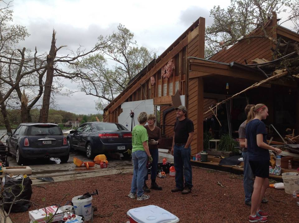
A second tornado formed on the north end of Lake Panorama, and damaged a number of homes along the shore, before dissipating. A third tornado formed south of Dallas Center and tracked across farmland, damaging several out buildings. There were no injuries reported.
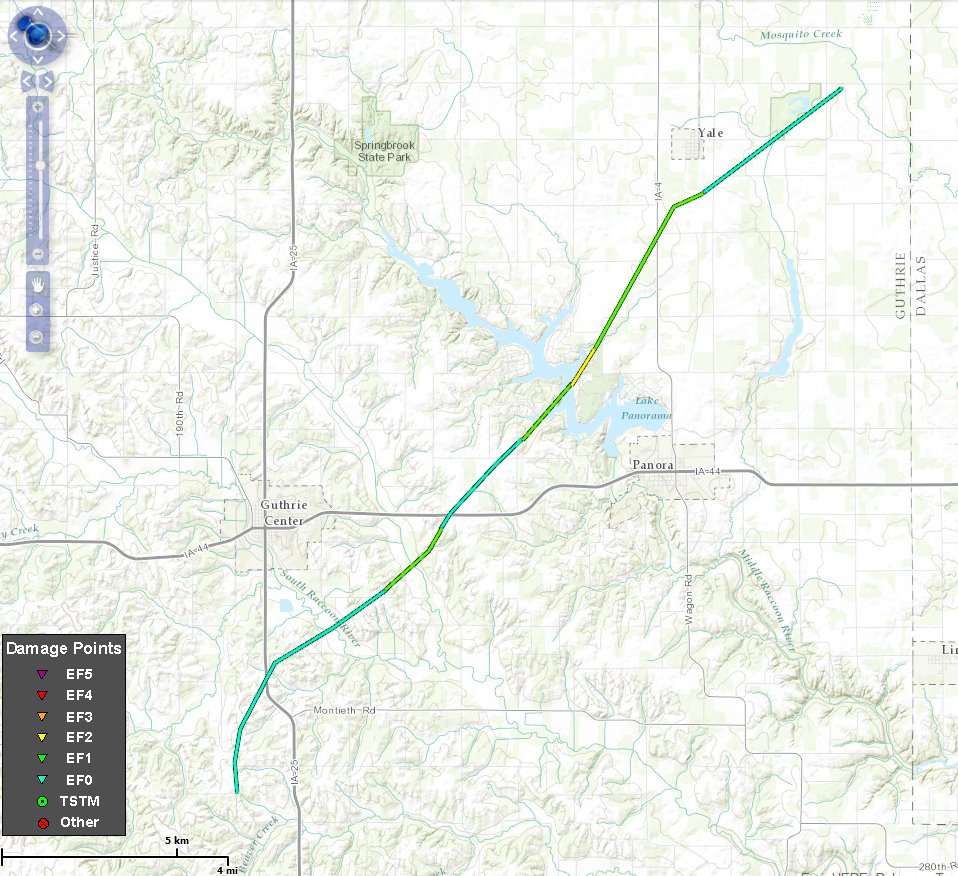
Track of the 1st tornado (NWS graphic)
The first tornado formed at around 9:43-p.m. Sunday, 4.5-miles south of Guthrie Center and tracked northeast for nearly 17 miles. The 100-yard wide twister strengthened as it reached Lake Panorama, packing winds of up to 115-miles per hour. It went across Lake Panorama and damaged a number of homes and trees before dissipating 3-miles northeast of Yale.
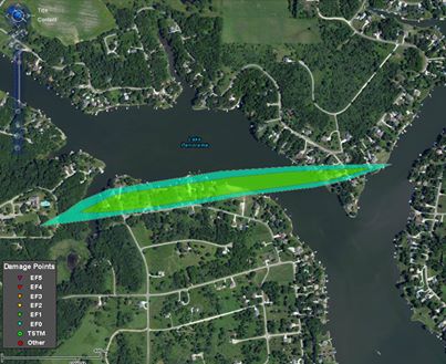
Tornado 2 track
The second, weaker tornado formed just before 10-p.m. Sunday, about 4-miles northwest of Panora and ended a little more a little than 3-miles northwest of town, or a distance of about nine-tenths of a mile. It was about 120-yards wide and had a peak wind speed of 100-miles per hour. It caused extensive tree, roof and dock damage.
Lake Panorama area damage
The third twister happened at around 10:20-p.m. 3.5-miles north-northwest of Dallas Center and ended 6-miles later, 4-miles northwest of Granger. It was 100-yards wide and packed winds of up to 85 miles per hour. The tornado caused damage primarily to farm outbuildings in the rural areas.
346 AM CDT TUE MAY 13 2014
EARLY THIS MORNING…MOSTLY CLOUDY. COLDER. NORTHWEST WIND AROUND 15 MPH WITH GUSTS TO AROUND 25 MPH.
TODAY…PARTLY SUNNY. BREEZY. HIGH IN THE LOWER 60S. NORTHWEST WIND 15 TO 20 MPH WITH GUSTS TO AROUND 30 MPH.
TONIGHT…PARTLY CLOUDY. LOW IN THE UPPER 30S. NORTHWEST WIND 5 TO 10 MPH. GUSTS UP TO 25 MPH THROUGH MIDNIGHT.
WEDNESDAY…MOSTLY SUNNY. A SLIGHT CHANCE OF SHOWERS EARLY IN THE AFTERNOON. A CHANCE OF LIGHT SHOWERS LATE IN THE AFTERNOON. HIGH IN THE MID 60S. NORTH WIND 5 TO 10 MPH. CHANCE OF SHOWERS 30 PERCENT.
WEDNESDAY NIGHT…PARTLY CLOUDY. A 20 PERCENT CHANCE OF SHOWERS THROUGH MIDNIGHT. LOW AROUND 40. NORTH WIND 5 TO 10 MPH.
THURSDAY…PARTLY SUNNY WITH A CHANCE OF LIGHT SHOWERS AND ISOLATED THUNDERSTORMS. HIGH IN THE UPPER 50S. NORTH WIND 5 TO 15 MPH. CHANCE OF PRECIPITATION 30 PERCENT.
FRIDAY…MOSTLY SUNNY WITH A 20 PERCENT CHANCE OF SHOWERS. HIGH IN THE UPPER 50S.
PANORA, Iowa (AP) — Preliminary data shows an EF-2 tornado touched down in central Iowa during severe weather that hit swaths of the state. The National Weather Service says a line of thunderstorms produced at least one tornado Sunday night that hit the community surrounding Lake Panorama in Panora. Officials are still surveying damage to determine if other tornadoes were recorded.
The tornado reached 115 mph and was first recorded south of Guthrie Center before it traveled more than 16 miles northeast. It went across Lake Panorama and dissipated near Yale. Officials in Lake Panorama say the tornado destroyed eight condominiums and damaged about a dozen other homes. No injuries were reported.
More severe weather was expected in Iowa later Monday, with thunderstorms and potential flash flooding.


