


Drought Monitor still shows Abnormally dry soil conditions
September 10th, 2021 by Ric Hanson
The latest U.S. Drought Monitor (USDM) data released Thursday, indicates this past week saw continued improvement in conditions across drought-stricken areas of the Central and Northern Plains states as well as in Iowa and Minnesota, where light-to-moderate rainfall accumulations were observed. On this week’s map, widespread one-category improvements were made in drought-stricken areas in northern Iowa and western Minnesota, which received another round of beneficial precipitation this week. In those areas rainfall accumulations ranged from 1 to 4 inches. In areas of northern Iowa and southern Minnesota, percentage of normal precipitation has ranged from 150% to 300% of normal for the last 30-day period.
Likewise, light rainfall this week led to trimming back of small areas of Moderate Drought (D1) in northwestern Illinois and west-central Indiana. Conversely, dry conditions during the past 90-day period led to slight expansion of areas of Severe Drought (D2) in northern Wisconsin as well as areas of Moderate Drought (D1) in Upper Peninsula Michigan.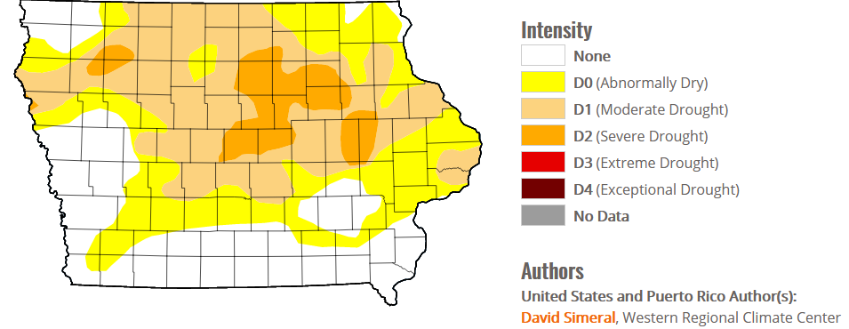
In the immediate KJAN listening area, the Drought Monitor map shows Abnormally dry conditions remain over most of Cass, Adair, Audubon, Montgomery and Madison Counties, along with small sections of Mills, Adams, Fremont and Page Counties. Under those conditions, corn shows drought stress and the soil is dry The southeast quarter of Guthrie and most of Dallas County, is in a Moderate Drought. In a moderate drought: Soybeans abort pods; corn test weights are struggling; Grasses are brown; more grass fires occur; burn bans are issued, and pond levels decline.
The NWS Precipitation Forecast calls light precipitation accumulations (generally under 1 inch) during the week ahead.
