Sky-Scan Forecast for Atlantic & Area 9/7/2026
Labor Day: A 50 percent chance of showers and thunderstorms, mainly before 10am. Some of the storms could produce heavy rainfall. Partly sunny, with a


Labor Day: A 50 percent chance of showers and thunderstorms, mainly before 10am. Some of the storms could produce heavy rainfall. Partly sunny, with a
Today: Sunny, with a high near 94. Heat index values as high as 103. Calm wind becoming east around 6 mph in the afternoon. Tonight:

Today: Mostly sunny, with a high near 94. Heat index values as high as 103. South southwest wind 8 to 11 mph, with gusts as
Iowa’s in the midst of what may be the year’s final heat wave of 90-plus-degree days, so it could be refreshing for some of us
Today: A chance of showers and thunderstorms before 10am, then a slight chance of showers between 10am and noon. Partly sunny, then gradually becoming sunny,
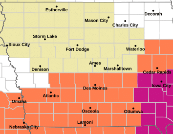
URGENT – WEATHER MESSAGENational Weather Service Des Moines IA405 AM CDT Wed Sep 2 2026Audubon-Guthrie-Cass-Adair-Adams-Taylor-Including the cities of Bayard, Corning, New Market, Adair, Exira,Bedford, Lenox,
Today: A slight chance of showers and thunderstorms between 7am and noon. Mostly sunny, with a high near 93. Heat index values as high as
Today: Mostly sunny, with a high near 93. Heat index values as high as 100. Calm wind becoming south 5 to 7 mph in the
Today: A slight chance of showers and thunderstorms between 8am and noon. Mostly sunny, with a high near 92. West wind 5 to 7 mph.
Today: Patchy fog before 8am. Otherwise, mostly sunny, with a high near 84. Calm wind becoming south southwest 5 to 8 mph in the morning.
Today: Sunny, with a high near 84. Calm wind becoming northwest around 5 mph in the afternoon. Tonight: Mostly clear, with a low around 60.
Today: Patchy fog before 7am. Otherwise, sunny, with a high near 82. Light northwest wind becoming north northwest 6 to 11 mph in the morning.