
Nebraska and Iowa are among those states preparing for another blast of wintry weather this weekend. The National Weather Service has issued a winter weather advisory for much of eastern Nebraska and most of Iowa beginning Saturday evening through Sunday morning. The weather service says the region could see light snow accumulations of 1 to 2 inches in northern areas and up to 4 inches further south.
But the weather service says high winds and plummeting temperatures will make for dangerous conditions for travelers and anyone venturing outdoors. Temperatures are expected to drop to near zero by midnight and into Sunday morning, and wind chills could fall to 20-below zero.
WINTER WEATHER ADVISORY REMAINS IN EFFECT FROM 6 PM THIS EVENING TO 6 AM CST SUNDAY for SAC-CRAWFORD-CARROLL-AUDUBON-GUTHRIE-DALLAS-CASS-ADAIR-MADISON-ADAMS-UNION-TAYLOR and RINGGOLD COUNTIES, and FROM 6PM THIS EVENING UNTIL 10-A.M. SUNDAY for MONONA-FREMONT-HARRISON-SHELBY-PAGE POTTAWATTAMIE-MILLS and MONTGOMERY COUNTIES.
* TIMING…THIS EVENING INTO LATE TONIGHT.
* STORM TOTAL SNOW/ICE ACCUMULATIONS…1 TO 2 INCHES WITH SOME HIGHER AMOUNTS POSSIBLE.
* WINDS/VISIBILITY…NORTHWEST WINDS WILL INCREASE TO 20 TO 30 MPH WITH SOME HIGHER GUSTS TO 40 MPH OVERNIGHT TONIGHT. VISIBILITIES MAY REDUCED TO ONE HALF MILE OR LESS AT TIMES IN THE SNOW AND BLOWING SNOW OVERNIGHT.
* IMPACTS…HAZARDOUS TRAVEL CONDITIONS ARE POSSIBLE DUE TO THE POTENTIAL FOR MIXED PRECIPITATION…SNOW AND BLOWING SNOW AS ICY CONDITIONS ARE EXPECTED TO DEVELOP TONIGHT. BITTERLY COLD WIND CHILLS ARE ALSO EXPECTED LATE TONIGHT.
PRECAUTIONARY/PREPAREDNESS ACTIONS…
A WINTER WEATHER ADVISORY MEANS THAT PERIODS OF SNOW…OR FREEZING RAIN WILL CAUSE TRAVEL DIFFICULTIES. BE PREPARED FOR SLIPPERY ROADS AND LIMITED VISIBILITIES…AND USE CAUTION WHILE DRIVING.
A WINTER WEATHER ADVISORY FOR BLOWING SNOW MEANS THAT VISIBILITIES WILL BE LIMITED DUE TO STRONG WINDS BLOWING SNOW AROUND. USE CAUTION WHEN TRAVELING…ESPECIALLY IN OPEN AREAS.
Several weather systems will move through Iowa the next three days. The first, and widely advertised snowfall will begin late this afternoon in northwest Iowa and move southeast throughout the state as the night goes on. All of Iowa could see freezing drizzle before the snow arrives tonight, but little to no ice accumulation is expected. Once the snow starts it should be light with amounts of 1-2 inches common across most of the state.
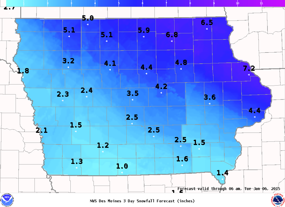
Expected snowfall totals thru 6-a.m. Tue., 1/6/15
Icy spots will develop on area roadways. Motorists are advised to anticipate the slipper conditions and to please drive with care. As the snow ends, strong winds of 20-30 miles an hour will cause dangerous wind chills and blowing snow conditions overnight and on Sunday. By Monday, a second clipper storm system will also move through north central and northeast Iowa dropping even more snow.
(Iowa Storm Chasing Network)
Today: Mostly Cloudy w/a 30% chance of snow and freezing drizzle after 5pm. High near 32. Light and variable wind becoming north northwest 5 to 10. Little or no snow accumulation expected.
Tonight: An 80% chance of snow and freezing rain before 4am, then a slight chance of snow between 4am and 5am. Low around 1. N/NW winds at 15-30 mph w/gust to near 40. Little or no ice accumulation expected. New snow accumulation of around an inch possible.
Sunday: Mostly sunny, windy & cold, with a high near 5. NW winds at 15-30 mph decreasing during the after noon to around 10-15mph.
Sunday Night: Mostly cloudy, with a low around -5. NW winds 5-10mph. Wind chill values as low as -20.
Monday: Partly sunny & breezy, with a high near 13. W/SW winds 15-25mph. B
Monday Night: Mostly Cloudy w/patchy blowing snow and a slight chance of snow. Low around 7. Windy. Chance of precipitation is 20%.
Tuesday: Partly sunny & windy, with a high near 16.
351 AM CST SAT JAN 3 2015
THE NATIONAL WEATHER SERVICE IN DES MOINES HAS ISSUED A WINTER WEATHER ADVISORY FOR SNOW AND BLOWING SNOW…WHICH IS IN EFFECT FROM 6 PM THIS EVENING TO 6 AM CST SUNDAY FOR: SAC-CRAWFORD-CARROLL-GREENE-AUDUBON-GUTHRIE-DALLAS-CASS-ADAIR-MADISON-ADAMS-UNION-TAYLOR-RINGGOLD COUNTIES.
MONONA-HARRISON-SHELBY-POTTAWATTAMIE-MILLS: WINTER WEATHER ADVISORY REMAINS IN EFFECT FROM 6 PM THIS EVENING TO 10 AM CST SUNDAY...
* TIMING…THIS EVENING INTO LATE TONIGHT.
* STORM TOTAL SNOW/ICE ACCUMULATIONS…1 TO 2 INCHES WITH SOME HIGHER AMOUNTS POSSIBLE.
* WINDS/VISIBILITY…NORTHWEST WINDS WILL INCREASE TO 20 TO 30 MPH WITH SOME HIGHER GUSTS TO 40 MPH OVERNIGHT TONIGHT. VISIBILITIES MAY REDUCED TO ONE HALF MILE OR LESS AT TIMES IN THE SNOW AND BLOWING SNOW OVERNIGHT.
* IMPACTS…HAZARDOUS TRAVEL CONDITIONS ARE POSSIBLE DUE TO THE POTENTIAL FOR MIXED PRECIPITATION…SNOW AND BLOWING SNOW AS ICY CONDITIONS ARE EXPECTED TO DEVELOP TONIGHT. BITTERLY COLD WIND CHILLS ARE ALSO EXPECTED LATE TONIGHT.
PRECAUTIONARY/PREPAREDNESS ACTIONS…
A WINTER WEATHER ADVISORY MEANS THAT PERIODS OF SNOW…OR FREEZING RAIN WILL CAUSE TRAVEL DIFFICULTIES. BE PREPARED FOR SLIPPERY ROADS AND LIMITED VISIBILITIES…AND USE CAUTION WHILE DRIVING.
A WINTER WEATHER ADVISORY FOR BLOWING SNOW MEANS THAT VISIBILITIES WILL BE LIMITED DUE TO STRONG WINDS BLOWING SNOW AROUND. USE CAUTION WHEN TRAVELING…ESPECIALLY IN OPEN AREAS.
The Freese-Notis forecast for the KJAN listening area and weather information for Atlantic.

Podcast: Play in new window | Download (708.7KB)
Subscribe: RSS
The National Weather Service in Des Moines reports significant travel concerns are expected Saturday evening into Sunday morning over much of central Iowa. A two part system, with the first looking to pass over Missouri overnight tonight into Saturday will provide the potential for a wintry mix over south-central to southeast Iowa Saturday morning. The second and stronger piece of energy will bring the main snow band across central Iowa late Saturday afternoon and into Saturday evening.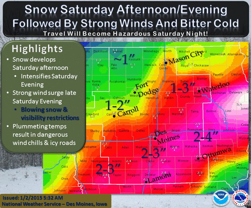
With the sharp cold front Saturday evening, strong northwest winds combined with falling snow will likely lead to areas of blowing snow and visibility restrictions late Saturday evening into Sunday morning. Temperatures are forecast to quickly plummet with the strong push of cold air Saturday night and may result in roads becoming icy and causing significant travel concerns. Generally 1 to 4 inches of snow is forecast over central Iowa by late Saturday night with the higher amounts along and south of Interstate 80 and east of Interstate 35.
Again, the snow amounts are not the major concern, it is the falling snow coupled with the very strong winds Saturday night into Sunday morning. Bitter cold temperatures and wind chills are expected all day Sunday into Sunday night and the cold will persist through much of the work week. Another clipper system looks to bring accumulating light snow to northern Iowa Monday night into Tuesday.
400 AM CST FRI JAN 2 2015
EARLY THIS MORNING…PARTLY CLOUDY. NORTH WIND NEAR 5 MPH.
TODAY…MOSTLY SUNNY. HIGH IN THE LOWER 30S. EAST WIND NEAR 5 MPH SHIFTING TO THE SOUTH AROUND 5 MPH IN THE AFTERNOON.
TONIGHT…PARTLY CLOUDY THROUGH MIDNIGHT THEN BECOMING MOSTLY CLOUDY. LOW IN THE LOWER 20S. SOUTH WIND 5 TO 10 MPH.
SATURDAY...MOSTLY CLOUDY. A SLIGHT CHANCE OF FREEZING DRIZZLE AND LIGHT SNOW IN THE MORNING. A CHANCE OF FREEZING DRIZZLE EARLY IN THE AFTERNOON. A CHANCE OF LIGHT SNOW IN THE AFTERNOON. HIGH IN THE LOWER 30S. SOUTHEAST WIND 5 TO 10 MPH SHIFTING TO THE NORTHWEST WITH GUSTS TO AROUND 20 MPH IN THE AFTERNOON. CHANCE OF PRECIPITATION 50 PERCENT.
SATURDAY NIGHT…CLOUDY. SNOW LIKELY THROUGH MIDNIGHT…THEN A CHANCE OF SNOW AFTER MIDNIGHT. AREAS OF BLOWING SNOW AFTER MIDNIGHT. WINDY. MUCH COLDER. LIGHT SNOW ACCUMULATIONS POSSIBLE. LOW ZERO TO 5 ABOVE. NORTH WIND 15 TO 25 MPH SHIFTING TO THE NORTHWEST 25 TO 30 MPH AFTER MIDNIGHT. GUSTS UP TO 40 MPH. CHANCE OF SNOW 70 PERCENT. LOWEST WIND CHILL READINGS 15 TO 20 BELOW AFTER MIDNIGHT.
SUNDAY…MOSTLY SUNNY. BREEZY. MUCH COLDER. HIGH 5 TO 10 ABOVE. NORTHWEST WIND 15 TO 25 MPH DECREASING TO 10 TO 15 MPH IN THE AFTERNOON. WIND CHILL READINGS 15 TO 20 BELOW.
SUNDAY NIGHT…MOSTLY CLOUDY. LOW 5 TO 10 BELOW.
MONDAY…MOSTLY CLOUDY. HIGH 10 TO 15.
Several locations in Iowa recorded low temperatures in the double-digits below-zero over the final two days of 2014 — which will enter the record books as one of the coldest years in the state’s history. State Climatologist Harry Hillaker says only three of the 12 months posted an above normal average temperature (May, June, and December). “And we had three top 10 months as far as low temperatures — the 7th coldest February on record, 5th coolest July and 4th coolest November,” Hillaker said. “Those are all based on 142 years of records, so rather unusual in all those cases.”
The statewide average temperature for the entire year was 45.4 degrees. “The year as a whole…almost the coolest in nearly 100 years. You have to back to 1917 to find a cooler calendar year than 2014,” Hillaker said. The coldest official temperature recorded in Iowa this year was 29-below zero in Elkader — both on January 28 and February 11. “On the other extreme, the warmest reading we had was only 97 degrees on May 7, very early in the season,” Hillaker said. “Clarinda, Shenandoah and Sidney all hit 97 on May 7.”
Not a single Iowa city recorded a temperature in the triple digits through all of 2014. “Statewide, I think we’ve had about a dozen years when no place in the state reached 100 degrees during the course of the year. So, that’s somewhat unusual, but not unheard of by any means,” Hillaker said.
Two-thousand-fourteen will go down as the 15th wettest year in Iowa history. The month of June was especially wet — with record flooding across northwest Iowa. “Some part of the state had a lot of rain during the late summer, especially west-central and southwest Iowa,” Hillaker said. “We had a very wet August. Greenfield has almost a foot-and-a-half of rain just during the month of August.”
Although the year was a wet one, there weren’t many large snow events. “I think the largest snow storm total was 9 inches, which is kind of small for a statewide extreme,” Hillaker said. According to the National Weather Service, there were 55 tornadoes in Iowa in 2014 — slightly more than the 46 twisters that Iowa sees in a typical tornado season (averaged over the years 1980-2013).
For the month of December (2014), the Average High in Atlantic was 36. The Average Low was 22. The normal average High is 33. The normal average Low is 14.We had just 1.06 inches of precipitation last month, with some of that coming from the four-tenths of an inch of snow and/or mixed precip. Normal precipitation for the month is 1.11 inches.


