
Today: Increasing clouds, with a high near 39. Northeast wind 8 to 13 mph becoming east southeast in the afternoon.
Tonight: A slight chance of rain or freezing rain between 3am and 4am, then a chance of rain. Mostly cloudy, with a low around 31. East southeast wind 10 to 15 mph, with gusts as high as 22 mph. Chance of precipitation is 30%. New precipitation amounts of less than a tenth of an inch possible.
Sunday: Rain. High near 49. Windy, with a south southeast wind 20 to 26 mph, with gusts as high as 38 mph. Chance of precipitation is 100%. New precipitation amounts between a half and three quarters of an inch possible.
Sunday Night: Showers, with thunderstorms also possible after 1am. Low around 41. Windy, with a south southeast wind 22 to 26 mph, with gusts as high as 40 mph. Chance of precipitation is 100%. New rainfall amounts between a tenth and quarter of an inch, except higher amounts possible in thunderstorms.
Monday: Showers likely and possibly a thunderstorm. Partly sunny, with a high near 57. Windy, with a south southeast wind around 23 mph, with gusts as high as 34 mph. Chance of precipitation is 70%. New rainfall amounts of less than a tenth of an inch, except higher amounts possible in thunderstorms.
Monday Night: A chance of rain and snow showers before 10pm, then a chance of snow showers. Mostly cloudy, with a low around 22. Windy. Chance of precipitation is 40%. New precipitation amounts of less than a tenth of an inch possible.
Tuesday: A 20 percent chance of snow showers before 1pm. Mostly cloudy, with a high near 34. Windy.
Friday’s High in Atlantic was 38. We received a Trace of rain. Our Low this morning, 21. Last year on this date, the High in Atlantic was 41 and the Low was 21. The all-time Record High in Atlantic on March 23rd, was 86 in 1910. The Record Low was 4 in 1974. Sunrise today: 7:19. Sunset tonight: 7:36.
Today: Rain showers, possibly mixing with snow after 9am, then gradually ending. Some thunder is also possible. High near 40. N winds 10-25 mph. Little or no snow accumulation expected.
Tonight: Partly cloudy & blustery. Low around 24. N/NE @ 10-20 mph.
Saturday: Increasing clouds, with a high near 41. NE winds becoming-E/SE @ 10-15 mph.
Sat. Night: Snow showers likely after 1am, mixing with rain after 4am. Low around 30. New snow accumulation of less than a half inch possible.
Sunday: Rain, possibly mixed with snow showers, becoming all rain after 1pm. High near 49. New precipitation amounts between a half and three quarters of an inch possible.
Sunday Night: Showers, with thunderstorms also possible after 1am. Low around 38.
Monday: Showers likely and possibly a thunderstorm. Mostly cloudy, with a high near 56.
Thursday’s High in Atlantic was 52. The Low was 24. As of 7-a.m. in Atlantic (24-hour precip.), we had received .32″ of rain/sleet at KJAN. Last year on this date, the High in Atlantic was 54 and the Low was 30. The Record High for March 22nd in Atlantic, was 86 in 1910. The Record Low was -6 in 1912. Sunrise: 7:21. Sunset: 7:34-p.m.
Today: Mostly cloudy. Highs in the lower 50s. East winds 10 to 15 mph, becoming southeast this afternoon.
Tonight: Mostly cloudy. A chance of showers with a slight chance of thunderstorms after midnight. Lows in the mid 30s. Southeast winds 10 to 15 mph with gusts up to 25 mph. Chance of rain 50 percent.
Friday: Mostly cloudy with a chance of showers in the morning, then partly sunny in the afternoon. Highs in the mid 40s. North winds 10 to 15 mph, increasing to around 20 mph in the afternoon. Chance of rain 50 percent
Saturday: Mostly sunny in the morning, then mostly cloudy with a chance of rain in the afternoon. Highs in the lower 40s. Northeast winds around 10 mph, becoming southeast in the afternoon. Chance of rain 30 percent.
Saturday Night: Cloudy. A chance of rain and snow after midnight. Breezy with lows in the lower 30s. Chance of precipitation 50 percent.
Sunday: Rain, windy with highs in the upper 40s. Chance of rain 90 percent.
Wednesday’s High in Atlantic was 44. The Low was 24. Last year on this date, the High in Atlantic was 51 and the Low was 38. The Record High for March 21st in Atlantic, was 88 in 1907. The Record Low was -7 in 1960. Sunrise: 7:22. Sunset: 7:33-p.m.
Today: Mostly cloudy through mid morning, then gradual clearing, with a high near 43. Breezy. N @ 10-25 mph.
Tonight: Mostly cloudy, with a low around 25. Northeast wind 5 to 10 mph.
Thursday: Mostly sunny, with a high near 50. Southeast wind 10-25 mph.
Thu. Night: Rain likely and possibly a thunderstorm late. Mostly cloudy, with a low around 35. SE @ 15-25 22 mph.
Friday: Partly sunny w/a30% chance of showers & thunderstorms. High near 49. W/NW winds becoming northerly @ 10-25 mph.
Saturday: P/Sunny w/a 40% chance of snow before 1pm, then a chance of rain. High near 41.
Sat. Night: Rain, possibly mixed with snow, mainly after midnight. Windy. Low around 30.
Sunday: Showers. Windy. High near 50.
Tuesday’s High in Atlantic was 66. The Low was 30. Last year on this date, the High in Atlantic was 60 and the Low was 29. The Record High for March 20th in Atlantic, was 80 in 1938. The Record Low was -7 in 1906. Sunrise: 7:24. Sunset: 7:32-p.m.
Today: Sunny & breezy. High near 62. SW winds @ 10-20 becoming N/NW this afternoon, & gusting to near 25 mph.
Tonight: Increasing clouds, with a low around 26. NW-N/NE @ 10-20 mph.
Wednesday: Partly sunny. High near 42. N/NE @ 10-25 mph.
Thursday: A slight for mixed snow/sleet through mid-day, otherwise Partly sunny. High near 46.
Thu. Night: Breezy w/a slight chance of rain & late thunderstorms. Low around 33.
Friday: Mostly cloudy & breezy w/a chance of rain early. High near 47.
Monday’s High in Atlantic was 39. The Low was 21. Last year on this date, the High in Atlantic was 45 and the Low was 9. The Record High for March 19th in Atlantic, was 79 in 1976. The Record Low was -14 in 1923. Sunrise: 7:26. Sunset: 7:31-p.m.
(Radio Iowa) – Don’t put away those heavy coats, shovels and snow-melt just yet. Tomorrow (Tuesday) marks the first day of spring, but it’s possible a large area of Iowa will be digging out from a winter-weather storm in less than a week. Meteorologist Katie Gross, at the National Weather Service office in Omaha, says they’re following a developing weather system that may arrive over Iowa next Sunday, and could last into the following Tuesday.
“The whole system is still kind of up in the air, with all the models not quite agreeing on what exactly is going to play out just yet,” Gross says. “The best consensus we’ve got so far is that there’s probably going to be some snow falling over parts of northern Iowa, with maybe some heavier rain across the rest of the state.” The computer models are not lining up as to the location of the rain-snow line, but for the moment, it appears the northern few tiers of Iowa counties may see snow late next weekend.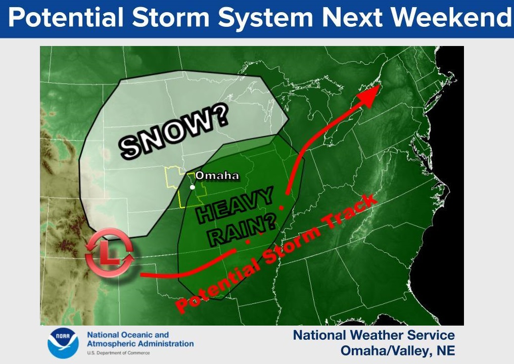
“We are not really certain where exactly this will set up,” Gross says. “If the whole system shifts south, more of Iowa could see snow. If it moves north, more of Iowa will be kind of stuck in that warmer air and get some heavier rain.” She says there is still substantial uncertainty with the storm track, but one thing is sure, Mother Nature often doesn’t pay attention to the calendar.
“This time of year, we’re just kind of in that flux between winter and spring,” Gross says. “It kind of bobs back and forth between the two for a few weeks here.” She suggests you keep a close eye on the forecast throughout the week as the details become more clear.
Today: Sunny & windy, with a high near 41. N/NW winds 15-20 mph. Wind chill values as low as 5.
Tonight: Mostly clear & windy, with a low around 29. SW @ 10-25 mph.
Tuesday: Sunny & breezy, with a high near 61. NW @ 10-25 mph.
Wednesday: Mostly sunny, with a high near 44.
Thursday: Partly sunny w/a 30% chance of rain and snow before 1pm, then a chance of rain. High near 52.
Sunday’s High in Atlantic was 38. The Low was 14. Last year on this date, the High in Atlantic was 26 and the Low was 8. The Record High for March 18th in Atlantic, was 81 in 2012. The Record Low was -1 in 1893. Sunrise: 7:27. Sunset: 7:30-p.m.
Today: Mostly sunny & windy. High near 39. N/NW winds 15-30 mph.
Tonight: Mostly clear & blustery. Low around 16. N/NW winds @10-25 mph. Wind chill values as low as 5.
Monday: Sunny & breezy, with a high near 42. N/NW winds @ 10-20 mph.
Tuesday: Sunny & breezy, with a high near 61. NW @ 10-25 mph.
Wednesday: Mostly sunny, with a high near 45.
Saturday’s High in Atlantic was 53. The Low was 24. Last year on this date, the High in Atlantic was 35 and the Low was 9. The Record High for March 17th in Atlantic, was 84 in 1894. The Record Low was -11 in 1906. Sunrise: 7:29. Sunset: 7:29-p.m.


