
Today: Partly cloudy to cloudy. High 66. S winds @ 10-15 becoming Northerly.
Tonight: Isolated showers this evening; P/Cldy overnight. Low 40. NW @ 5-10.
Tomorrow: P/Cldy. High near 70. W @ 10-15.
Saturday: Mostly sunny. High 65.
Sunday: P/Cldy. High 74.
Wednesday’s High in Atlantic was 67. We received just a Trace of precipitation after 7-a.m. (The 24-hour gauge reset time). Our Low this morning (as of 6:25-a.m.), was 29. Last year on this date, the High in Atlantic was 45 and the Low was 35. The All-Time Record High in Atlantic on this date was 92 in 1987 and 1989. The Record Low was 15 in 1907.
Today: Mostly cloudy w/light rain this morning; Becoming Partly cloudy. High 64. N @ 10-15mph.
Tonight: P/Cldy. Low 36. Light & variable breeze.
Tomorrow: P/Cldy to Cloudy w/a chance of showers, late. High 66. S winds becoming N @ 10-15.
Friday: P/Cldy. High 66.
Saturday: P/Cldy. High 68.
Tuesday’s High in Atlantic was 77. Our Low was 38. We received .06″ rain overnight at the KJAN studios (as of 5-a.m.). Last year on this date our High was 64 and the Low was 38. The record High in Atlantic on this date was 91 in 2010. The Record Low was 20, in 1934.
Today: Increasing cloudiness w/a chance of showers this evening. High 72. NE @ 10.
Tonight: Mostly cloudy w/light rain. Low 48. NE @ 5-10.
Tomorrow: Showers ending early; Becoming Partly cloudy. High 64. NE @ 10-15.
Thursday: Mo. Cldy w/a chance of showers late. High 66.
Friday: P/Cldy. High 64.
Monday’s High in Atlantic was 75. Our Low was 33. Last year on this date our High was 75 and the Low was 51. The record High in Atlantic on this date was 91 in 1989. The Record Low was 9, in 1956.
Officials with the Shelby County Emergency Management Agency report the danger of fire spreading is getting much greater this week. They ask fire stations and participating businesses to place your Fire Danger notification signs into the HIGH category. Authorities say persons planning a controlled burn to “Plan your burn in advance and talk to your local Fire Chief before you start a fire that may be harder to control than anticipated.”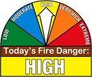
Today: Partly cloudy. High 72. NE @ 10.
Tonight: Fair to P/Cldy. Low 50. Winds light & variable.
Tomorrow: P/Cldy to Cldy w/a chance of afternoon shwrs. High 68. SE @ 10.
Wednesday: Shower possible early, otherwise P/Cldy. High 63.
Thursday: P/Cldy to Cldy w/a chance of afternoon showers. High 68.
Sunday’s High in Atlantic was 70. Our Low this morning (as of 4:55-a.m.) was 34. Last year on this date, the High in Atlantic was 71 and the Low 32. The Record High here, for April 23rd, was 88 in 1950, and the Record Low 19, in 1893.
Today: Partly sunny, with a high near 63. East northeast wind 5 to 10 mph.
Tonight: Partly cloudy, with a low around 39. East northeast wind 5 to 10 mph becoming light northeast.
Monday: Mostly sunny, with a high near 67. Northeast wind 5 to 10 mph.
Monday Night: Partly cloudy, with a low around 43. East northeast wind at around 5mph.
Tuesday: Partly Sunny w/a 20% chance of rain after 1pm. High near 64. N/NE winds becoming N/NW @ 5-10 in the morning.
Tuesday Night: Mostly cloudy w/a 20% chance of rain. Low around 39.
Wednesday: Mostly sunny, with a high near 60.
Wednesday Night: Mostly clear, with a low around 39.
Thursday: Partly sunny & breezy, with a high near 62.
Saturday’s High in Atlantic was 56. Our Low this morning, 44. Last year on this date, the High in Atlantic was 69 and the Low was 31. The Record High for Atlantic on April 22nd, was 90 in 1980. The Record Low was 20, in 1936.
Today: P/Cldy to Cldy. High 60. SE @ 10.
Tonight: Mo. Cldy. Low 40. SE @ 5-10.
Tomorrow: Mo. Cldy w/scattered light rain showers. High 57. E @ 10.
Sunday: P/Cldy. High 63.
Monday: P/Cldy. High 68
Thursday’s High in Atlantic was 58. Our Low was 26. Last year on this date our High was 58 and the Low was 37. The record High in Atlantic on this date was 90 in 1902. The Record Low was 18, in 1956.
DES MOINES, Iowa (AP) — Forecasters say minor flooding is expected following the spring storm that dumped several inches of snow on most of northern Iowa. Up to a foot (30 centimeters) of snow was reported Thursday in Winnebago County after Wednesday’s storm moved through the state. Other spots reported less.
The National Weather Service issued a warning early this (Thursday) morning for the Cedar River at Cedar Falls. The water was nearing flood stage of 88 feet (27 meters) and is forecast to crest 18 inches (46 centimeters) above flood stage Tuesday evening. Flooding in a corner of Tourist Park is likely.
Minor flooding also is expected along the Winnebago River in Mason City, the Rock River at Rock Rapids, the Ocheyedan River near Spencer and the Little Sioux River at Cherokee,
Today: Partly cloudy. High 49. N @ 10.
Tonight: Fair to p/cldy. Low 27. SE @ 5.
Tomorrow: P/Cldy to Cldy. High 55. SE @ 10-15.
Saturday: Mo. Cldy w/scattered light rain. High 55.
Sunday: P/Cldy. High 63.
Wednesday’s High in Atlantic was 41. Our Low this morning (as of 4:45-a.m.) was 25. Last year on this date, the High in Atlantic was 78 and the Low was 48. The Record High in Atlantic on April 19th, was 87 in 1908, 1946 and 1987. The Record Low was 15 in 1988.
Crawford-Carroll-Greene-Audubon-Guthrie Counties…A WINTER WEATHER ADVISORY REMAINS IN EFFECT UNTIL 7 PM TODAY (4/18).
Mixed precipitation can be expected. Additional snow accumulations of 2 to 4 inches and ice accumulations of up to one tenth of an inch are expected. The ice will result in difficult travelconditions, including during the morning commute. Expect
reduced visibilities at times.
A Winter Weather Advisory means that periods of snow, sleet or freezing rain will cause travel difficulties. Expect slippery roads and limited visibilities, and use caution while driving. The latest road conditions for the state you are calling from can be obtained by calling 5 1 1.


