
Severe Thunderstorm Warning
National Weather Service Omaha/Valley Nebraska
346 PM CDT SUN JUN 17 2018

The National Weather Service in Omaha has issued a

* Severe Thunderstorm Warning for...
  Northwestern Pottawattamie County in southwestern Iowa...
  Southwestern Harrison County in southwestern Iowa...
  Eastern Washington County in east central Nebraska...

* Until 415 PM CDT.

* At 345 PM CDT, a severe thunderstorm was located 4 miles west of
  Fort Calhoun, or 15 miles north of Omaha, moving northeast at 45
  mph.

  HAZARD...60 mph wind gusts.

  SOURCE...Radar indicated.

  IMPACT...Expect damage to roofs, siding, and trees.

* Locations impacted include...
  Blair, Missouri Valley, Fort Calhoun, Mondamin, Kennard, Modale,
  Desoto Bend National Wildlife Refuge, Wilson Island State Park and
  Historical Village Welcome Center.

This includes Interstate 29 between mile markers 71 and 89.

PRECAUTIONARY/PREPAREDNESS ACTIONS...

For your protection move to an interior room on the lowest floor of a
building.
The National Weather Service says to expect more HEAT and HUMIDITY today across Iowa, as highs look to rise well into the 90s with triple digits heat index values likely. A HEAT ADVISORY continues until 7-p.m. A few record highs are possible today as well. A frontal boundary enters the northwest portion of the state late tonight providing the focus for thunderstorm development. This will end the heatwave over northwest Iowa on Monday. However, central to southern Iowa is likely to see another hot and humid day Monday when highs rise back into the 90s. The heat index values are likely to be slightly cooler as the temperatures are forecast to remain cooler. However, Monday being the 4th day in a row of strenuous high heat and humidity may lead to heat related illnesses such as heat stroke or heat exhaustion. Please remember to stay hydrated, limit vigorous outdoor activities, and LOOK BEFORE YOU LOCK. 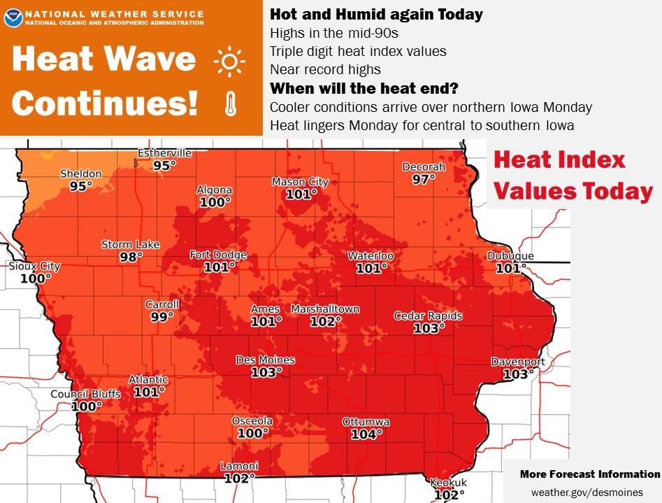
Today: **HEAT ADVISORY CONTINUES UNTIL 7-p.m.** Mostly sunny. High near 94. Heat index values as high as 101. South wind 10-20 mph, with gusts to near 30.
Tonight: Partly cloudy w/a 20% chance of showers and thunderstorms after 11pm. Low around 73. S @ 10-20 mph.
Monday: Partly sunny w/a 60% chance of showers and thunderstorms, mainly after 4pm. High near 90. SW @ 10. New rainfall amounts between a quarter and half of an inch possible.
Monday Night: A 70% chance of showers and thunderstorms, mainly through midnight. Mostly cloudy. Low around 68. New rainfall amounts between 1 and 2 inches possible.
Tuesday: Mo. Cldy w/a 30% chance of showers and thunderstorms. High near 82. New rainfall amounts of less than a tenth of an inch, except higher amounts possible in thunderstorms.
Tuesday Night: A 40% chance of showers and thunderstorms, mainly after midnight. Otherwise mostly cloudy, with a low around 65.
Wednesday: A 60% chance of showers and thunderstorms, mainly after 1pm, otherwise mostly cloudy, with a high near 78.
Saturday’s High in Atlantic was 91. Our Low this morning (thru 5:30-a.m.) was 75. Last year on this date, the High in Atlantic was 85 and the Low was 59. The Record High in Atlantic on June 17th was 102 in 1918. The Record Low was 40 in 1974.
357 AM CDT Sun Jun 17 2018
***A REMINDER: A HEAT ADVISORY REMAINS IN EFFECT UNTIL 7 PM (6/17)***
Persistent And Oppressive Heat Continues through today (Sunday). The combination of hot temperatures and humidity will produce dangerous heat conditions this weekend. Improvement is expected by Monday as a cold front drops into the state.
* TEMPERATURE…Highs generally in the low to mid 90s with dewpoints in the lower 70s, leading to heat index values of 100 to 105 degrees by this afternoon.
* IMPACTS…Lack of overnight relief from the heat will lead to additional stress. Gusty winds by this afternoon will increase the risk of dehydration. The prolonged nature of this event will compound and amplify heat-related impacts.
PRECAUTIONARY/PREPAREDNESS ACTIONS…
A Heat Advisory means that a period of hot temperatures is expected. The combination of hot temperatures and high humidity will combine to create a situation in which heat illnesses are possible. Drink plenty of fluids, stay in an air-conditioned
room, stay out of the sun, and check up on relatives and neighbors. Never leave infants, children or pets in a parked car, even for a minute.
Today: ***HEAT ADVISORY until 7-p.m. Sunday **Sunny & breezy, hot & humid. High near 95. Heat index values as high as 100. S @ 15-30 mph.
Tonight: Mostly clear & muggy. Low around 76. South wind 10 to 15 mph, with gusts as high as 20 mph.
Sunday: Mostly sunny, breezy, hot & humid. High near 94. South wind 15-30 mph.
Sunday Night: Mostly cloudy w/a 30% chance of showers and thunderstorms, mainly after 1am. Low around 74. S @ 10-25 mph.
Monday: Partly sunny w/a 40% chance of showers and thunderstorms, mainly after 1pm. High near 88.
Monday Night: A 40% chance of showers and thunderstorms. Mostly cloudy, with a low around 66.
Tuesday: A P/Cldy w/a 20% chance of showers and thunderstorms after 1pm. Partly sunny, with a high near 81.
Wednesday: P/Cldy. High 79.
Yesterday’s High in Atlantic was 92. Our Low this morning (as of 5:15-a.m.) was 75. Last year on this date our High was 86 and the Low was 65. The record High in Atlantic on this date was 103 in 1946. The Record Low was 42, in 1976.
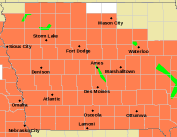
A Heat Advisory remains in effect for nearly the entire State of Iowa until 7-p.m. Sunday.
* TEMPERATURE...Highs generally in the mid 90s with dewpoints
  around 70, leading to heat index values of 100 to 105 degrees
  each afternoon.

* IMPACTS...Lack of overnight relief from the heat will lead to
  additional stress. Gusty daytime winds will increase the risk
  of dehydration. The prolonged nature of this event will
  compound and amplify heat-related impacts.

PRECAUTIONARY/PREPAREDNESS ACTIONS...

A Heat Advisory means that a period of hot temperatures is
expected. The combination of hot temperatures and high humidity
will combine to create a situation in which heat illnesses are
possible. Drink plenty of fluids, stay in an air-conditioned
room, stay out of the sun, and check up on relatives and
neighbors. Never leave infants, children or pets in a parked car,
even for a minute.
**Heat Advisory in effect this weekend, beginning 1-p.m. today**
Today: Partly cloudy, hot and humid. High 95. Winds S @ 15-30.
Tonight: Fair to P/Cldy. Low 74. S @ 10.
Tomorrow: P/Cldy. High 96. S @ 10-20.
Sunday: P/Cldy. High 95.
Monday: P/Cldy w/a chance of scattered showers & thunderstorms. High 90.
Yesterday’s High in Atlantic was 92. Our Low was 62 Last year on this date our High was 92 and the Low was 62. The record High in Atlantic on this date was 99 in 1918. The Record Low was 40, in 1906 & 1969.
336 AM CDT Fri Jun 15 2018
Very hot weather will begin by this afternoon and persist through Sunday. Daily high temperatures will range well into the 90s with heat index values in the 100 to 105 degree range each afternoon. In addition, overnight lows will only be in the 70s, especially south of Highway 30 where lows in the mid to upper 70s are forecast. This will lead to hazardous heat conditions through the weekend.
Heat Advisory in effect beginning this afternoon (Counties in orange)
Area Counties: Sac-Crawford-Carroll-Audubon-Guthrie-Dallas-Cass-Adair-Adams-Ringgold-Taylor-Union-Madison…A HEAT ADVISORY REMAINS IN EFFECT FROM 1 PM THIS AFTERNOON TO 7 PM CDT SUNDAY.
* TEMPERATURE…Highs generally in the mid 90s with dewpoints around 70, leading to heat index values of 100 to 105 degrees each afternoon.
* IMPACTS…Lack of overnight relief from the heat will lead to additional stress. Gusty daytime winds will increase the risk of dehydration. The prolonged nature of this event will compound and amplify heat-related impacts.
Area Counties: Monona-Harrison-Shelby-Pottawattamie…A HEAT ADVISORY REMAINS IN EFFECT FROM 1 PM THIS AFTERNOON TO 7 PM CDT SATURDAY…
* TEMPERATURE…Heat indices of 102 to 105 for a few hours each day Friday and Saturday afternoon. Actual air temperatures will be in the upper 90s.
PRECAUTIONARY/PREPAREDNESS ACTIONS…
A Heat Advisory means that a period of hot temperatures is expected. The combination of hot temperatures and high humidity will combine to create a situation in which heat illnesses are possible. Drink plenty of fluids, stay in an air-conditioned room, stay out of the sun, and check up on relatives and neighbors. Never leave infants, children or pets in a parked car, even for a minute.
Take extra precautions, if you work or spend time outside. When possible, reschedule strenuous activities to early morning or evening. Know the signs and symptoms of heat exhaustion and heat stroke. Wear light weight and loose fitting clothing when
possible and drink plenty of water. Anyone overcome by heat should be moved to a cool and shaded location. Heat stroke is an emergency, call 9 1 1.
…Prolonged Oppressive Heat Conditions Expected This Weekend…
Forecast confidence is extremely high for oppressive heat conditions beginning Friday afternoon and lasting through Sunday afternoon. Widespread daytime heat index values of over 100 degrees are expected. Overnight minimum temperatures will only
lower to the low to mid 70s. Daytime winds with gusts above 20 mph are expected.
Sac-Crawford-Carroll-Greene-Audubon-Guthrie-Dallas-Cass-Adair-Madison Counties (300 PM CDT Thu Jun 14 2018)
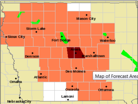
Heat Advisory for counties in orange
…HEAT ADVISORY IN EFFECT FROM 1 PM FRIDAY TO 7 PM CDT SUNDAY…
The National Weather Service in Des Moines has issued a Heat Advisory, which is in effect from 1 PM Friday to 7 PM CDT Sunday.
* TEMPERATURE…High temperatures will range from 95 to 99 degrees. With dewpoints in the low 70s, heat index values will range from 100 to 105 degrees throughout this time period.
* IMPACTS…Lack of overnight relief from the heat will lead to additional stress. Strong daytime winds will increase the risk of dehydration. The prolonged nature of this event will compound and amplify heat-related impacts.
PRECAUTIONARY/PREPAREDNESS ACTIONS…
A Heat Advisory means that a period of hot temperatures is expected. The combination of hot temperatures and high humidity will combine to create a situation in which heat illnesses are possible. Drink plenty of fluids, stay in an air-conditioned
room, stay out of the sun, and check up on relatives and neighbors. Do not wait until you are thirsty to drink. Avoid drinking alcoholic and caffeinated beverages as they dehydrate you.
Never leave infants, children or pets in a parked car, even for a minute.
Take extra precautions, if you work or spend time outside. When possible, reschedule strenuous activities to early morning or evening. Know the signs and symptoms of heat exhaustion and heat stroke. Wear light weight and loose fitting clothing when possible and drink plenty of water.
To reduce risk during outdoor work, the occupational safety and health administration recommends scheduling frequent rest breaks in shaded or air conditioned environments. Anyone overcome by heat should be moved to a cool and shaded location. Heat stroke is an emergency, call 9 1 1.
DES MOINES – High temperatures and clear skies on Friday and Saturday are likely to lead to elevated ozone levels. The Department of Natural Resources recommends that Iowans with respiratory or heart disease, the elderly, and children limit prolonged outdoor exertion during the afternoon and evening on Friday and Saturday.
Hot and sunny conditions are anticipated across the region, which favor the formation of photochemical smog. In these conditions, volatile organic compounds react with nitrogen oxide resulting in an increase in ozone. Volatile organic compounds are emitted from the evaporation of consumer and industrial solvents, such as the evaporation from gas tanks in vehicles or mowers. Nitrogen oxides are created by combustion, and are contained in the exhaust from vehicles and coal-fired boilers.
Iowans can keep track of evolving air quality conditions by checking the U.S. Environmental Protection Agency’s national air quality map at www.airnow.gov.


