Today: A 40% chance of showers and thunderstorms, mainly before 9am; Gradually becoming mostly sunny, with a high near 82. Southwest wind 10 to 15 mph becoming northwesterly this afternoon.
Tonight: Mostly clear, with a low around 62. Northwest wind 5 to 10 mph becoming calm in overnight.
Monday: Sunny, with a high near 85. Light south wind becoming south southeast 5 to 10 mph in the morning.
Monday Night: Partly cloudy, with a low around 68. Southeast wind around 10 mph.
Tuesday: Mostly sunny, with a high near 89.
Independence Day: Mostly sunny, with a high near 90.
Yesterday’s High in Atlantic was 89. Our Low was 69. We received 2.3-inches of rain at the KJAN Studios over the past 24-hours ending today at 7-a.m. Last year on this date our High was 82 and the Low was 59. The record High in Atlantic on this date was 104 in 1938. The Record Low was 45, in 1930, 1951 and 1995.
Strong thunderstorms packed heavy rain and wind Saturday evening and overnight. Here in Atlantic, we had received 1.88-inches of rain as of 9:50-p.m., Saturday. The gully washers came in two waves, the first of which began at around 6-p.m. The second produced some street flooding, the worst of which appeared to have been at Mulberry and East 3rd Street Place, where water was flowing down the street like a river for a time, and was easily two-feet deep.
Two-miles south of Creston, one-inch diameter hail was reported at around 7:30-p.m. Several tree branches, two- to four-inches in diameter were broken by the winds in Menlo, at around 8:30-p.m. In Winterset, a roof was blown off of a home and large trees fell around town at around 9-p.m. At about the same time, winds were gusting to near 60 mph in Panora.
In Central Iowa there were numerous reports of heavy rain and street flooding. KCCI reports a 65-year-old Des Moines man was swept away by floodwaters late Saturday near 50th Street and Twana Avenue. First responders found his body at around 12:40 a.m. today (Sunday).
As much as 10-inches of rain fell on the north side of Ankeny (as of 10:15-p.m.), 7.5-inches was reported in the Saylorville area, 7.2-inches was reported in the Urbandale area, 7.1-inches in Johnston, and 6.9-inches had fallen later Saturday night in the Alleman area.
Numerous reports of water rescues were underway across Ankeny, Johnston, Des Moines and Urbandale, where water was chest deep in some locations. The Iowa Department of Transportation reports some roads were partially closed due to flooding, including I-35 northbound between Ankeny and Alleman, where there were delays due to flooding across the Interstate. A portion of Highway 44 in Dallas County was also experiencing flooding, causing traffic delays.
And, the city of Ankeny was placed under a boil order after a water main broke Saturday night.
A deluge of rain has caused street flooding in Atlantic this evening. Be careful if you must drive, and if the water is flowing across a street or road, turn around! Don’t drown. Some locations include Mulberry Street between 5th St. and 3rd St. Place, near Henningsen Processing, and elsewhere downtown.
A FLASH FLOOD WATCH REMAINS IN EFFECT UNTIL 7-A.M. SUNDAY
Today: Increasing cloudiness. hot & humid, w/a 60% chance of showers & thunderstorms mainly after 4pm. Some of the storms could produce heavy rain. FLASH FLOOD WATCH (4-p.m. today thru 7-a.m. Sunday). High near 90. South wind 10-20 mph.
Tonight: Showers and thunderstorms w/heavy rain possible. Low around 70. S/SE @ 5-10. New rainfall amounts between 1 and 2 inches possible.
Sunday: A 20% chance of showers & thunderstorms through mid-day, otherwise Partly sunny & cooler. High near 83. Northwest wind 5 to 10 mph.
Sunday Night: Mostly clear, with a low around 66.
Monday: Sunny, with a high near 88. S/SE wind 5 to 10 mph.
Tuesday: Mostly sunny, hot & humid with a high near 90.
Wednesday (Independence Day): Mo. Sunny. High 91.
Yesterday’s High in Atlantic was 92. Our Low this morning was 75. Last year on this date our High was 80 and the Low was 57. The record High in Atlantic on this date was 101 in 1933. The Record Low was 43, in 1940.
DES MOINES, Iowa (AP) — High winds from a fast-moving storm front have knocked trees and limbs onto houses and cars and knocked out power to homes and businesses in several Iowa counties.
Gusts up to 80 mph were reported Thursday and winds nearing 60 mph were reported at Des Moines International Airport. At least two semitrailers were tipped over on Interstate 80 near Walnut and one on Interstate 35 near Bevington. No injuries were reported. At the Atlantic Municipal Airport, Thursday, the automated weather system recorded a wind gust of 61 mph just before 11-a.m. Numerous large trees were uprooted or had their limbs fall on property, including at least two vehicles, the Rolling Hills Bank sign on 7th Street was blown down, and power was out to several areas of town, with the west side having the longest outage while AMU crews worked to repair downed power lines. A fireworks vendor tent in the Atlantic Wal-Mart parking lot, was destroyed by the high winds.
In Anita, a tree fell on a house, but there were no injuries. Two-miles south of Massena, farm sheds were toppled and corn fields nearly flattened. Fontanelle and Greenfield reported damage in the form of fences down, a greenhouse was blown over the the Greenfield Shopko store, heavy rain and hail was reported. Winds gusted up to 70 mph. A home was damaged three-miles south of Greenfield, a machine shed was destroyed, a grain bin severely damaged and multiple trees were down in the same area. Downtown Greenfield also saw damage, with a gas leak – possibly storm related – having caused the evacuation and closing of the courthouse and neighboring businesses. The radio tower at the Adair County Hospital was blown down also. The Wallace Country Life Center near Orient also sustained damage. Officials report all hoop houses have MAJOR damage (most likely can not be repaired), the greenhouse had plastic ripped off but the structure seemed to have minimal damage, a tree was uprooted and numerous other branches were sheared-off. The west side of the house on the property was impaled by a tree branch that went through the wall and into the gift shop. There was roof damage on the barn, and the flag pole has a major bend in it. Winds topping 60 mph were reported in Stuart, Adair, Creston, Walnut and Harlan, to name a few of the communities affected by the storm. Scattered power outages were reported across the listening area.
Indianola officials say some trees posed a danger to cleanup efforts because they were touching downed power lines. Wind damage also was reported in Afton, Creston and Greenfield. A fireworks tent and fireworks were destroyed in Winterset.
Today: **HEAT ADVISORY 11-a.m. until 9-p.m.** Mostly sunny, hot & humid. High 97. Heat Index around 103. S @ 15-30.
Tonight: Partly cloudy. Low 76. S @ 10-15.
Tomorrow: P/Cldy w/a chance of afternoon showers & thunderstorms. High 93. S @ 10-20.
Sunday: Shwrs ending early; P/Cldy. High 84.
Monday: P/Cldy. High 86.
Yesterday’s High in Atlantic was 85. Our Low was 64. We received .82” rain yesterday. Last year on this date our High was 80 and the Low was 63. The record High in Atlantic on this date was 102 in 1934. The Record Low was 46, in 1950.
Information compiled by the National Weather Service
PRELIMINARY LOCAL STORM REPORT…SUMMARY
NATIONAL WEATHER SERVICE DES MOINES IA
422 PM CDT THU JUN 28 2018
..TIME… …EVENT… …CITY LOCATION… …
..DATE… ….MAG…. ..COUNTY LOCATION..ST.. …SOURCE….
..REMARKS..
1055 AM TSTM WND GST 2 WNW ATLANTIC
06/28/2018 M61 MPH CASS IA AWOS
1120 AM TSTM WND GST ADAIR
06/28/2018 M62 MPH ADAIR IA MESONET
RWIS STATION.
1125 AM TSTM WND DMG GREENFIELD
06/28/2018 ADAIR IA EMERGENCY MNGR
IN GREENFIELD AND FONTANELLE. 8 TO 10 INCH
DIAMETER TREES DOWN…BRANCHES, FENCES DOWN.
GREENHOUSE BLOWN OVER AT SHOPKO IN
GREENFIELD. DIME SIZE HAIL WITH HIGH WINDS
AND HEAVY RAIN IN STUART. TIME ESTIMATED.
1128 AM TSTM WND GST 5 N LENOX
06/28/2018 E65 MPH ADAMS IA PUBLIC
VIDEO VIA SOCIAL MEDIA.
1132 AM TSTM WND DMG GREENFIELD
06/28/2018 ADAIR IA FIRE DEPT/RESCUE
ESTIMATED 70 MPH WIND GUST. NUMEROUS TREE
BRANCHES DOWN BLOCKING SOME STREETS.
1135 AM TSTM WND DMG 3 S GREENFIELD
06/28/2018 ADAIR IA EMERGENCY MNGR
SIGNIFICANT WIND DAMAGE IN ADAIR COUNTY NEAR
GREENFIELD. MULTIPLE TREES DOWN, HOME DAMAGE
3 SOUTH OF GREENFIELD AND RADIO TOWER ON
HOSPITAL DOWN.
1139 AM TSTM WND GST 4 N CRESTON
06/28/2018 E60 MPH UNION IA PUBLIC
FROM PERSONAL WEATHER STATION AT
INTERSECTION OF CHERRY STREET AND REA ROAD.
1140 AM TSTM WND GST 8 S STUART
06/28/2018 E65 MPH ADAIR IA TRAINED SPOTTER
ESTIMATED 65 MPH WINDS ALONG WITH NICKLE
HAIL AND AT LEAST 3 INCH BRANCHES DOWN.
VISIBILITY NEAR ZERO IN HEAVY RAIN.
1140 AM TSTM WND GST CRESTON
06/28/2018 M69 MPH UNION IA AWOS
AT CRESTON AIRPORT.
1145 AM TSTM WND GST 1 NE CRESTON
06/28/2018 E60 MPH UNION IA AMATEUR RADIO
ELECTRICITY IS OUT.
1150 AM TSTM WND DMG 1 ESE CRESTON
06/28/2018 UNION IA AMATEUR RADIO
POWERLINES DOWN ALONG HIGHWAY 34 IN CRESTON.
1150 AM TSTM WND DMG AFTON
06/28/2018 UNION IA BROADCAST MEDIA
KCCI REPORTS MULTIPLE TREE BRANCHES DOWN
AROUND TOWN. TOWN IS WITHOUT POWER.
1154 AM TSTM WND DMG 3 SE GREENFIELD
06/28/2018 ADAIR IA TRAINED SPOTTER
MACHINE SHED DESTROYED, GRAIN BIN SEVERELY
DAMAGE AND MULTIPLE TREES DOWN.
1156 AM TSTM WND GST WINTERSET
06/28/2018 E60 MPH MADISON IA TRAINED SPOTTER
BRANCHES DOWN AT LOCATION IN WINTERSET. WIND
ESTIMATED.
12:38-p.m. – Adair County Courthouse in Greenfield is closed due to no power and wind damage.
12:15-p.m. – large tree limbs down, nickel size hail in Bevington (Madison County)
11:57-a.m. (Delayed report) Flag pole knocked down at a residence near the Atlantic High School. Burt Rhodes came and picked it up for the resident.
Rolling Hills Bank sign blown over in Atlantic.
11:56-a.m. – large tree limbs down in Winterset; 60 mph wind
11:50-a.m. – Storm spotters report large tree limbs down in Greenfield (11:30-a.m.). 70mph winds. Power out.
11:45-a.m. – Cass County EMA reports there were issues with communications as the storm blew through at speeds of 65-70mph; unconfirmed reports of vehicle overturned at Lake Anita.
11:45-a.m. – est. 60mph wind near Creston; power out.
11:45-a.m. – Fireworks tent damaged in the Walmart parking lot in Atlantic.
11:39-a.m. – .82″ rain recorded at KJAN studios in Atlantic.
11:28-a.m. – 65mph wind 5 miles N. of Lenox
11:25-a.m. – Tree fell on a residence in Anita (1000 block of Hillcrest Drive – NO injuries)
11:21-a.m. – Tree down and possibly on fire at 207 E. 6th in Massena; power lines down.
11:20-a.m. – 60 mph wind in Adair
11:18-a.m. Emergency Management/Law enforcement reports multiple locations in Atlantic have debris blocking the roads, power lines down. TRAVEL NOT ADVISED in Atlantic at this time.
10:55-a.m. – 2 miles W/NW of Atlantic: 61 mph winds (AWOS)
10:53-a.m. – Several large tree limbs down in Avoca (24″ dia,) and across Hwy 59.
10:50-a.m. – LARGE LIMBS AND WHOLE TREES DOWN IN WALNUT WITH SEVERAL CITY STREETS BLOCKED. AT LEAST ONE SEMI BLOWN OVER ALONG I-80 NORTH OF WALNUT. SOUNDED TORNADO SIRENS IN WALNUT FOR THE HIGH WINDS.
10:45-a.m. – 3 miles e. of Oakland: 14″ diameter tree limb down.
10:24-a.m. – 57 mph wind gust in Shelby
10:23-a.m. – .45″ heavy rain 1 mile N/NW of Woodbine (30 minutes accumulation)
10:09-a.m. – 59 mph winds reported 1 mile NW of Logan
10:06-a.m – Large tree limb down and power out in Mondamin.
9:40-a.m. – est. 70 mph winds 2 miles NE of Mondamin. Pea size hail and large tree limbs down.
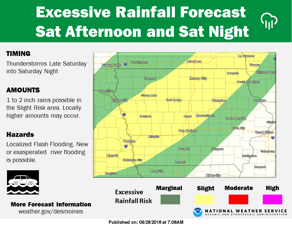
The National Weather Service reports s weak cold front will pass through Iowa late Saturday into Saturday Night bringing less heat to end the weekend, but it will also bring increased chances for thunderstorms. A few of these storms may be strong to severe but the extreme moisture content in the air will also produce conditions quite favorable for heavy rains. Rainfall amounts of 1 to 2 inches may occur from the Omaha area into northeast Iowa with locally heavier amounts possible. The risk area includes Atlantic, Audubon, Carroll, Corning, Council Bluffs, Denison, Greenfield, Guthrie Center, Harlan, Logan, and Winterset. Stay informed and be prepared for localized Flash Fooding.