While tornadoes can strike during any month of the year, Iowa is now out of the “peak” season for tornadoes and the numbers are well below the norm, according to meteorologist Craig Cogil at the National Weather Service. “So far this year across Iowa, we’ve seen 15 tornadoes,” Cogil says. “Typically by this point in the year, we’re much closer to 30 or 35 tornadoes, so, half of what we normally see.” Even with the 15 twisters, none of them were very powerful and there were no reports of any injuries or significant property damage. “Out of the 15 tornadoes, 13 of them were EF-0s and there have only been two EF-1s,” Cogil says, “and most of them have been in just corn fields or soybean fields, causing very little damage.”
While some storms this spring and summer have dropped significant rain that caused severe flooding in parts of the state, Iowa has managed to miss most of the -very- bad weather. “A lot of the systems that are really problematic for us just haven’t been occurring across the state,” Cogil says. “They’ve either gone south of us, some of them have been north of us. We just haven’t seen the set-up that really produces those big, dangerous days where we get a lot of the strong tornadoes.”
While Iowa’s only had 15 tornadoes this year, the state had 55 twisters in all of last year, including a dozen that were classified as EF-2s.
(Radio Iowa)
**HEAT ADVISORY in effect this afternoon and this evening**
Today: Partly cloudy. High 94. S @ 10-15 mph.
Tonight: P/Cldy. Low 74. S @ 5-10.
Tomorrow: P/Cldy. High 94. S @ 10-15.
Friday: Variably cloudy w/scattered showers & thunderstorms. High 90.
Saturday: V/Cldy w/scattered shwrs & tstrms. High 88.
Yesterday’s High in Atlantic was 93. Our Low this morning 68. Last year on this date our High was 93 and the Low was 70. The record High in Atlantic on this date was 104 in 1936. The Record Low was 43 in 1895.
Today: P/Cloudy, warm & humid. High 92. E @ 5-10.
Tonight: P/Cldy. Low 72. SE @ 5.
Tomorrow: P/Cldy. High 94. S @ 10-20 mph.
Thursday: P/Cldy w/a chance of thundershowers late. High 94.
Friday: Variably cloudy w/scattered shwrs & tstrms. High 90.
Yesterday’s High in Atlantic was 91. Our Low this morning 66. Last year on this date our High was 90 and the Low was 69. The record High in Atlantic on this date was 104 in 1930 and 1936. The Record Low was 46 in 1895 & 1996.
Today: Partly cloudy. High 93. SW @ 10-15.
Tonight: P/Cldy w/isolated showers possible. Low 74. SW-N @ 5.
Tomorrow: P/Cldy. High 91. NE @ 5-10.
Wednesday: P/Cldy. High 92.
Thursday: P/Cldy w/a chance of afternoon showers. High 93.
Yesterday’s High in Atlantic was 87. Our Low was 62. Last year on this date our High was 91 and the Low was 63. The record High in Atlantic on this date was 104 in 1930. The Record Low was 37 in 1895.
Today: Sunny, with a high near 86. South wind 5 to 10 mph.
Tonight: Clear, with a low around 63. South southeast wind around 7 mph.
Monday: Sunny, with a high near 89. Southwest wind 6 to 9 mph.
Monday Night: Mostly clear, with a low around 68. Southwest wind around 5 mph becoming light and variable.
Tuesday: Mostly sunny, with a high near 88. East wind around 7 mph.
Tuesday Night: Mostly clear, with a low around 68.
Wednesday: Sunny, with a high near 89.
Skyscan Forecast Saturday, July 6, 2018 Richard Garuckas
Today: Mostly sunny. High 83. SSE @ 5-10.
Tonight: Mostly clear. Low 61. SE @ 5-10.
Sunday: Mostly sunny. High 87. S @ 5-10.
Sunday Night: Mostly clear. Low 64.
Monday: Mostly sunny. Hot and humid. High 90.
Tuesday: Mostly sunny. High 91.
Wednesday: Mostly sunny. High 91.

Podcast: Play in new window | Download (680.3KB)
Subscribe: RSS
The head of the Iowa Flood Center says “for the time being” the flood threat has subsided in Iowa. “Some rivers, mostly in the north, are at elevated stage levels, some exceeding flood levels. And, of course, water flows downstream, so we expect tat some stations downstream will also experience hopefully minor flooding.” Hydrologist Witold Krajewski is the director of the Iowa Flood Center at the University of Iowa.
Krajewski says the peak flood season in Iowa is typically in May, June and early July — and the data shows flooding is becoming a “common” occurrence. “We are experiencing this. The temperatures and the humidity are slowly increasing and those are favorable conditions for precipitation,” Krajewski says. He recommends that city and county officials pour over the flood prediction maps his center has developed for Iowa and make plans for responding to flood levels that haven’t yet been seen in Iowa.
Krajewski made his comments during taping of the “Iowa Press” program for Iowa Public Television.
(Radio Iowa)
Today: Mo. Sunny, High 84. NE @ 10.
Tonight: Fair to Partly Cloudy. Low 60.
Tomorrow: P/Cldy. High 86. SE @ 10.
Sunday: P/Cldy. High 89.
Monday: P/Cldy w/isolated showers & thunderstorms. High 91.
Yesterday’s High in Atlantic was 83. Our Low this morning was 58. Last year on this date our High was 90 and the Low was 64. The record High in Atlantic on this date was 106 in 1937. The Record Low was 47 in 1967 & 2006.
Today: Mostly cloudy w/scattered showers & thunderstorms, mainly this morning. High 84. N @ 5-10.
Tonight: Partly cloudy. Low 64. N @ 5.
Tomorrow: P/Cldy. High 84. N@ 5-10.
Saturday & Sunday: P/Cldy. Highs in the mid-80’s.
Yesterday’s High in Atlantic was 91. Our Low this morning (as of 5:15-a.m.) was 69. Last year on this date our High was 89 and the Low was 64. The record High in Atlantic on this date was 107 in 1911. The Record Low was 41 in 1972.
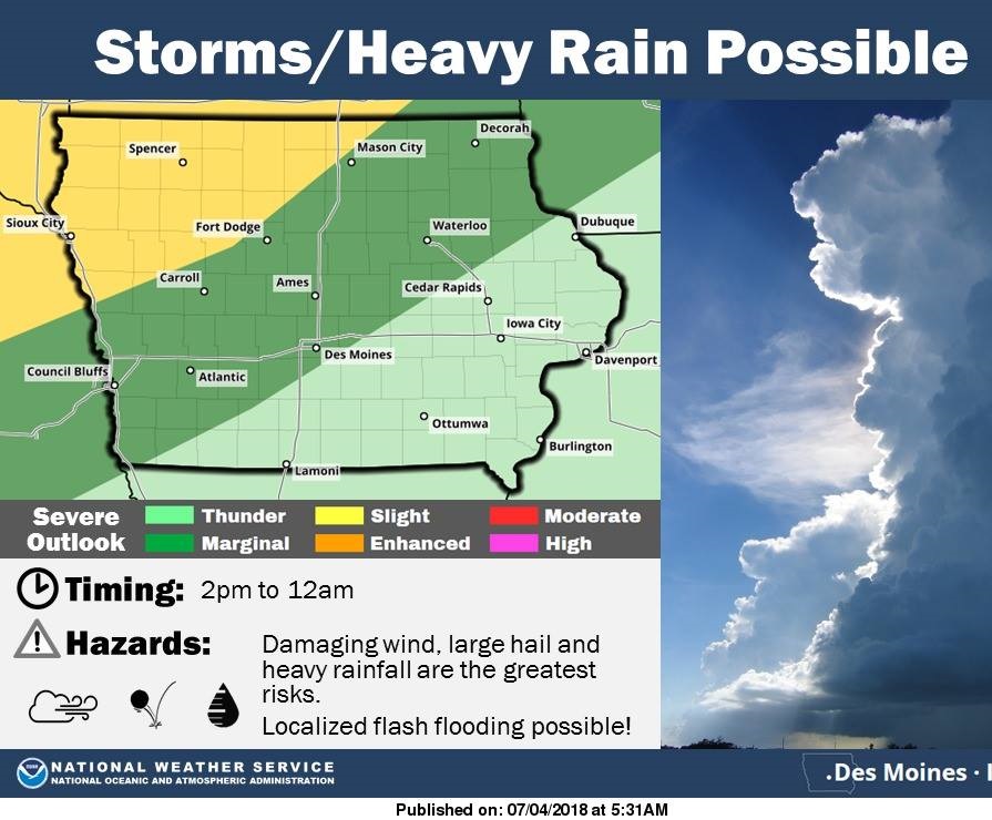
The National Weather Service says Mother Nature could provide her own version of fireworks today. Thunderstorms are expected to develop across much of northern Iowa, and become more widespread into the late afternoon and evening hours. Some severe storms will be possible, with damaging wind and large hail the main severe threats. Heavy rainfall is possible with the storms, which may lead to localized flash flooding.The timing for development of storms is anywhere from 2-p.m. until Midnight. Keep it tuned to KJAN, our website or mobile apps, for any weather watches or warnings that may be issued.