
Skyscan Forecast Saturday, November 24, 2018 Dan Hicks
**Winter Weather Advisory for Audubon, Guthrie, Cass, Adair, and Adams Counties from Midnight tonight to Sunday night**
**Winter Weather Advisory for Harrison, Shelby, Pottawattamie Counties from Midnight tonight until 6pm Sunday**
**Winter Weather Advisory for Mills and Montgomery Counties from 2:00am-6:00pm Sunday**
**Winter Weather Advisory for Fremont County from 4:00am-6:00pm Sunday**
**Winter Weather Advisory for Monona County from 9:00pm this evening until Noon Sunday**
**Winter Storm Warning for Union, Taylor, and Ringgold Counties from 3:00am-Midnight Sunday**
**Winter Storm Warning for Page County from 4:00am-6:00pm Sunday**
Today: Patchy fog early then partly cloudy this morning, increasing clouds this afternoon. NW-E @ 10. High 50.
Tonight: Cloudy. Rain developing changing to snow late. NE @ 10-20. Low 30.
Sunday: Cloudy. Snow in the morning, flurries in the afternoon. N @ 20-35. High 30. 2-4″ snow expected in the Atlantic area.
Monday: Partly cloudy. High 28.
Tuesday: Partly cloudy. High 28.

Podcast: Play in new window | Download (1.0MB)
Subscribe: RSS
OMAHA, Neb. (AP) — Forecasters say holiday travelers returning home should beware: A winter storm front is menacing most of Nebraska and southern Iowa. The National Weather Service issued winter storm watches Friday for both states. Expected winds gusting to 35 mph could create whiteout conditions with snowfall varying from 2 to even 8 inches in some spots.
The late fall system is expected to hit western Nebraska on Saturday afternoon, surging east and exiting Iowa by Sunday night.
Today: Rain, mainly after 9am. High near 48. South wind 8 to 15 mph, with gusts as high as 24 mph. Chance of precipitation is 80%. New precipitation amounts between a tenth and quarter of an inch possible.
Tonight: A 20 percent chance of rain before midnight. Mostly cloudy, with a low around 33. West wind around 8 mph.
Saturday: Increasing clouds, with a high near 49. West wind 5 to 7 mph becoming light and variable.
Sat. Night: Rain before 1am, then rain and snow between 1am and 2am, then snow after 2am. Patchy blowing snow after 4am. Low around 27. Windy, with a northeast wind 6 to 11 mph increasing to 17 to 22 mph after midnight. Winds could gust as high as 33 mph. Chance of precipitation is 90%. New snow accumulation of 1 to 2 inches possible. ***WINTER STORM WATCH in effect from 12-a.m. Sunday until 12-a.m. Monday**
Sunday: Snow likely, mainly before noon. Patchy blowing snow. Mostly cloudy, with a high near 29. Windy. Chance of precipitation is 70%.
Sunday Night: Mostly cloudy, with a low around 16. Blustery.
Monday: Mostly sunny, with a high near 26.
Yesterday’s High in Atlantic was 57. Our Low was 24. Last year on this date our High was 62 and the Low was 23. The record High in Atlantic on this date was 84 in 1953. The Record Low was -6 in 1898.
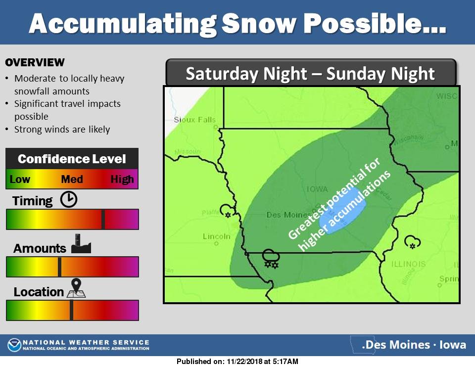
…Winter Storm to Impact Portions of Iowa This Weekend…
The National Weather Service says a winter storm is expected to impact portions of central and southern Iowa Saturday night into Sunday evening. This system will bring the potential for moderate to heavy snowfall and strong winds that may result in significant blowing snow. These conditions may lead to very difficult travel conditions.
330 AM CST Fri Nov 23 2018
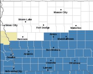
Winter Storm Watch from 12-a.m. Sunday through 12-a.m. Monday for Counties in blue.
A WINTER STORM WATCH IS IN EFFECT FROM LATE SATURDAY NIGHT THROUGH
SUNDAY EVENING for ALL COUNTIES IN THE KJAN LISTENING AREA (Cass, Adair, Adams, Audubon, Carroll, Crawford, Dallas, Guthrie, Fremont, Harrison, Mills, Montgomery, Page, Pottawattamie, Ringgold, Shelby, Taylor and Union. **For most counties, the Watch is in effect from 12-a.m. Sunday until 12-a.m. Monday, but for the far western counties it is in effect from 12-a.m. Sunday until 6-p.m.**
* WHAT…Moderate to heavy snow possible. Total snow accumulations of 3 to 8 inches possible with the heaviest amounts over southern Iowa. Winds gusts in excess of 40 mph possible.
* ADDITIONAL DETAILS…Travel could be very difficult. Blowing snow could significantly reduce visibility.
PRECAUTIONARY/PREPAREDNESS ACTIONS…
A Winter Storm Watch means there is potential for significant snow, sleet or ice accumulations that may impact travel. Continue to monitor the latest forecasts.
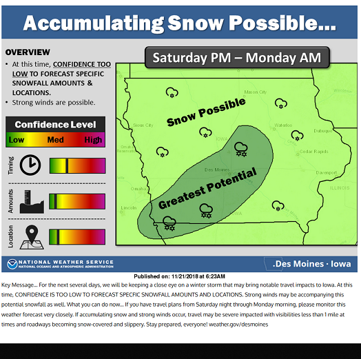
The National Weather Service in Des Moines reports a potential winter storm may impact the state Saturday night into Sunday night. Officials say “At this time, confidence is increasing that this system will impact central and southern Iowa with the potential for moderate snowfall and strong winds.” If you have travel plans from Saturday night through Sunday night, please monitor the weather forecast very closely. This system, according to the Weather Service, may cause significant travel impacts during this time period. Have alternate travel plans in place, and if you must travel, have a full tank of gas in your vehicle, and keep a winter weather survival kit in your vehicle.
 The kit should include: A cell phone charger; 1st aid kit; jumper cables; a spare tire; road flares; sand or kitty litter for traction; a tow rope; blankets; snow shovel and brush; a flashlight; hats, mittens and snow boots; water and snacks.
If you must drive during a storm, take the following precautions:
If your car gets stuck during a storm:
Today: Area of fog this morning; Partly cloudy & windy. High 57. S @ 15-30.
Tonight: P/cldy to cloudy. Low 40. S @ 5-10.
Tomorrow: Mostly cloudy w/light rain. High around 46. S @ 10-20.
Saturday: P/Cldy to Cldy. High 48.
Sunday:Cloudy & windy w/snow, especially in the morning. High around 31.
Yesterday’s High in Atlantic was 51. Our Low was 20. Last year on this date our High was 37 and the Low was 11. The record High in Atlantic on this date was 69 in 1966. The Record Low was -10 in 1937.
(Radio Iowa) — Tens of thousands of Iowans will be traveling for Thanksgiving and they could face a challenge getting home a few days after the holiday. The immediate forecast calls for warmer temperatures for much of Iowa with highs in the 40s and even low 50s in some areas. The National Weather Service say that should last into midday Saturday.
 A still-developing storm system may move in late Saturday, with the potential to drop temperatures into the 20s and drop several inches of snow into Sunday or Monday. Iowans are warned to pay close attention to the forecast, especially if they’ll be on the road later this weekend.
Today: Area of fog this morning; Partly cloudy. High 46. SE @ 10.
Tonight: P/cldy. Low 30. S @ 5-10.
Tomorrow (Thanksgiving Day): P/cldy & windy. High around 55. SW @ 15-30.
Friday: Cloudy w/light rain. High 45.
Saturday: Mostly cloudy. High around 47.
Yesterday’s High in Atlantic was 38. Our Low was 12. Last year on this date our High was 59 and the Low was 32. The record High in Atlantic on this date was 71 in 1990. The Record Low was -14 in 1937.
Today: Partly cloudy. High near 40. SW @ 10-15.
Tonight: P/cldy. Low 24. Winds light and variable.
Tomorrow: P/cldy. High around 46. SE @ 10.
Thursday: P/Cldy. High 55.
Friday: Mostly cloudy w/a chance of light rain. High near 50.
Yesterday’s High in Atlantic was 42. Our Low this morning was 11. Last year on this date our High was 50 and the Low was 18. The record High in Atlantic on this date was 75 in 1933. The Record Low was -1 in 1937 & 1985.
Today: Partly Cloudy. High around 35. S winds becoming NW @ 10-15 mph.
Tonight: Partly cloudy. Low 14.
Tomorrow: Mostly sunny. High 40. SW @ 10-15..
Wednesday: P/Cldy. High 48.
Thursday (Thanksgiving): P/Cldy. High 55.
Yesterday’s High in Atlantic was 30. Our Low was 6. Last year on this date our High was 46 and the Low was 18. The record High in Atlantic on this date was 73 in 1930. The Record Low was -1 in 1914.


