
OMAHA, Neb. (AP) — A winter storm dropping freezing rain and snow is tracking east across Nebraska into Iowa, prompting schools and businesses to remain closed for the day. The National Weather Service has issued winter weather advisories and warnings Tuesday that carry forecasts of up to 8 inches of snow for northeast Iowa. Up to 4 inches (10 centimeters) is expected to accumulate by the time the storm leaves Omaha, and as much as 5 inches is forecast to amass in the Des Moines area overnight into Wednesday.
Wind-driven snow and icy roadways are making travel hazardous. The Nebraska Transportation Department reports that Interstate 80 is partially covered with ice in central Nebraska, as are several other highways. No storm closures have been reported. Below-zero wind chill temperatures are forecast overnight.
Today: **WINTER WEATHER ADVISORY until 6-a.m. Wednesday, for mixed precip** Cloudy w/light snow/freezing drizzle this morning; Light snow this afternoon. High 31. SE-N winds @ 10-20.
Tonight: Cloudy w/snow diminshing late (2-4” total). Low 10. N @ 10-20..
Wedneday: P/Cldy. High 25. W @ 10-15.
Thursday: P/Cldy to Cldy. High 16.
Friday: Mo. Cldy w/light snow. High 14.
Our 24-hour High in Atlantic (as of 5-a.m. Today) was 28. Our Low was 9. Last year on this date our High was 39 and the Low was 26. The record High in Atlantic on this date was 60 in 1967. The Record Low was -27 in 1930.
Today: Mostly Cloudy w/scattered flurries. High 22. SE winds @ 10-20.
Tonight: Cloudy w/light freezing rain mixed with light snow. S/SE @ 10-15, w/steady to slowly rising temps overnight.
Tomorrow: Cldy w/light mixed precip becoming light snow in the afternoon. High 32. SE-N @ 10-20.
Wedneday: P/Cldy. High 25.
Thursday: P/Cldy to Cldy. High 18.
Yesterday’s High in Atlantic was 13. Our Low was 6. Last year on this date our High was 40 and the Low was 36. The record High in Atlantic on this date was 58 in 1933. The Record Low was -32 in 1976.
A fast moving storm is expected to cross southern Iowa Tuesday. The National Weather Service says it will bring a variety of winter weather to the region including periods of freezing drizzle and light snow late Monday night. Tuesday the north half has the greatest potential of seeing light to moderate snowfall while the south will see more of a mixture of light freezing rain, snow and even some light rain. Travel will be impacted by the falling snow and mixtures of precipitation with this event. Please monitor later forecasts for updates. 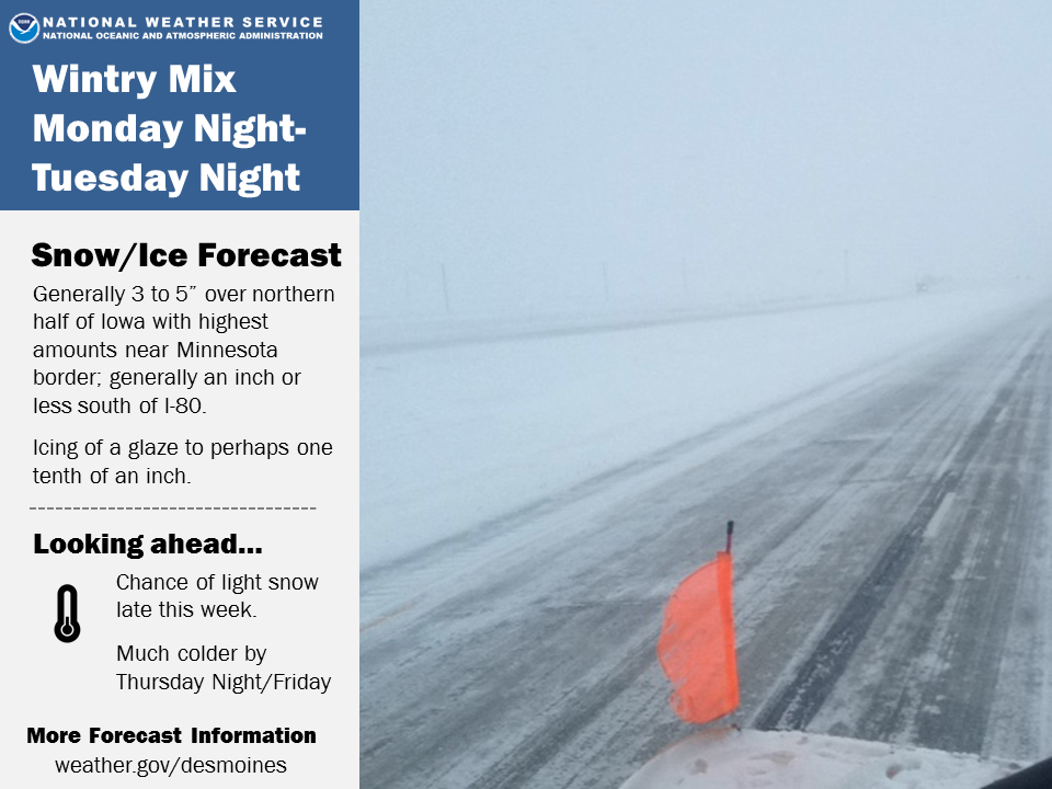
Today: Cloudy, with a high near 13. Wind chill values as low as -5. East wind 7 to 9 mph.
Tonight: Mostly cloudy, with a low around 7. Wind chill values as low as -10. East southeast wind 8 to 13 mph, with gusts as high as 21 mph.
M.L.King Day (Monday): Mostly cloudy, with a high near 26. Wind chill values as low as -5. Breezy, with a southeast wind 13 to 18 mph, with gusts as high as 28 mph.
Monday Night: A chance of freezing drizzle before 5am, then a chance of snow and freezing drizzle. Cloudy, with a temperature falling to near 24 by 8pm, then rising to around 30 during the remainder of the night. Breezy, with a southeast wind 13 to 16 mph, with gusts as high as 24 mph. Chance of precipitation is 50%. Little or no snow accumulation expected.
Tuesday: Snow and freezing rain. High near 32. Breezy, with a southeast wind 11 to 18 mph becoming north northwest in the afternoon. Winds could gust as high as 29 mph. Chance of precipitation is 90%. New ice accumulation of less than a 0.1 of an inch possible. New snow accumulation of 1 to 2 inches possible.
Tuesday Night: A chance of snow and freezing drizzle before 8pm, then a chance of snow between 8pm and midnight. Mostly cloudy, with a low around 10. Blustery. Chance of precipitation is 50%. New precipitation amounts of less than a tenth of an inch possible.
Wednesday: Mostly sunny, with a high near 23.
Skyscan Forecast Saturday, January 19, 2019 Dan Hicks
Today: Mostly cloudy in the morning with flurries. Becoming partly cloudy. N @ 15-30. High 15.
Tonight: Fairy to partly cloudy. Light and variable winds. Low -2.
Sunday: Mostly cloudy. A few flurries. SE @ 10-15. High 20.
Monday: Mostly cloudy. A few flurries. High 28.
Tuesday: Cloudy. Heavier mixed precipitation. High 34.
**We picked up 0.1 of an inch of ice accumulation and just a trace of snow at the KJAN studios from Friday afternoon to 6:00am Saturday.**

Podcast: Play in new window | Download (793.6KB)
Subscribe: RSS
**Winter Storm Warning effective Noon today until 6-a.m. Saturday**
Today: Cloudy with snow developing, mainly this afternoon. High 25. E/NE winds @ 10-20.
Tonight: Cloudy w/snow & blowing snow. Low 10. N @ 15-30mph. (2-5″ of snow is expected)
Tomorrow: Becoming Partly Sunny, High 11. N @ 15-25. Wind chill around -10.
Sunday: Mostly cloudy w/a chance of flurries. High 20.
Monday: Mo. Cldy w/a chance of mixed precip. High 32.
Yesterday’s High in Atlantic was 30. Our Low was 21. Last year on this date our High was 34 and the Low was 17. The record High in Atlantic on this date was 61 in 1951. The Record Low was -28 in 1984.
(Radio Iowa) — Winter was late in arriving to many areas of Iowa, but snow and colder temperatures are once again in the forecast for the state. National Weather Service meteorologist Jim Lee says a significant storm system will spread from northwest to southeast Iowa throughout the day tomorrow (Friday). “We’re looking at amounts generally in the 4 to 7 inch range. Some places will be a little bit higher and lower, but a pretty good accumulating snowfall,” Lee says.
High winds are expected with the snow – reducing visibility for motorists and possibly making roads slick. Much colder air will follow the snow with temperatures dropping into the single digits on Saturday and wind chill readings will fall well below zero Saturday night into Sunday. A Winter Weather Advisory remains in effect from Noon Friday until 6-a.m. Saturday, for most of the KJAN listening area.
(Updated):
Today: Any area of light snow ending; Cloudy. High 31. N @ 5-10.
Tonight: Cloudy. Low 20.
Tomorrow: **Winter Weather Advisory for snow & blowing snow, from Noon Friday until 6-a.m. Saturday. Mo. Cldy w/snow redeveloping. High 28. E @ 10. (1-2” poss.)
Tomorrow night: Snow mainly before midnight. Patchy blowing snow. Low 10. (new snow 2-4” possible). N/NE @ 20-30mph.
Saturday: Cldy & blustery, w/any snow ending. High 12.
Sunday: Mo. Cloudy. High 16.
Yesterday’s High in Atlantic was 25. We received .3” of snow overnight into this morning. Our Low was 15. Last year on this date our High was 25 and the Low was -2. The record High in Atlantic on this date was 57 in 1989. The Record Low was -21 in 1984.
Today: Mostly cloudy. High 30. N @ 5-10.
Tonight: Mo. Cldy w/ light snow developing late. Low 24. E @ 5-10.
Tomorrow: Mo. Cldy w/light snow in the morning (<1″). High 32. N @ 10.
Friday: Cldy w/snow, especially in the afternoon. High 28.
Saturday: Mo. Cloudy, windy and cold w/light snow in the morning. High 12.
Yesterday’s High in Atlantic was 33. We received freezing drizzle yesterday, amounting to a little more than a trace of precip. Our Low this morning was 19. Last year on this date our High was 7 and the Low was -9. The record High in Atlantic on this date was 64 in 1990. The Record Low was -25 in 2009.


