
Officials with the National Weather Service say extremely cold temperatures and wind chills are forecast by Tuesday and look to last through the end of next week. Highs by Wednesday are likely to remain below zero for much of the state and wind chill values look to plummet to 25 to 45 below zero Tuesday night and Wednesday night. This long duration temperatures and wind chills will be some of the coldest readings in recent years.
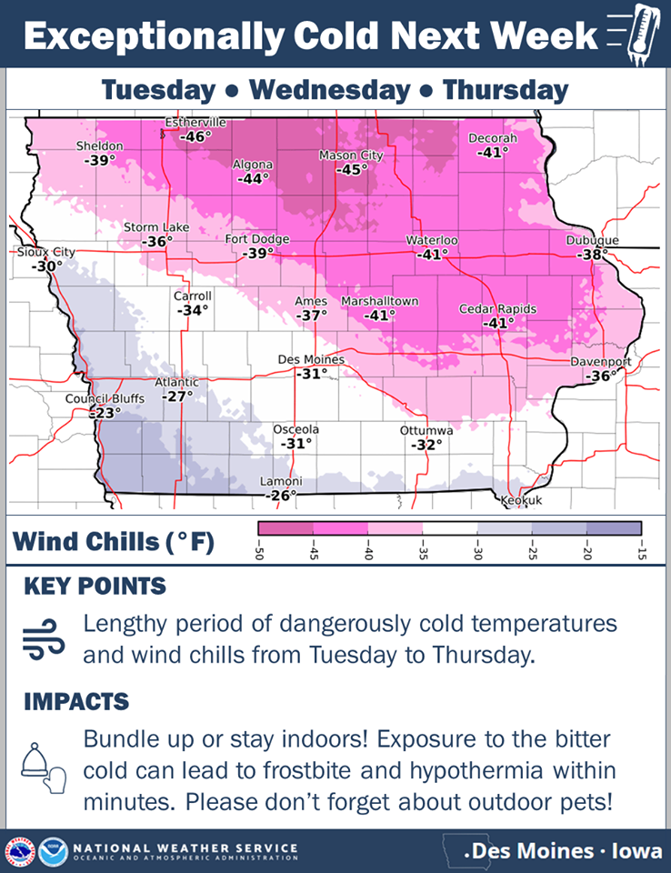
Click on the graphic to enlarge
DAVENPORT, Iowa (AP) — The deep freeze has prompted several eastern Iowa schools to cancel classes or start the school day late. The Davenport district and nearby Bettendorf and Muscatine schools canceled classes Friday. Davenport’s air temperature earlier this morning was minus 12, with a wind chill of minus 29. Wind at the time was reported at 8 mph. Late starts were scheduled for the Decorah, Louisa-Muscatine, Wapello and other districts, including many in southwest Iowa.
Alliant Energy says its crews are working on restoring power to more than 900 customers in frigid Clayton County who have been without power since about 5:15 a.m. The utility says it expects to have the electricity back on by 10 a.m. It’s unclear whether the cold caused the outage, however. Forecasters say the numbing cold is expected to linger into next week.
The National Weather Service says yet another winter storm is forecast Sunday night into Monday across much of Iowa. The greatest potential for moderate to heavy snow is located over north-central to northeast Iowa, while further southwest a wintry mix is anticipated. There remains some uncertainty in the snow amounts along the southwest edge of the snow band due to the wintry mix possibility Sunday night.
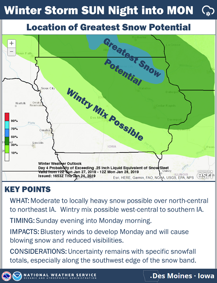
Click on the map to enlarge
Strong northwest winds develop Monday morning and will likely cause blowing and drifting snow throughout the day and even into Monday night. Then, bitter cold temperatures and wind chills are anticipated throughout the work week next week.
**Wind Chill Advisory in effect until 9-a.m. for wind chills of -15 to -25**
Today: Partly cloudy to cloudy w/scattered flurries. High 25. S/SE @ 10-20 mph.
Tonight: P/Cldy to Cldy. Low 8. N @ 5-10.
Tomorrow: Mostly cloudy w/light snow (<1″ expected). High 28. S @ 10.
Sunday: Mo. Cldy w/light snow. High 30.
Monday: Mo. Cldy w/light snow. High around 30 early, w/temps falling during the day.
Yesterday’s High in Atlantic was 23. Our Low this morning -12. Last year on this date our High was 43 and the Low was 17. The record High in Atlantic on this date was 65 in 1944. The Record Low was -28 in 1894.
MINNEAPOLIS (AP) — The Upper Midwest is about to plunge into a deep freeze. The National Weather Service says the wind chill factor could dip to 40 to 50 degrees below zero in parts of Wisconsin and Minnesota and to 30 to 35 below in the Dakotas starting Thursday night.
Such wind chills, which describe the combined effect of wind and cold temperatures on exposed skin, could cause frostbite within minutes. The wind chill advisory covers “pretty much the entire Upper Midwest,” stretching from the Dakotas into Kansas and east to Ohio, including northern Missouri, central Illinois and central Indiana, said meteorologist Bill Borghoff of the National Weather Service in Chanhassen, Minnesota. The deep freeze followed a cold front that pushed through Wednesday night into the Ohio Valley, he said.
Kenny Blumenfeld, senior climatologist with the Minnesota Department of Natural Resources’ State Climatology Office, said winter cold snaps on average are an annual occurrence in Minnesota. But extreme cold happens only about once every three to five years, he said. “It’s Minnesota. We’re supposed to go below zero and spend a lot of time not coming above zero. It’s part of our winter,” Blumenfeld said.
The deep freeze caused organizers of the Winter Carnival in Minnesota to cancel several events, including Thursday night’s parade through downtown St. Paul. Sioux Falls, South Dakota, has closed its six outdoor skating rinks because of the cold weather. Forecasters say the frigid weather is expected to stick around into next week.
Today: **Winter Weather Advisory in effect from 5-a.m. until 6-p.m.; Wind Chill Advisory in effect from 6-p.m. today until 9-a.m. Friday** Partly cloudy to cloudy w/scattered flurries. High in the 20’s early, w/temps falling to around 10 degrees by this afternoon. NW @ 15-30. Wind Chills around -15.
Tonight: P/Cldy. Low -5. V @ 5-10 w/gusts to around 20. Wind chills as low as -20.
Tomorrow: Mostly cloudy w/a chance of light snow or flurries. High 25. SE @ 10-20. Wind chills around -20.
Saturday: Mo. Cldy w/light snow or flurries. High 28.
Sunday: Mo. Cldy. High around 30.
Yesterday’s High in Atlantic was 25. Our Low was 11. Last year on this date our High was 35 and the Low was 19. The record High in Atlantic on this date was 66 in 1981. The Record Low was -24 in 1894.
OMAHA, Neb. (AP) — More wind-whipped snow is expected to hamper travel in eastern Iowa as Iowa and Nebraska residents dig out from a midwinter storm. The National Weather Service expects up to 3 inches of snow to fall in eastern Iowa today (Wednesday). Several school districts across both states canceled classes, including Des Moines Public Schools, while others planned late starts. Other districts decided to return to normal schedules after canceling Tuesday classes . Among them was the Omaha school district, although several suburban districts decided not to hold classes.
The weather service reports that as much as 8 inches fell over the past 24 hours in parts of southwest Nebraska and as much as 6 inches in portions of southwest Iowa. Iowa officials report that roads and highways remained covered with snow and ice in much of eastern and southwestern Iowa. Nebraska officials say most of eastern and central Nebraska’s highways are partially or completely covered.
Today: (Winter Weather Advisory for snow until 6-a.m.) Cloudy this morning w/any areas of snow ending; Becoming P/Cldy for this afternoon. High 24. N/NW @ 10-15.
Tonight: P/Cloudy. Low 8. SW winds becoming NW @ 10.
Thursday: P/Cldy to Cldy. High 16. NW @ 15-30.
Friday: Mo. Cldy w/light snow. High 16.
Saturday: Mo. Cldy w/flurries. High 20.
Yesterday’s High in Atlantic was 29. Our Low this morning was 13. We received 1.8 inches of snow here at the KJAN studios last night. Last year on this date our High was 27 and the Low was 13. The record High in Atlantic on this date was 60 in 1981. The Record Low was -24 in 1948.
OMAHA, Neb. (AP) — A winter storm dropping freezing rain and snow is tracking east across Nebraska into Iowa, prompting schools and businesses to remain closed for the day. The National Weather Service has issued winter weather advisories and warnings Tuesday that carry forecasts of up to 8 inches of snow for northeast Iowa. Up to 4 inches (10 centimeters) is expected to accumulate by the time the storm leaves Omaha, and as much as 5 inches is forecast to amass in the Des Moines area overnight into Wednesday.
Wind-driven snow and icy roadways are making travel hazardous. The Nebraska Transportation Department reports that Interstate 80 is partially covered with ice in central Nebraska, as are several other highways. No storm closures have been reported. Below-zero wind chill temperatures are forecast overnight.
Today: **WINTER WEATHER ADVISORY until 6-a.m. Wednesday, for mixed precip** Cloudy w/light snow/freezing drizzle this morning; Light snow this afternoon. High 31. SE-N winds @ 10-20.
Tonight: Cloudy w/snow diminshing late (2-4” total). Low 10. N @ 10-20..
Wedneday: P/Cldy. High 25. W @ 10-15.
Thursday: P/Cldy to Cldy. High 16.
Friday: Mo. Cldy w/light snow. High 14.
Our 24-hour High in Atlantic (as of 5-a.m. Today) was 28. Our Low was 9. Last year on this date our High was 39 and the Low was 26. The record High in Atlantic on this date was 60 in 1967. The Record Low was -27 in 1930.


