
Today: **Winter Storm Warning until 9-a.m.** Light snow or freezing drizzle this morning (less than 1″ new snow + glaze of ice); Cloudy. High 30. SE-NW @ 10-20.
Tonight: P/Cldy to Cldy. Low 15. NW @ 5.
Tomorrow: P/Cldy. High 31. Variable breeze @ 5-10.
Friday: Mo. Cldy. High 34.
Saturday: Cldy with a mix of rain and snow. High 37.
Yesterday’s High in Atlantic was 28. Our Low was -12. We received 4.5” of snow overnight and some freezing drizzle here at the KJAN studios. The melted snow amounted to .28” liquid precipitation. Last year on this date our High was 22 and the Low was 7. The record High in Atlantic on this date was 65 in 1925. The Record Low was -19 in 1978.
The winter storm for tonight hasn’t even started and yet the National Weather Service wants to bring your attention to the NEXT potent winter weather maker this coming weekend! Officials say a very potent system is slated to move through the region Saturday into Sunday with the potential for heavy snowfall (in northwest Iowa), a wintry mix (in central Iowa), and rain/wintry mix (in southeast Iowa) along, with strong winds (blowing snow). Keep your shovels and snow blowers handy and/or fueled-up for this weekend’s attack from Mother Nature. 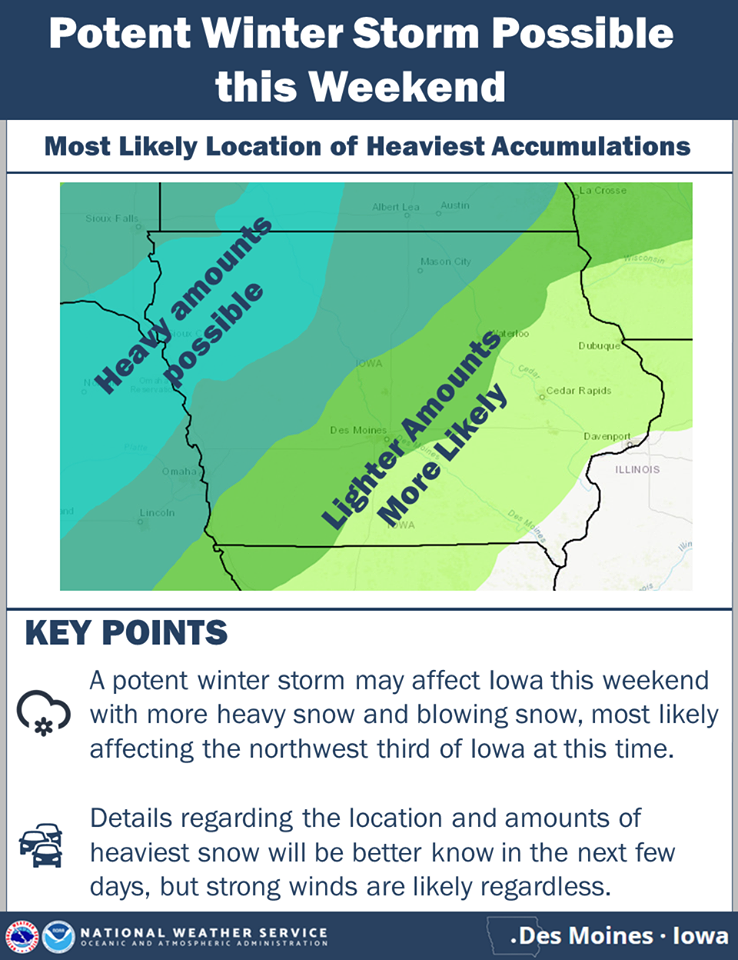
Today: Areas of morning fog; Partly cloudy to cloudy. High 24. SE @ 10 mph.
Tonight: **Winter Storm Warning from 6-p.m. Today thru 9-a.m. Wed.** Moderate to heavy snow. Temps nearly steady in the 20’s. E @ 10-15.
Tomorrow: Snow in the morning (5-8” total); Flurries during the afternoon. High 24. E-N @ 10-15.
Thursday: P/Cldy. High 29.
Friday: Mo. Cldy. High around 30.
Yesterday’s High in Atlantic was 25. Our Low this morning -12. Last year on this date our High was 31 and the Low was 22. The record High in Atlantic on this date was 71 in 2017. The Record Low was -22 in 1936.
Today: Any flurries ending this morning; Becoming Partly cloudy. High 20. N @ 10-15. WC near 0.
Tonight: P/Cldy. Low around 0. North wind around 5 mph. WC -5.
Tuesday: P/Cldy to Cldy w/a slight chance of snow after noon. High 26. SE @ 10 mph.
Tuesday Night: **Winter Storm Watch 6-p.m. Tue. Thru 9-a.m. Wed.**Snow, heavy at times. Temps nearly steady. E @ 10-20. Wednesday: Snow, mainly before noon (5-to 7-inches total expected). Mostly cloudy. High 28.
Thursday: P/Cldy. High 28.
Yesterday’s High in Atlantic was 31. We received 1.7” of new snow Sunday (for a total of 11.2”). Our Low this morning 7. Last year on this date our High was 56 and the Low was 31. The record High in Atlantic on this date was 67 in 2017. The Record Low was -25 in 1978.
***Winter Storm Warning for snow and difficult travel conditions: Cass-Adair-Adams-Dallas-Guthrie-Madison and Union Counties until 6-p.m.***
**Winter Weather Advisory for additional snow of up to 2 inches until Noon Today for Monona-Harrison- Shelby-Pottawattamie-Montgomery Counties.**
Today: Snow, mainly before 3pm. High near 26. Travel is NOT RECOMMENDED this morning. North northeast wind 5 to 10 mph. Chance of precipitation is 80%. New snow accumulation of around an inch possible.
Tonight: A chance of snow before 2am, then a chance of flurries between 2am and 3am. Cloudy, with a low around 13. Wind chill values as low as 5. Northwest wind around 10 mph. Chance of precipitation is 30%. New snow accumulation of less than a half inch possible.
Washington’s Birthday: Mostly cloudy, with a high near 21. Wind chill values as low as zero. North northwest wind 5 to 10 mph.
Monday Night: Mostly cloudy, with a low around 3. North northeast wind around 6 mph.
Tuesday: A 30 percent chance of snow after noon. Mostly cloudy, with a high near 18.
Tuesday Night: Snow. Low around 15. Chance of precipitation is 90%.
Wednesday: A slight chance of snow, mixing with freezing drizzle after 9am, then gradually ending. Mostly cloudy, with a high near 26. Chance of precipitation is 20%.
Skyscan Forecast Saturday, January 16, 2019 Dan Hicks
Today: Partly cloudy this morning with increasing clouds this afternoon. E @ 10. High 21.
Tonight: Cloudy with snow. ENE @ 10. Low 17.
Sunday: Cloudy with snow in the morning, flurries in the afternoon. N @ 10-20. High 26. 3-6″ of snow expected in the area from the system.
Monday: Partly cloudy. High 20.
Tuesday: Mostly cloudy. Light snow in the afternoon. High 25.

Podcast: Play in new window | Download (710.0KB)
Subscribe: RSS
Today: Partly cloudy to cloudy w/light snow late. High 16. E @ 10 mph.
Tonight: Cloudy early w/light snow ending (less than 1/2 total, expected). Becoming P/Cldy overnight. Low 0. N @ 5-10.
Saturday: Mo. Cldy w/a chance of light snow late, High 24. E @ 10.
Saturday night: A 90% chance of snow. Low 17.
Sunday: A 40% chance of snow. (2-4″ possible total). High 28.
Monday: P/Cldy. High around 20.
Thursday’s High in Atlantic was 34. Our Low through 5:15-a.m. today was 0. Last year on this date, the High in Atlantic was 44 and the Low was 10. The All-time Record High in Atlantic on Feb. 15th was 72 in 1921. The Record Low was -31 in 1905.
Today:Partly cloudy to cloudy. High this morning around 35, w/temps falling during the day. SE winds @ 10 mph becoming NW @ 15-20 this afternoon.
Tonight: P/Cloudy w/decreasing winds. Low 0.
Tomorrow: Mostly cloudy w/light snow in the afternoon. High 18. E @ 5-10.
Saturday:P/Cldy to Cldy w/light snow late. High 24.
Sunday: Mo. Cldy w/snow. High 26.
Yesterday’s High in Atlantic was 36. Our Low this morning 4. Last year on this date our High was 44 and the Low was 32. The record High in Atlantic on this date was 68 in 1934. The Record Low was -20 in 1936.
Today: Mostly sunny this morning; Partly cloudy this afternoon. High 32, SE @ 10-15.
Tonight: P/Cloudy. Low 28. S @ 5-10.
Tomorrow: P/Cldy to Cldy. High around 35 w/temps falling during the day. NW @ 15-30. Friday: P/Cldy to Cldy w/light snow in the afternoon. High 18. Saturday:P/Cldy to Cldy w/a chance of snow in the afternoon. High 24.
Yesterday’s High in Atlantic was 24. Our Low this morning 1. Last year on this date our High was 38 and the Low was 15. The record High in Atlantic on this date was 63 in 1934. The Record Low was -30 in 1905.


