
Today: Some areas of fog this morning; Partly cloudy. High 64. S @ 10-15.
Tonight: P/Cldy. Low 48. S @ 5-10.
Tomorrow: P/Cldy & windy. High 72. S @ 15-30 mph.
Saturday: A chance of rain in the morning; P/Cldy. High 62.
Sunday: P/Cldy. High 68.
Wednesday’s High in Atlantic was 56. Our Low this morning, 32. Last year on this date our High was 61 and the Low was 32. The record High in Atlantic on this date was 87 in 1947 & 2016. The Record Low was 12 in 1976.
Today: Partly cloudy. High around 54. NW winds at 10-20 mph.
Tonight: P/Cldy. Low 32. SE @ 5-10.
Tomorrow: P/Cldy. High 64. S @ 10-20.
Friday: P/Cldy. High 70.
Saturday: A chance of morning showers, otherwise P/Cldy. High 62.
Tuesday’s High in Atlantic was 58. Our Low this morning, 43. Last year on this date our High was 66 and the Low was 33. The record High in Atlantic on this date was 87 in 1921. The Record Low was 20 in 1976 and 1977.
Today: Partly cloudy. High around 58. NW @ 15-25 mph.
Tonight: Partly cloudy. Low 30. NW @ 5-10.
Tomorrow: Mostly sunny. High 58. NW @ 10.
Thursday: P/Cldy. High 62.
Friday: P/Cldy. High 68.
Monday’s High in Atlantic was 68. Our Low was 27. Last year on this date our High was 48 and the Low was 29. The record High in Atlantic on this date was 89 in 1892. The Record Low was 17 in 1952.
Today: Areas of morning fog; Mostly sunny. High around 62. S @ 10-15 mph.
Tonight: Partly cloudy. Low 45. S/NW @ 5-10.
Tomorrow: Isolated morning rain possible; P/Cldy. High 56. NW @ 15-25.
Wednesday: Mo. Sunny. High 56.
Thursday: P/Cldy. High 62.
Thursday’s High in Atlantic was 59. Our Low this morning 27. Last year on this date our High was 41 and the Low was 31. The record High in Atlantic on this date was 88 in 1897. The Record Low was 16 in 1937.
Today: Sunny, with a high near 52. West northwest wind 7 to 15 mph, with gusts as high as 24 mph.
Tonight: Clear, with a low around 30. West northwest wind around 5 mph becoming calm in the evening.
Columbus Day: Sunny, with a high near 63. Light southeast wind becoming south 8 to 13 mph in the morning. Winds could gust as high as 20 mph.
Tuesday: Sunny, with a high near 55. Windy, with a northwest wind 13 to 21 mph, with gusts as high as 29 mph.
Wednesday: Mostly sunny, with a high near 52.
Skyscan Forecast Saturday, October 12, 2019 Dan Hicks
Today: Partly cloudy. W @ 15-30. High 52.
Tonight: Fair to partly cloudy. W @ 5-10. Low 28.
Sunday: Partly cloudy. W @ 10-20. High 52.
Monday: Partly cloudy. High 62.
Tuesday: Partly cloudy to cloudy. A few showers. High 58.

Podcast: Play in new window | Download (590.9KB)
Subscribe: RSS
Today: Mostly cloudy & windy, w/a chance of sprinkles or flurries this morning. High around 42. W/NW @ 20-40 mph.
Tonight: Partly cloudy. Low 29. W/NW @ 10-15. FREEZE WARNING thru 9-a.m. Saturday.
Tomorrow: P/Cldy. High 50. W/NW @ 15-30.
Sunday: P/Cldy. High around 50.
Monday: P/Cldy. High near 60.
Thursday’s High in Atlantic was 65. Our Low this morning 35. Rainfall in Atlantic on Thursday amounted to .28”. Last year on this date our High was 49 and the Low was 35. The record High in Atlantic on this date was 93 in 1893. The Record Low was 17 in 1987.
FREEZE WARNING IN EFFECT FROM 10 PM THIS EVENING TO 9 AM CDT SATURDAY…
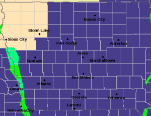
FREEZE WARNING tonight thru Saturday mid-morning (counties in purple)
* WHAT…Sub-freezing temperatures as low as 28 expected.
* WHERE…Most of Iowa.
* WHEN…From 10 PM this evening to 9 AM CDT Saturday.
* IMPACTS…Frost and freeze conditions will kill crops, other sensitive vegetation and possibly damage unprotected outdoor plumbing.
* ADDITIONAL DETAILS…Wind gusts of 15 to 25 mph will produce 15 to 25 degree wind chill temperatures.
PRECAUTIONARY/PREPAREDNESS ACTIONS…
Take steps now to protect tender plants from the cold. To prevent freezing and possible bursting of outdoor water pipes they should be wrapped, drained, or allowed to drip slowly. Those that have in-ground sprinkler systems should drain them and cover above-ground pipes to protect them from freezing.
**FREEZE WATCH IN EFFECT FROM FRIDAY EVENING THROUGH SATURDAY MORNING**
* WHAT…Sub-freezing temperatures as low as 29 possible.
* WHERE…Most of Iowa.
* WHEN…From Friday evening through Saturday morning.
* IMPACTS…Frost and freeze conditions could kill crops, other sensitive vegetation and possibly damage unprotected outdoor plumbing.
* ADDITIONAL DETAILS…For Saturday morning… expected wind speeds of 10 to 20 mph will drop wind chill values to the mid teens to low 20s across much of Iowa… especially northern
Iowa.
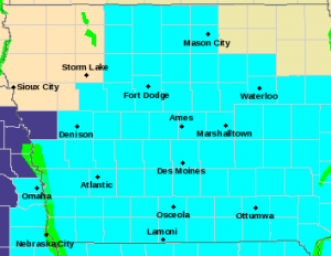
Freeze Watch in effect for counties in light blue; Freeze Warning for counties in purple.
A FREEZE WARNING IS IN EFFECT FOR MONONA COUNTY FROM 1-A.M. FRIDAY UNTIL 10-A.M. FRIDAY
PRECAUTIONARY/PREPAREDNESS ACTIONS…
Take steps now to protect tender plants from the cold. To prevent freezing and possible bursting of outdoor water pipes they should be wrapped, drained, or allowed to drip slowly. Those that have in-ground sprinkler systems should drain them and cover above-ground pipes to protect them from freezing.


