
Today: Partly cloudy & warmer. High 44. SW wind @ 10-15.
Tonight: Partly cloudy. Low 30. SW@ 5-10.
Tomorrow: P/Cldy. High 58. SW @ 10-20.
Sunday: Mostly Cloudy. An early High around 40, with falling temps during the day.
Monday: A chance of morning flurries. Becoming P/Cldy. High of 25
Yesterday’s High in Atlantic was 34. Our Low was 11. Last year on this date, the High in Atlantic was 34 and the Low was 23. The record High for this date in Atlantic, was 80 in 1999 & 2006. The Record Low was -12, in 1991.
(Radio Iowa) — While it was unseasonably cold across Iowa this (Thursday) morning, forecasters warn it’ll get much colder next week which will likely freeze soil moisture in place and raise the chances of spring flooding. Doug Kluck, the Central Region Climate Services Director for the National Weather Service in Kansas City, says his team of forecasters is watching several elements carefully. “You’ve got wet soils, you’ve got high reservoirs, it’s going to take a while to drain,” Kluck says, “Even the rivers will take a very long time to drain out and probably won’t until next spring, and that’s only if we don’t get average or above-normal precipitation during those times.”
The winter outlook calls for above-normal snowfall for most of the Northern Plains, though Kluck says there are no big indicators right now. “Something we lean on a lot in the climate world in terms of outlooks is El Nino and La Nina and we don’t have a strong one or the other pushing our forecast one way or the other,” Kluck says. “Those outlooks, although based on the best science that we have, have a relatively low confidence level attached to them.”
As for the winter ahead, Kluck says a quiet weather pattern would be the best-case scenario. “What we really need to happen is to have a relatively dry and a relatively warm winter season so we can get rid of some of the water that’s already existing across the entire Missouri and upper Midwest,” he says. Kluck notes snowpack is already accumulating in the Rocky Mountain region which will melt next spring and feed into the Missouri River basin, which has flooded repeatedly this year.
(Radio Iowa) — This is Winter Weather Awareness Day in Iowa and while the cold temperatures have made everyone well aware the season is coming — there are still some reminders of things to prepare. National Weather Service Meteorologist Kenny Podrazik says one thing you should do is to be sure the winter survival kit in your car is fully stocked for any trips. “You know if you’re doing some travel over the holidays. Pack your first aid kit, flashlight, shovel, some extra clothing, blankets, bottled water, some non-perishable food, things like that,” Podrazik says.
He says those items may’ve been removed from your car during the summer, and you should check to be sure you have everything you need. Podrazik says you should also make a plan for any winter weather that might knock out your power by being sure you have a backup heat source and working flashlights in your house. He says you should check everything now so you aren’t caught up with everyone else in line trying to do this as a storm approaches. “It’s better to get some things prepared now before that big winter storm comes. That way you are not caught up in the big traffic or things like that,” Podrazik says.
He says conditions can change quickly and it’s important to keep track of the forecast and changing conditions — especially if you are going to travel. “Definitely always check the forecast before you go out….you can check weathter-dot-gov for the latest forecast. We also recommend checking the latest conditions — that’s 5-1-1 for the Iowa D-O-T,” according to Podrazik. He says winter weather is going to hit sometime, but there’s no way to know when and how hard it will hit this year. He says there’s really no significant indicator one way or the other about the type of winter will have.
Podrazik says we’ve only had a taste of winter weather thus far and hopefully we won’t see a lot of storms until later on in the year.
Today: Mostly sunny. High 34. NW wind @ 10-15.
Tonight: Fair to partly cloudy. Low 12. SE@ 5.
Tomorrow: P/Cldy to cloudy. High near 40. SW @ 10-15.
Saturday: P/Cldy. High 57.
Sunday: P/Cldy to cldy w/an early high of 40 with falling temps during the day.
Yesterday’s High in Atlantic was 47. Our Low this morning (as of 5-a.m.) was 13. Last year on this date, the High in Atlantic was 38 and the Low was 24. The record High for this date in Atlantic, was 77 in 1915. The Record Low was -14, in 1991.
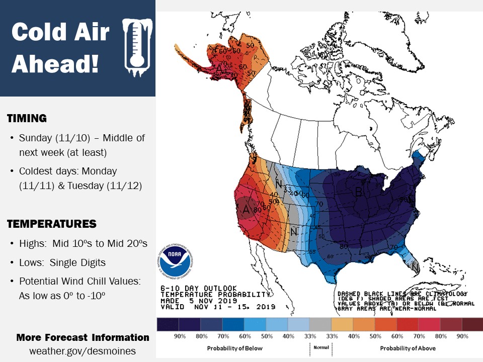
The National Weather Service in Des Moines reports “Confidence is very high in well-below temperatures across Iowa next week. Normal high temperatures for this time of year are generally in the low to mid 50s, and normal lows are in the mid 30s.” Meteorologists say as of now, there is potential for high temperatures on next Monday and Tuesday to struggle to make it into the 20s for much of Iowa, after low temperatures in the single digits. Those values would be around 20 to 30 degrees below normal for this time of year.
 With highs potentially reaching the 50s, this Saturday (11/9) will likely be the “warmest” day of the next week, so if you have outdoor activities, Saturday may be the day to get them done!
Today: Partly cloudy-to-cloudy. High 45. S winds becoming N @ 10-15.
Tonight: Mostly cloudy w/a chance of flurries; Becoming P/Cldy late. Low 14. N @ 15-30.
Tomorrow: P/Cldy. High 39. NW @ 10.
Friday: Mo. Cldy. High 42.
Saturday: P/Cldy. High 55.
Yesterday’s High in Atlantic was 42. Our Low was 25. Last year on this date, the High in Atlantic was 44 and the Low was 24. The record High for this date in Atlantic, was 77 in 1915. The Record Low was 9, in 1991.
Today: Partly cloudy to cloudy. High 45. SE @ 10 mph.
Tonight: Mostly cloudy. Low 35.
Tomorrow: Mostly cloudy. High 45. S-N @ 10-20.
Thursday: P/Cldy. High 36.
Friday: Mo. Cldy. High near 40.
Yesterday’s High in Atlantic was 49. Our Low this morning, was 25. Last year on this date, the High in Atlantic was 46 and the Low was 34. The record High for this date in Atlantic, was 78 in 1909. The Record Low was 3, in 1951.
Today: Partly cloudy to cloudy. High 48. NW @ 10-20 mph.
Tonight: Fair to P/Cldy. Low 25.
Tomorrow: Mostly cloudy. High 45. SE @ 10-15.
Wednesday: P/Cldy to Cldy. High 45.
Thursday: P/Cldy. High 38.
Yesterday’s High in Atlantic was 51. Our Low was 33. Last year on this date, the High in Atlantic was 42 and the Low was 35. The record High for this date in Atlantic, was 75 in 1909 & 1978. The Record Low was -1, in 1991.
Early this morning: Mostly clear, with a steady temperature around 34. Southwest wind around 8 mph.
Today: Increasing clouds, with a high near 53. Southwest wind 5 to 9 mph.
Tonight: Mostly cloudy, with a low around 35. Light and variable wind becoming west northwest 5 to 9 mph in the evening.
Monday: Partly sunny, with a high near 46. Northwest wind 9 to 15 mph, with gusts as high as 24 mph.
Monday Night: Partly cloudy, with a low around 24.
Tuesday: Partly sunny, with a high near 47.
Wednesday: Mostly sunny, with a high near 46.
Saturday’s High in Atlantic was 51. Our Low 27. Last Year on this date, the High in Atlantic was 44 and the Low 41. The Record High in Atlantic on Nov. 3rd, was 77 in 2008. The Record Low was 6, in 1966.
A fire started at a grocery store in Ogden sometime between 8-and 9-p.m., Saturday, grew to be so large and hot, that it became visible on a Weather Service satellite. According to reports, flames at the “Ogden Mart” on W. Walnut Street, shot 50-feet into the air. At least one wall of the building had collapsed overnight. Crews were still battling the blaze early this (Sunday) morning. There was no one in the building, and no injuries have been reported.

The Ogden Iowa grocery story fire during the evening of Saturday November 2 was hot enough to display on GOES-16 satellite imagery. This image was from 9:36pm CDT. The brighter, more yellowy colors depict the satellite sensing warmer temperature
The National Weather Service reports the fire was hot enough to display on GOES-16 satellite imagery. The Geostationary Operational Environmental Satellite 16 has 16 different channels to sample all sorts of different atmospheric phenomena.


