
Today: Cloudy through mid morning, then gradual clearing, with a high near 90. Light south wind becoming south southwest 9 to 14 mph in the morning. Winds could gust as high as 20 mph.
Tonight: A slight chance of showers and thunderstorms between 9pm and midnight. Mostly clear, with a low around 68. Southwest wind 8 to 13 mph becoming light and variable after midnight. Winds could gust as high as 21 mph. Chance of precipitation is 20%.
Monday: Mostly sunny, with a high near 92. North northwest wind 3 to 6 mph.
Monday Night: A 20 percent chance of showers and thunderstorms. Mostly clear, with a low around 69. Light and variable wind becoming south southeast around 6 mph after midnight.
Tuesday: Sunny and hot, with a high near 100. South wind 6 to 15 mph, with gusts as high as 22 mph.
Wednesday: A 40 percent chance of showers and thunderstorms, mainly before 1pm. Mostly sunny, with a high near 95.
Saturday’s High in Atlantic was 85. The Low was 53. Last year on this date the High in Atlantic was 81 and the Low was 57. The Record High on this date was 104 in 1955. The Record Low was 39 in 1971.
Today: Mostly Sunny. High 82. Wind South at 10 mph.
Tonight: Mostly clear, with a low around 64. South wind 5 to 10 mph.
Tomorrow: Mostly sunny, with a high near 88. S/SW @ 10-15.
Monday: Mostly sunny. High 93. W @ 10-15.
Tuesday: Sunny, hot & breezy. High near 102. Winds S @ 15-20.
Friday’s High in Atlantic was 83. Our Low was 51. Last year on this date, the High was 87 and the Low was 67. The Record High in Atlantic on this date was 102 in 1931 & 1947. The Record Low was 39, in 1971.
(Radio Iowa) – After a cool morning with some overnight lows in the 50s, forecasters say Iowa is in for a “prolonged heat event” next week. Meteorologist Alex Krull, at the National Weather Service, says the switch from July to August will bring us some excessively hot days, with highs in the low 90s expected Sunday and Monday. “Tuesday, we’re looking at actual air temperatures between the mid 90s and upper 90s and that’ll send heat index values — or the feels-like temperature — above 100 degrees,” Krull says.
“Then Wednesday, we’re looking at upper 90s for the actual air temperatures, and it may be possible for us to cross over 100 degrees and we’ll likely be looking at heat index values anywhere between 105 to 107 degrees.” Iowans will need to take precautions to cope with the steamy weather. “If you have any plans to be outdoors during the middle of this upcoming week, please plan accordingly,” Krull says. “Have plenty of water to stay hydrated and have a place to cool down, whether that be in a car that has working air conditioning or a building that is air-conditioned and shaded properly.”
Krull says the pattern of above-normal temperatures will continue perhaps for another ten days. “When we have this kind of pattern in July and August, it typically results in very hot and humid conditions throughout the next couple of weeks,” Krull says. “There may be some possibilities for rain showers and thunderstorms and anytime that those occur, they can provide some relief to the excessive temperatures.” The heat wave isn’t hitting just Iowa. Above-normal temps are forecast through the first week of August from Nebraska all the way to New York.
DES MOINES, Iowa — Iowa’s warm, dry weather has worsened the drought situation, while in states to the south, too much rain is the problem. That’s according to the latest Iowa Drought Monitor map which was released Thursday morning. The map shows over 56% of the state in abnormally dry conditions or some level of drought. That’s an increase of almost 10 percent. The hardest hit area is still northwestern Iowa. Extreme drought conditions, shown in red, have now extended into four counties there.
The Drought Monitor summary says “The Midwest saw a mix of degradations and improvements in the Drought Monitor this week, after weather was highly variable across the region. Hot and dry weather covered south-central and southwest Missouri, where flash drought continued to intensify and agricultural problems continued as a result.” Heavy rain fell in two areas, one from southeast of Kansas City to southeast Missouri, and a second in central, eastern, and northeast Missouri. The latter caused flash flooding in the St. Louis area and a record one-day rainfall at St. Louis Lambert Airport.” 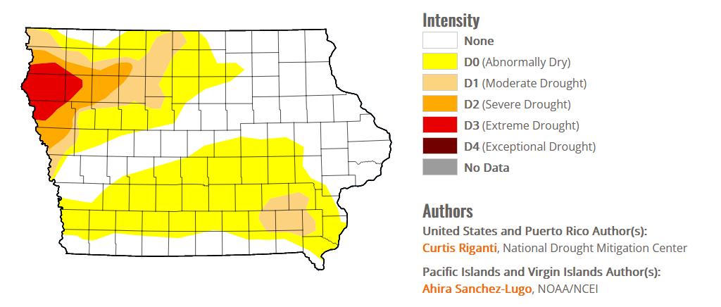 (click on the image to the right to enlarge)
Improvements to the drought situation occurred in parts of northeast Illinois, though heavier rains missed the severe drought area centered near Champaign. Drought expansion paused this week in the Michigan Lower Peninsula where widespread rain fell. Localized improvements were made in parts of Indiana, Ohio, and Kentucky where short-term conditions improved due to heavy rainfall. A mix of improvements and degradations occurred in Minnesota and Wisconsin around areas where heavier rain fell. Soil moisture deficits continued to mount in far northern Wisconsin, where moderate drought developed.
The latest 10-day forecast shows little chance for rain in Iowa.
Today: Mostly sunny. High 84. NW @ 10.
Tonight: Fair to P/Cldy. Low 57. Wind light & variable.
Tomorrow: Mostly sunny. High 87. S @ 5-10 mph.
Sunday: P/Cldy. High near 90.
Monday: Isolated morning showers/thunderstorms; P/Cldy. High 92.
Thursday’s High in Atlantic was 81. The Low this morning, 51. Last year on this date the High in Atlantic was 94 and the Low was 68. The Record High on this date was 102 in 1917. The Record Low was 46 in 1952.
Today: Partly cloudy. High 82. NW @ 10-15.
Tonight: Fair to P/Cldy. Low 55. Wind light & variable.
Tomorrow: P/Cldy. High 83. N @ 5-10 mph.
Saturday: P/Cldy. High 86.
Sunday: P/Cldy. High 89.
Wednesday’s High in Atlantic was 88. The Low this morning, 65. Last year on this date the High in Atlantic was 94 and the Low was 74. The Record High on this date was 105 in 1935. The Record Low was 43 in 2013.
Today: Partly cloudy. High 85. W/NW @ 10.
Tonight: P/Cldy to cloudy w/isolated showers late. Low 63. SW @ 5.
Tomorrow: Isolated showers ending in the morning; P/Cldy. High 82. N @ 10 mph.
Friday: P/Cldy. High 82.
Saturday: P/Cldy. High 85.
Tuesday’s High in Atlantic was 83. Rainfall overnight amounted to .04″. The Low was 63. Last year on this date the High in Atlantic was 92 and the Low was 64. The Record High on this date was 105 in 1930. The Record Low was 41 in 2013.
Today: Partly cloudy. High 82. SE @ 10-15.
Tonight: Mostly cloudy w/scatt. Shwrs & tstrms. Low 63. SE-NW @ 5-10.
Tomorrow: A chance of morning showers; P/Cldy. High 85. NW-SW @ 10 mph.
Thursday: Morning showers; P/Cldy. High 82.
Friday: P/Cldy. High 82.
Monday’s High in Atlantic was 77. We received a Trace of rain, Monday, at the KJAN studios. The Low this morning was 60. Last year on this date the High in Atlantic was 89 and the Low was 56. The Record High on this date was 109 in 1936. The Record Low was 43 in 1962.
Today: Partly cloudy to cloudy w/scattered showers and thunderstorms. High 78. EW @ 10.
Tonight: Mostly cloudy w/scatt. Shwrs & tstrms. Low 62. E @ 5-10.
Tomorrow: P/Cldy. High 82. E/SE @ 10 mph.
Wednesday: Morning showers & thunderstorms; Becoming P/Cldy. High 85.
Thursday: Morning showers & thunderstorms; Becoming P/Cldy. High again around 85.
Sunday’s High in Atlantic was 86. The Low was 59. Last year on this date the High in Atlantic was 88 and the Low was 56. The Record High on this date was during the height of the Dust Bowl. Atlantic reached 117 degrees on July 25, 1936, which has stood as the ALL-TIME Record High ever recorded here. The Record Low on this date was 44 in 1894.
(Radio Iowa) – Severe weather caused power outages and property damage in northeast Iowa this weekend. According to Winneshiek County Emergency Management, the city of Calmar was especially hit hard, including the Northeast Iowa Community College campus. Homes, buildings and cars were damaged. In Decorah, a popular trail that runs along the Upper Iowa River was closed due to flooding and storm damage.
The National Weather Service office in La Crosse reports a line of storms that swept through northeast Iowa Saturday night and Sunday morning produced strong winds and heavy rain in Winneshiek and Allamakee Counties. Some buildings were damaged in Waukon and there was significant tree damage reported around Waukon’s City Park.
Many residents of northeast Iowa spent Sunday cleaning up after a round of severe weather swept through the area Saturday night into Sunday morning. At the height of the storm, about 12-thousand customers had lost power. Sean Snyder, Emergency Management Coordinator in Winneshiek County, said “A lot of tree damage, a lot of downed power lines.”
“The City of Calmar was the hardest hit,” Snyder says. “NICC, South Winneshiek School District was hit as well as the residents of Calmar.” Snyder says there was structural damage to the Northeast Iowa Community College campus in Calmar. The Fidelity Bank will be closed today (Monday) due because of damage to the building on Calmar’s Main Street. Todd Shea with the National Weather Service office in La Crosse, Wisconsin, says their initial assessment is the damage in Calmar was caused by straight line winds.
“From what it appears from surveying and talking to officials in the area, we had just kind of a downburst or a swath of very intense thunderstorm winds that rolled through mainly the western and southern ends of the community,” Shea says. Calmar received three inches of rain as well. Nearly four inches fell in Decorah and storm damage closed a 13-mile bike trail around Decorah. In Allamakee County, a 60 mile an hour wind gust was recorded in Waukon and the Waukon City Park and Campground were damaged.


